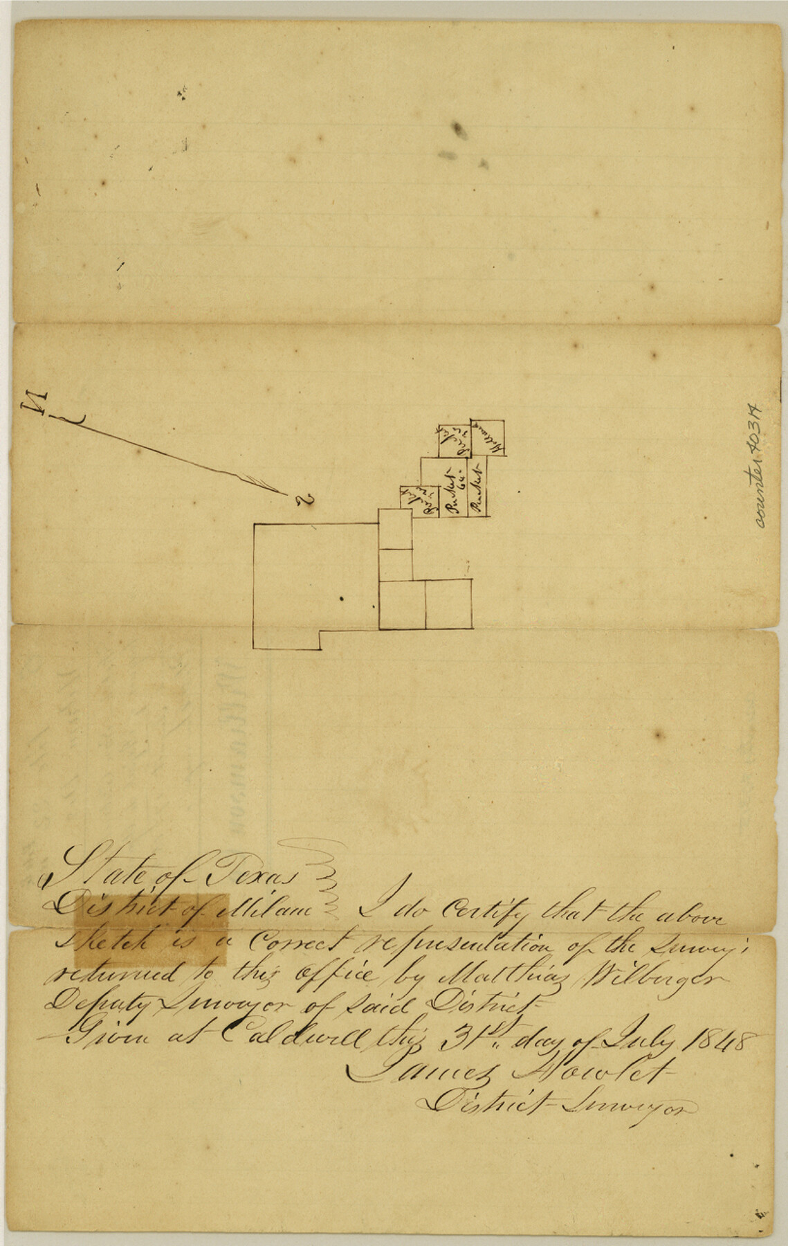
Williamson County Sketch File 6
[Sketch of surveys near the San Gabriel River in the Rafael de Aguirre 10 league grant]
-
Map/Doc
40314
-
Collection
General Map Collection
-
Object Dates
7/31/1848 (Creation Date)
8/17/1848 (File Date)
-
People and Organizations
James Howlet (Surveyor/Engineer)
-
Counties
Williamson
-
Subjects
Surveying Sketch File
-
Height x Width
12.8 x 8.1 inches
32.5 x 20.6 cm
-
Medium
paper, manuscript
-
Features
San Gabriel River
Part of: General Map Collection
Kent County Sketch File 12

Print $20.00
- Digital $50.00
Kent County Sketch File 12
1911
Size 26.8 x 23.6 inches
Map/Doc 11916
Hamilton County Working Sketch 21

Print $40.00
- Digital $50.00
Hamilton County Working Sketch 21
1955
Size 52.4 x 43.7 inches
Map/Doc 63359
Brewster County Working Sketch 104

Print $20.00
- Digital $50.00
Brewster County Working Sketch 104
1980
Size 30.6 x 46.0 inches
Map/Doc 67704
Flight Mission No. BQR-20K, Frame 4, Brazoria County

Print $20.00
- Digital $50.00
Flight Mission No. BQR-20K, Frame 4, Brazoria County
1952
Size 18.8 x 22.4 inches
Map/Doc 84106
Bowie County Working Sketch 19

Print $20.00
- Digital $50.00
Bowie County Working Sketch 19
1962
Size 23.3 x 17.9 inches
Map/Doc 67423
Current Miscellaneous File 53

Print $8.00
- Digital $50.00
Current Miscellaneous File 53
1945
Size 12.0 x 9.1 inches
Map/Doc 74038
Clay County Working Sketch 1

Print $20.00
- Digital $50.00
Clay County Working Sketch 1
Size 30.7 x 29.3 inches
Map/Doc 68024
Nacogdoches County Sketch File 2

Print $4.00
- Digital $50.00
Nacogdoches County Sketch File 2
1852
Size 8.0 x 6.4 inches
Map/Doc 32235
Eastland County Working Sketch 4

Print $20.00
- Digital $50.00
Eastland County Working Sketch 4
1918
Size 39.1 x 29.1 inches
Map/Doc 68785
Crosby County Rolled Sketch 2

Print $20.00
- Digital $50.00
Crosby County Rolled Sketch 2
1980
Size 24.7 x 18.7 inches
Map/Doc 5642
Maps & Lists Showing Prison Lands (Oil & Gas) Leased as of June 1955

Digital $50.00
Maps & Lists Showing Prison Lands (Oil & Gas) Leased as of June 1955
Size 11.2 x 8.9 inches
Map/Doc 62875
Sectional Map No. 3 of the lands and of the line of the Texas & Pacific Ry. Co. in Reeves and parts of Tom Green, Pecos, Presidio & El Paso Cos.

Print $20.00
- Digital $50.00
Sectional Map No. 3 of the lands and of the line of the Texas & Pacific Ry. Co. in Reeves and parts of Tom Green, Pecos, Presidio & El Paso Cos.
1885
Size 22.3 x 17.4 inches
Map/Doc 2303
You may also like
Pecos County Rolled Sketch 118

Print $20.00
- Digital $50.00
Pecos County Rolled Sketch 118
1941
Size 42.0 x 30.3 inches
Map/Doc 7260
[Sketch in DeWitt County]
![78383, [Sketch in DeWitt County], General Map Collection](https://historictexasmaps.com/wmedia_w700/maps/78383.tif.jpg)
Print $3.00
- Digital $50.00
[Sketch in DeWitt County]
Size 9.3 x 10.1 inches
Map/Doc 78383
Terry County Sketch File 2

Print $8.00
- Digital $50.00
Terry County Sketch File 2
Size 8.9 x 11.4 inches
Map/Doc 38012
Brazoria County Sketch File 45

Print $20.00
- Digital $50.00
Brazoria County Sketch File 45
1980
Size 32.0 x 43.1 inches
Map/Doc 10326
Jack County Working Sketch 23

Print $20.00
- Digital $50.00
Jack County Working Sketch 23
2006
Size 18.4 x 22.0 inches
Map/Doc 83606
Map of [Coleman County]
![3413, Map of [Coleman County], General Map Collection](https://historictexasmaps.com/wmedia_w700/maps/3413-1.tif.jpg)
Print $20.00
- Digital $50.00
Map of [Coleman County]
1878
Size 24.9 x 21.9 inches
Map/Doc 3413
Flight Mission No. CRC-3R, Frame 38, Chambers County

Print $20.00
- Digital $50.00
Flight Mission No. CRC-3R, Frame 38, Chambers County
1956
Size 18.7 x 22.4 inches
Map/Doc 84811

Map Showing the Jo Dick Slaughter Lands in Dawson, Martin, Borden, and Howard Counties, Texas

Print $20.00
- Digital $50.00
Map Showing the Jo Dick Slaughter Lands in Dawson, Martin, Borden, and Howard Counties, Texas
Size 26.6 x 20.8 inches
Map/Doc 92506
Flight Mission No. DAG-23K, Frame 178, Matagorda County

Print $20.00
- Digital $50.00
Flight Mission No. DAG-23K, Frame 178, Matagorda County
1953
Size 18.8 x 22.5 inches
Map/Doc 86513
Burnet County Sketch File 40

Print $4.00
- Digital $50.00
Burnet County Sketch File 40
Size 14.2 x 8.6 inches
Map/Doc 16755
Bailey County

Print $20.00
- Digital $50.00
Bailey County
1913
Size 28.8 x 22.3 inches
Map/Doc 66707