Atascosa County Sketch File A
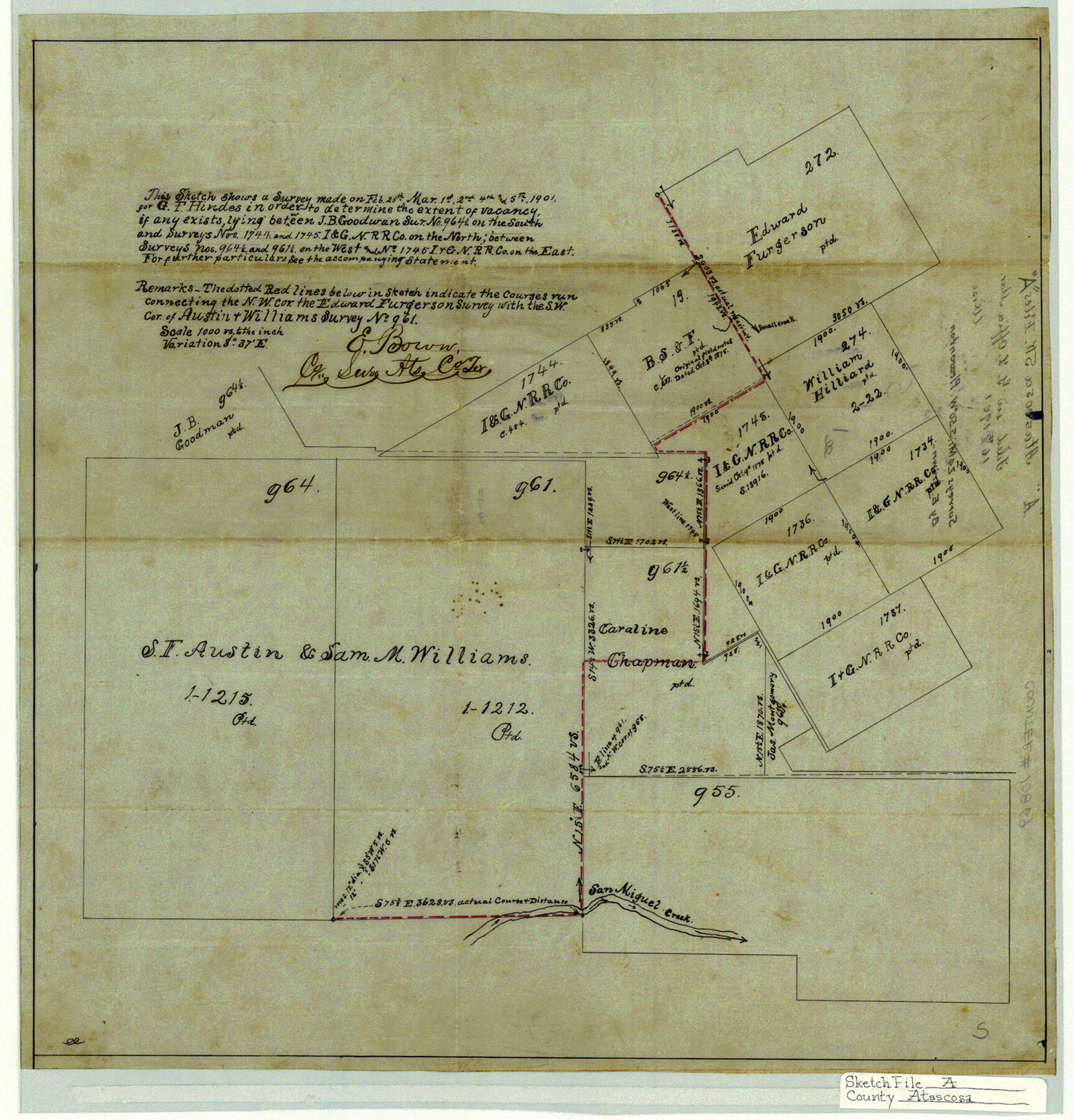
[Sketch to determine extent of vacancy if any exists in west part of county near Live Oak Creek]
-
Map/Doc
10869
-
Collection
General Map Collection
-
Object Dates
1901/3/16 (File Date)
-
People and Organizations
E. Brown (Surveyor/Engineer)
-
Counties
Atascosa
-
Subjects
Surveying Sketch File
-
Height x Width
16.3 x 15.6 inches
41.4 x 39.6 cm
-
Medium
linen, manuscript
-
Scale
1" = 1000 varas
-
Features
San Miguel Creek
Part of: General Map Collection
Fannin County Rolled Sketch 18A

Print $20.00
- Digital $50.00
Fannin County Rolled Sketch 18A
Size 15.1 x 33.6 inches
Map/Doc 5868
Gonzales County Working Sketch 5

Print $20.00
- Digital $50.00
Gonzales County Working Sketch 5
1980
Size 31.2 x 43.6 inches
Map/Doc 63221
Presidio County Rolled Sketch 139

Print $20.00
- Digital $50.00
Presidio County Rolled Sketch 139
2002
Size 24.5 x 27.5 inches
Map/Doc 78647

Edwards County Rolled Sketch 19

Print $20.00
- Digital $50.00
Edwards County Rolled Sketch 19
1947
Size 21.3 x 24.0 inches
Map/Doc 5808
Brazoria County Working Sketch 14

Print $20.00
- Digital $50.00
Brazoria County Working Sketch 14
1940
Size 33.6 x 43.9 inches
Map/Doc 67499
Nueces County NRC Article 33.136 Sketch 2

Print $20.00
- Digital $50.00
Nueces County NRC Article 33.136 Sketch 2
2002
Size 29.3 x 44.4 inches
Map/Doc 61622
Flight Mission No. DCL-7C, Frame 146, Kenedy County

Print $20.00
- Digital $50.00
Flight Mission No. DCL-7C, Frame 146, Kenedy County
1943
Size 18.8 x 22.4 inches
Map/Doc 86103
Fractional Township No. 7 South Range No 3 West of the Indian Meridian, Indian Territory

Print $20.00
- Digital $50.00
Fractional Township No. 7 South Range No 3 West of the Indian Meridian, Indian Territory
1898
Size 19.2 x 24.5 inches
Map/Doc 75193
Williamson County Sketch File 23

Print $4.00
- Digital $50.00
Williamson County Sketch File 23
1877
Size 12.8 x 8.1 inches
Map/Doc 40353
Flight Mission No. CLL-3N, Frame 33, Willacy County

Print $20.00
- Digital $50.00
Flight Mission No. CLL-3N, Frame 33, Willacy County
1954
Size 18.6 x 22.3 inches
Map/Doc 87090
Travis County Appraisal District Plat Map 2_2814

Print $20.00
- Digital $50.00
Travis County Appraisal District Plat Map 2_2814
Size 21.6 x 26.4 inches
Map/Doc 94218
You may also like
Hamilton County Working Sketch 17

Print $20.00
- Digital $50.00
Hamilton County Working Sketch 17
1951
Size 44.4 x 25.0 inches
Map/Doc 63355

Camp County, Texas

Print $3.00
- Digital $50.00
Camp County, Texas
1879
Size 9.6 x 16.8 inches
Map/Doc 512
Houston County Working Sketch 34

Print $40.00
- Digital $50.00
Houston County Working Sketch 34
Size 50.9 x 37.3 inches
Map/Doc 66264
Martin County Working Sketch 11

Print $40.00
- Digital $50.00
Martin County Working Sketch 11
1971
Size 49.8 x 38.1 inches
Map/Doc 70829
Map of West Part of Pecos Co.

Print $20.00
- Digital $50.00
Map of West Part of Pecos Co.
1896
Size 47.4 x 39.3 inches
Map/Doc 66974
Hudspeth County Working Sketch 43

Print $40.00
- Digital $50.00
Hudspeth County Working Sketch 43
1981
Size 37.4 x 53.7 inches
Map/Doc 66328
Mason County Rolled Sketch 1

Print $20.00
- Digital $50.00
Mason County Rolled Sketch 1
1939
Size 38.3 x 27.2 inches
Map/Doc 6673
Montague County Rolled Sketch 1

Print $20.00
- Digital $50.00
Montague County Rolled Sketch 1
Size 31.7 x 26.9 inches
Map/Doc 6786
Jack County Sketch File 31

Print $40.00
- Digital $50.00
Jack County Sketch File 31
1926
Size 8.8 x 7.2 inches
Map/Doc 27565
Kent County Working Sketch 12

Print $20.00
- Digital $50.00
Kent County Working Sketch 12
1953
Size 33.8 x 24.3 inches
Map/Doc 70019
Flight Mission No. DQO-7K, Frame 98, Galveston County

Print $20.00
- Digital $50.00
Flight Mission No. DQO-7K, Frame 98, Galveston County
1952
Size 18.8 x 22.4 inches
Map/Doc 85113