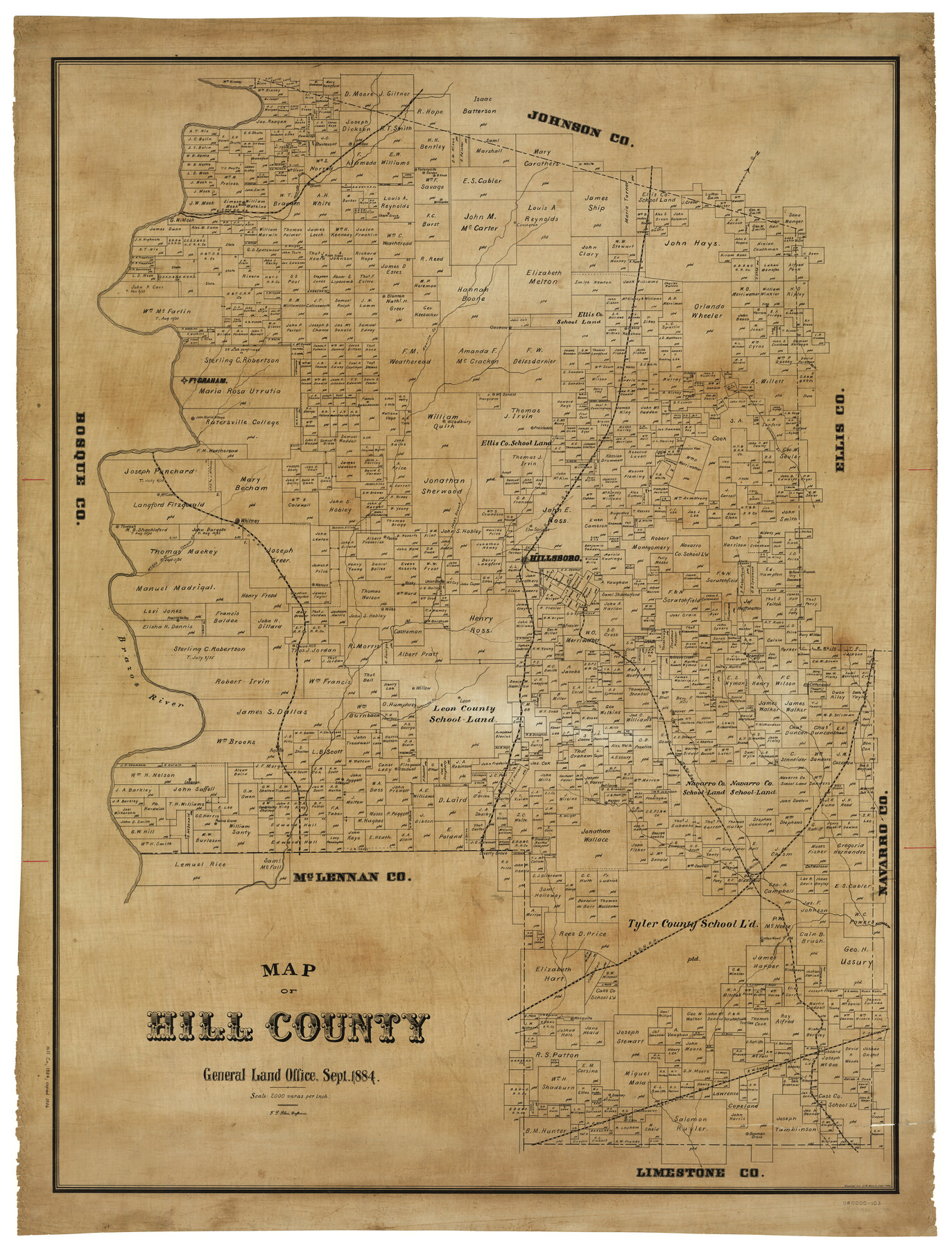
Map of Hill County
-
Map/Doc
4979
-
Collection
General Map Collection
-
Object Dates
9/1884 (Creation Date)
-
People and Organizations
Texas General Land Office (Publisher)
F.G. Blau (Draftsman)
F.G. Blau (Compiler)
-
Counties
Hill
-
Subjects
County
-
Height x Width
48.4 x 37.7 inches
122.9 x 95.8 cm
-
Comments
Copied in September 1906 by J. W. Morris.
Part of: General Map Collection
Nueces County Sketch File 25a

Print $6.00
- Digital $50.00
Nueces County Sketch File 25a
1890
Size 14.2 x 8.4 inches
Map/Doc 32578
Denton County Working Sketch 6

Print $20.00
- Digital $50.00
Denton County Working Sketch 6
1958
Size 21.3 x 33.0 inches
Map/Doc 68611

Pecos County Working Sketch 121

Print $20.00
- Digital $50.00
Pecos County Working Sketch 121
1973
Size 44.3 x 37.7 inches
Map/Doc 71594
Brewster County Rolled Sketch 114

Print $20.00
- Digital $50.00
Brewster County Rolled Sketch 114
1964
Size 11.5 x 18.5 inches
Map/Doc 5271
South Part Pecos County

Print $20.00
- Digital $50.00
South Part Pecos County
1976
Size 35.0 x 42.9 inches
Map/Doc 77393
La Salle County Boundary File 57b

Print $20.00
- Digital $50.00
La Salle County Boundary File 57b
Size 25.6 x 20.6 inches
Map/Doc 56258
Upton County Rolled Sketch 15

Print $20.00
- Digital $50.00
Upton County Rolled Sketch 15
1927
Size 25.0 x 19.2 inches
Map/Doc 8070
Tarrant County Sketch File 19

Print $4.00
- Digital $50.00
Tarrant County Sketch File 19
Size 9.7 x 8.1 inches
Map/Doc 37721
Tom Green County Rolled Sketch 8

Print $20.00
- Digital $50.00
Tom Green County Rolled Sketch 8
Size 18.3 x 26.0 inches
Map/Doc 7996
Brewster County Sketch File 19

Print $6.00
- Digital $50.00
Brewster County Sketch File 19
1943
Size 13.2 x 8.8 inches
Map/Doc 15817
Calhoun County Working Sketch 14

Print $20.00
- Digital $50.00
Calhoun County Working Sketch 14
1991
Size 28.7 x 33.9 inches
Map/Doc 67830
You may also like
Brewster County Sketch File N-22

Print $40.00
- Digital $50.00
Brewster County Sketch File N-22
Size 12.4 x 21.4 inches
Map/Doc 10969
Map of Erath County

Print $40.00
- Digital $50.00
Map of Erath County
1896
Size 49.6 x 43.5 inches
Map/Doc 4943
[K. N. Hapgood's Pasture and surrounding surveys]
![90432, [K. N. Hapgood's Pasture and surrounding surveys], Twichell Survey Records](https://historictexasmaps.com/wmedia_w700/maps/90432-1.tif.jpg)
Print $2.00
- Digital $50.00
[K. N. Hapgood's Pasture and surrounding surveys]
1923
Size 8.7 x 11.5 inches
Map/Doc 90432
Map of Dalhart

Print $20.00
- Digital $50.00
Map of Dalhart
1905
Size 23.5 x 32.0 inches
Map/Doc 92146
Nueces County Working Sketch 9

Print $20.00
- Digital $50.00
Nueces County Working Sketch 9
1977
Size 36.1 x 24.1 inches
Map/Doc 71311
Summer and Winter Health and Pleasure Resorts

Summer and Winter Health and Pleasure Resorts
1890
Size 7.7 x 5.6 inches
Map/Doc 97076
Flight Mission No. CRC-2R, Frame 198, Chambers County

Print $20.00
- Digital $50.00
Flight Mission No. CRC-2R, Frame 198, Chambers County
1956
Size 18.7 x 22.4 inches
Map/Doc 84776
Haskell County

Print $20.00
- Digital $50.00
Haskell County
1933
Size 41.7 x 36.2 inches
Map/Doc 77307

McLennan County Sketch File 23

Print $4.00
- Digital $50.00
McLennan County Sketch File 23
Size 5.6 x 3.2 inches
Map/Doc 31297
Mason County Sketch File 7

Print $4.00
- Digital $50.00
Mason County Sketch File 7
Size 7.9 x 8.8 inches
Map/Doc 30689
Andrews County Sketch File 16

Print $12.00
- Digital $50.00
Andrews County Sketch File 16
1934
Size 11.2 x 8.8 inches
Map/Doc 12897