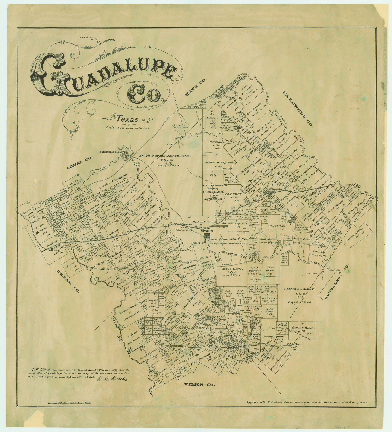
Guadalupe County, Texas
-
Map/Doc
491
-
Collection
Maddox Collection
-
Object Dates
1880 (Creation Date)
1880 (Copyright Date)
-
People and Organizations
General Land Office (Publisher)
W.C. Walsh (GLO Commissioner)
August Gast & Co. (Lithographer)
-
Counties
Guadalupe
-
Subjects
County
-
Height x Width
24.7 x 22.5 inches
62.7 x 57.2 cm
-
Medium
paper, etching/engraving/lithograph
-
Scale
1:4000
-
Comments
Conservation funded in 2005 with donations by The Capital Group Companies Charitable Foundation in honor of Rod Huber
-
Features
Santa Clara Creek
Eclato Creek
Castleman's Creek
Gonzalez Road
Elm Creek
Cibolo River
Mill Road
Seguin Road
Menchaca Creek
Nash Creek
Mill Creek
Seguin
Guadalupe River
Cottonwood Creek
G&SA
Comal Creek
Kingsbury
Highsmith's Creek
San Marcos River
York's Creek
Panete Creek
Mesquete Creek
Waterhole Creek
Comal River
New Braunfels
Part of: Maddox Collection
[Santa Rosa Leagues, Brooks & Kenedy Counties, Texas]
![10774, [Santa Rosa Leagues, Brooks & Kenedy Counties, Texas], Maddox Collection](https://historictexasmaps.com/wmedia_w700/maps/10774.tif.jpg)
Print $20.00
- Digital $50.00
[Santa Rosa Leagues, Brooks & Kenedy Counties, Texas]
Size 21.0 x 24.6 inches
Map/Doc 10774
Map of Bastrop County, Texas

Print $20.00
- Digital $50.00
Map of Bastrop County, Texas
1879
Size 25.2 x 23.3 inches
Map/Doc 693
[L.C. Ferguson Survey, Irion County]
![537, [L.C. Ferguson Survey, Irion County], Maddox Collection](https://historictexasmaps.com/wmedia_w700/maps/0537.tif.jpg)
Print $3.00
- Digital $50.00
[L.C. Ferguson Survey, Irion County]
Size 11.8 x 12.3 inches
Map/Doc 537
[S. C. Vineyard and Adjacent Surveys, Aransas County, Texas]
![82558, [S. C. Vineyard and Adjacent Surveys, Aransas County, Texas], Maddox Collection](https://historictexasmaps.com/wmedia_w700/maps/82558.tif.jpg)
Print $20.00
- Digital $50.00
[S. C. Vineyard and Adjacent Surveys, Aransas County, Texas]
Size 24.7 x 18.6 inches
Map/Doc 82558
Map of Survey 7, Block 1, D.B. Gardner

Print $20.00
- Digital $50.00
Map of Survey 7, Block 1, D.B. Gardner
1915
Size 16.9 x 22.3 inches
Map/Doc 5067
Survey in South Austin for Mr. R.N. Graham

Print $20.00
- Digital $50.00
Survey in South Austin for Mr. R.N. Graham
1915
Size 22.6 x 33.8 inches
Map/Doc 564
Map of Runnels County, Texas

Print $20.00
- Digital $50.00
Map of Runnels County, Texas
1879
Size 28.7 x 22.5 inches
Map/Doc 604

[Brooks & Burleson Block 4, Hartley County]
![5037, [Brooks & Burleson Block 4, Hartley County], Maddox Collection](https://historictexasmaps.com/wmedia_w700/maps/5037.tif.jpg)
Print $3.00
- Digital $50.00
[Brooks & Burleson Block 4, Hartley County]
Size 10.3 x 9.5 inches
Map/Doc 5037
Sketch of Motley Co.

Print $20.00
- Digital $50.00
Sketch of Motley Co.
1883
Size 19.7 x 20.2 inches
Map/Doc 75560
[El Javali Grant,] Sketch of 2560 acres of land in Starr County
![474, [El Javali Grant,] Sketch of 2560 acres of land in Starr County, Maddox Collection](https://historictexasmaps.com/wmedia_w700/maps/0474-1.tif.jpg)
Print $20.00
- Digital $50.00
[El Javali Grant,] Sketch of 2560 acres of land in Starr County
Size 13.4 x 14.0 inches
Map/Doc 474
Sketch of Dickens Co.

Print $20.00
- Digital $50.00
Sketch of Dickens Co.
1884
Size 17.6 x 14.5 inches
Map/Doc 75766
You may also like
Reclamation & Navigation Map of Trinity River Flood Plain

Print $40.00
- Digital $50.00
Reclamation & Navigation Map of Trinity River Flood Plain
1930
Size 24.3 x 75.8 inches
Map/Doc 65178
Johnson County Rolled Sketch B

Print $20.00
- Digital $50.00
Johnson County Rolled Sketch B
1891
Size 28.2 x 38.9 inches
Map/Doc 6449
Flight Mission No. BRA-7M, Frame 129, Jefferson County

Print $20.00
- Digital $50.00
Flight Mission No. BRA-7M, Frame 129, Jefferson County
1953
Size 16.3 x 16.0 inches
Map/Doc 85523
Pecos County Working Sketch 103

Print $40.00
- Digital $50.00
Pecos County Working Sketch 103
1971
Size 43.4 x 51.4 inches
Map/Doc 71576
Presidio County Sketch File 6

Print $20.00
- Digital $50.00
Presidio County Sketch File 6
Size 21.3 x 17.8 inches
Map/Doc 11705
Chambers County Sketch File 2

Print $8.00
- Digital $50.00
Chambers County Sketch File 2
Size 13.4 x 10.5 inches
Map/Doc 17518
Copy of Surveyor's Field Book, Morris Browning - In Blocks 7, 5 & 4, I&GNRRCo., Hutchinson and Carson Counties, Texas

Print $2.00
- Digital $50.00
Copy of Surveyor's Field Book, Morris Browning - In Blocks 7, 5 & 4, I&GNRRCo., Hutchinson and Carson Counties, Texas
1888
Size 7.0 x 8.9 inches
Map/Doc 62277
Map No. 2 - Surveys Corrected in 1882 as they appear on the ground

Print $20.00
- Digital $50.00
Map No. 2 - Surveys Corrected in 1882 as they appear on the ground
1882
Size 30.7 x 19.2 inches
Map/Doc 91925
Val Verde County Sketch File 55

Print $44.00
- Digital $50.00
Val Verde County Sketch File 55
1999
Size 11.5 x 8.9 inches
Map/Doc 39337
Crockett County Working Sketch 66

Print $40.00
- Digital $50.00
Crockett County Working Sketch 66
1959
Size 62.7 x 44.0 inches
Map/Doc 68399
2016 Official Travel Map, Texas

2016 Official Travel Map, Texas
Size 33.3 x 36.2 inches
Map/Doc 94298
Angelina County Sketch File 15c

Print $16.00
- Digital $50.00
Angelina County Sketch File 15c
1838
Size 12.2 x 8.0 inches
Map/Doc 12972