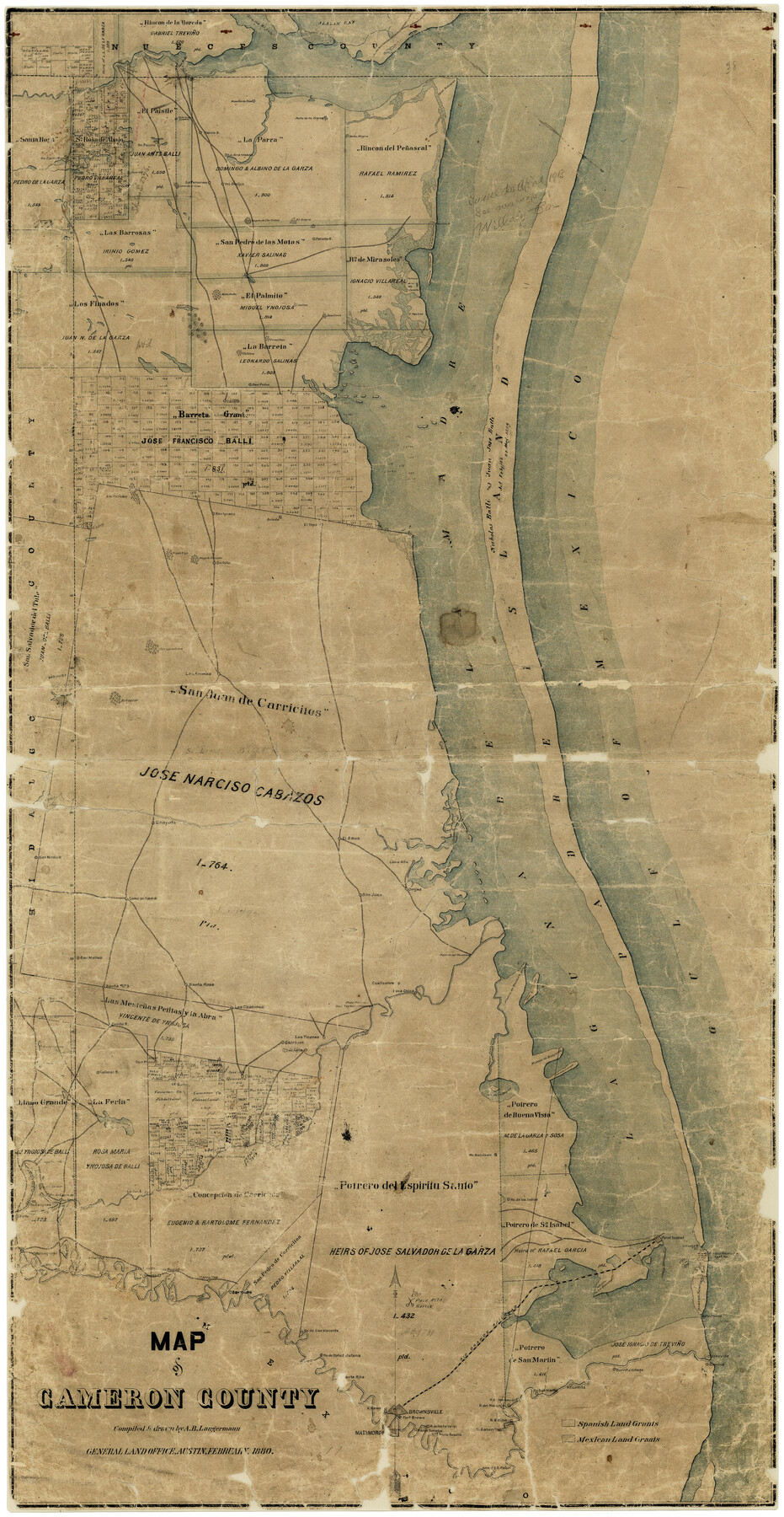
Map of Cameron County
-
Map/Doc
4786
-
Collection
General Map Collection
-
Object Dates
2/1880 (Creation Date)
-
People and Organizations
A.B. Langermann (Draftsman)
-
Counties
Cameron
-
Subjects
County
-
Height x Width
50.3 x 26.5 inches
127.8 x 67.3 cm
-
Comments
Conservation funded in 2001 with donations from Darrell Shine and Nedra Foster.
-
Features
R[anch]o de los Indios
Las Rucias [Ranch]
Carricitos
Clark's Island
Point Isabel Lighthouse
Point Isabel
U. S. Lighthouse
R[anch]o de Carasos
Tampayuas [Ranch]
Tio Cano Lake
R[anch]o San Juan
La[guna] de las Bayns
Brazos Santiago Lighthouse
Fort Venago
La Feria
La[guna] Seso
Cimales [Ranch]
Rodes [Ranch]
Novio Salado
Colimal R[anch]
Cotillo R[anch]
San Pedro [Ranch]
Ojo de Agua [Ranch]
Calaboso [Ranch]
Las Tizones [Ranch]
Fort Brown
Clarksville
Santa Rosalia [Ranch]
R[ancho] de los Tomatos
Rancho de los Falcones
R[ancho] Saino
R[ancho] Sabenitas
Burrita Village
R[anch]o Lomita
R[anch]o San Martin
R[ancho] Saino
R[ancho] del Naranjo
R[ancho] de los Sauses
Arroyo Colorado
Brownsville
R[ancho] Ramer
[S]anta Rita [Ranch]
R[anch]o de Doña Estafana
RGRR
Boca Chica
Potrero de los Blancos
Palo Alto Battle
R[anch]o de San Vincente
San Ysidro
Relamjargo [Ranch]
Palmito R[anch]
Gulf of Mexico
San Pedro
P[otrero] Favias
P[otrero] Canelos
Portreo [sic] Lopeña
La[guna] Del Mesquite
Indios
San Juan
Potrero de la Cancla
Potrero Cortado
Salt Lake
Mota Rata
San Ignacio
Atascosa B[ayou]
Mota Negra
Mota de la Garza
Nombre de Dios [Ranch]
Parra R[anch]
Mota de las Trancos
Paso del Mesquite
Paso Ancho
Paso Diso Landing
Point Penascal
Alazan Bay
San Matias [Ranch]
Bayou Atascoso
Portrero [sic] Largo
Rincon de Guajardo
Isla Cretado
Rincon de Buena Vista
Boca Chica
Cuatizones [Ranch]
General Taylor's Crossing
Paso Real
Las Chatones [Ranch]
Santa Rosa [Ranch]
Santa Rita [Ranch]
Grullo Bayou
Raymondville
Paso de Las Tavernas
Loma Alta [Ranch]
Ovejas [Ranch]
San Juan
El Saus [Ranch]
Chapote [Ranch]
Las Animas
Mogote Sarindo
Mogote Viejo
Saltillo
Part of: General Map Collection
Duval County Boundary File 3d

Print $8.00
- Digital $50.00
Duval County Boundary File 3d
Size 14.2 x 8.8 inches
Map/Doc 52738
Liberty County Sketch File 28

Print $6.00
- Digital $50.00
Liberty County Sketch File 28
Size 5.2 x 8.0 inches
Map/Doc 29952
Bailey County Sketch File 16

Print $8.00
- Digital $50.00
Bailey County Sketch File 16
1941
Size 14.2 x 8.7 inches
Map/Doc 13977
Map of the Houston and G. N. R.R. and lands adjacent, from Troupe to the Texas Pacific R.R.

Print $40.00
- Digital $50.00
Map of the Houston and G. N. R.R. and lands adjacent, from Troupe to the Texas Pacific R.R.
Size 21.2 x 92.0 inches
Map/Doc 64627
Liberty County Sketch File 46

Print $42.00
- Digital $50.00
Liberty County Sketch File 46
1860
Size 13.4 x 12.2 inches
Map/Doc 30005
Cherokee County Sketch File 29

Print $2.00
- Digital $50.00
Cherokee County Sketch File 29
Size 12.9 x 8.2 inches
Map/Doc 18175
Pecos County Sketch File 95

Print $6.00
- Digital $50.00
Pecos County Sketch File 95
1956
Size 11.2 x 8.8 inches
Map/Doc 33995
Jefferson County Working Sketch Graphic Index

Print $20.00
- Digital $50.00
Jefferson County Working Sketch Graphic Index
1978
Size 47.1 x 41.4 inches
Map/Doc 76595
Flight Mission No. DQN-5K, Frame 58, Calhoun County

Print $20.00
- Digital $50.00
Flight Mission No. DQN-5K, Frame 58, Calhoun County
1953
Size 15.5 x 15.3 inches
Map/Doc 84401
Jeff Davis County Rolled Sketch 28

Print $20.00
- Digital $50.00
Jeff Davis County Rolled Sketch 28
1977
Size 41.0 x 30.5 inches
Map/Doc 6376
Chambers County Sketch File 10

Print $4.00
- Digital $50.00
Chambers County Sketch File 10
1869
Size 6.8 x 11.1 inches
Map/Doc 17550
Burleson County Working Sketch 20

Print $20.00
- Digital $50.00
Burleson County Working Sketch 20
1980
Size 19.5 x 16.6 inches
Map/Doc 67739
You may also like
Pecos County Sketch File 78

Print $6.00
- Digital $50.00
Pecos County Sketch File 78
1943
Size 11.1 x 8.8 inches
Map/Doc 33911
Throckmorton County Sketch File 5a

Print $22.00
- Digital $50.00
Throckmorton County Sketch File 5a
Size 8.0 x 7.8 inches
Map/Doc 38075
Young County Sketch File 9

Print $4.00
- Digital $50.00
Young County Sketch File 9
1859
Size 8.5 x 7.8 inches
Map/Doc 40864
Hopkins County Sketch File 23

Print $4.00
- Digital $50.00
Hopkins County Sketch File 23
1871
Size 12.6 x 8.4 inches
Map/Doc 26732
Eastland County Working Sketch 31

Print $20.00
- Digital $50.00
Eastland County Working Sketch 31
1955
Size 33.9 x 33.9 inches
Map/Doc 68812
Zapata County Sketch File 12a

Print $42.00
- Digital $50.00
Zapata County Sketch File 12a
1921
Size 11.2 x 8.7 inches
Map/Doc 40949
Dimmit County Rolled Sketch CHM

Print $20.00
- Digital $50.00
Dimmit County Rolled Sketch CHM
1935
Size 38.4 x 43.4 inches
Map/Doc 8795
Borden County Working Sketch of Geo. Spiller's Resurvey of Block 97 made in 1887

Print $3.00
- Digital $50.00
Borden County Working Sketch of Geo. Spiller's Resurvey of Block 97 made in 1887
1903
Size 10.1 x 16.6 inches
Map/Doc 90211

Knox County Sketch File 6A

Print $20.00
- Digital $50.00
Knox County Sketch File 6A
1881
Size 32.3 x 18.2 inches
Map/Doc 11954
Flight Mission No. DAG-23K, Frame 174, Matagorda County

Print $20.00
- Digital $50.00
Flight Mission No. DAG-23K, Frame 174, Matagorda County
1953
Size 18.5 x 22.3 inches
Map/Doc 86512
The Republic County of Victoria. Proposed, Late Fall 1837-September 18, 1838

Print $20.00
The Republic County of Victoria. Proposed, Late Fall 1837-September 18, 1838
2020
Size 22.5 x 21.7 inches
Map/Doc 96295