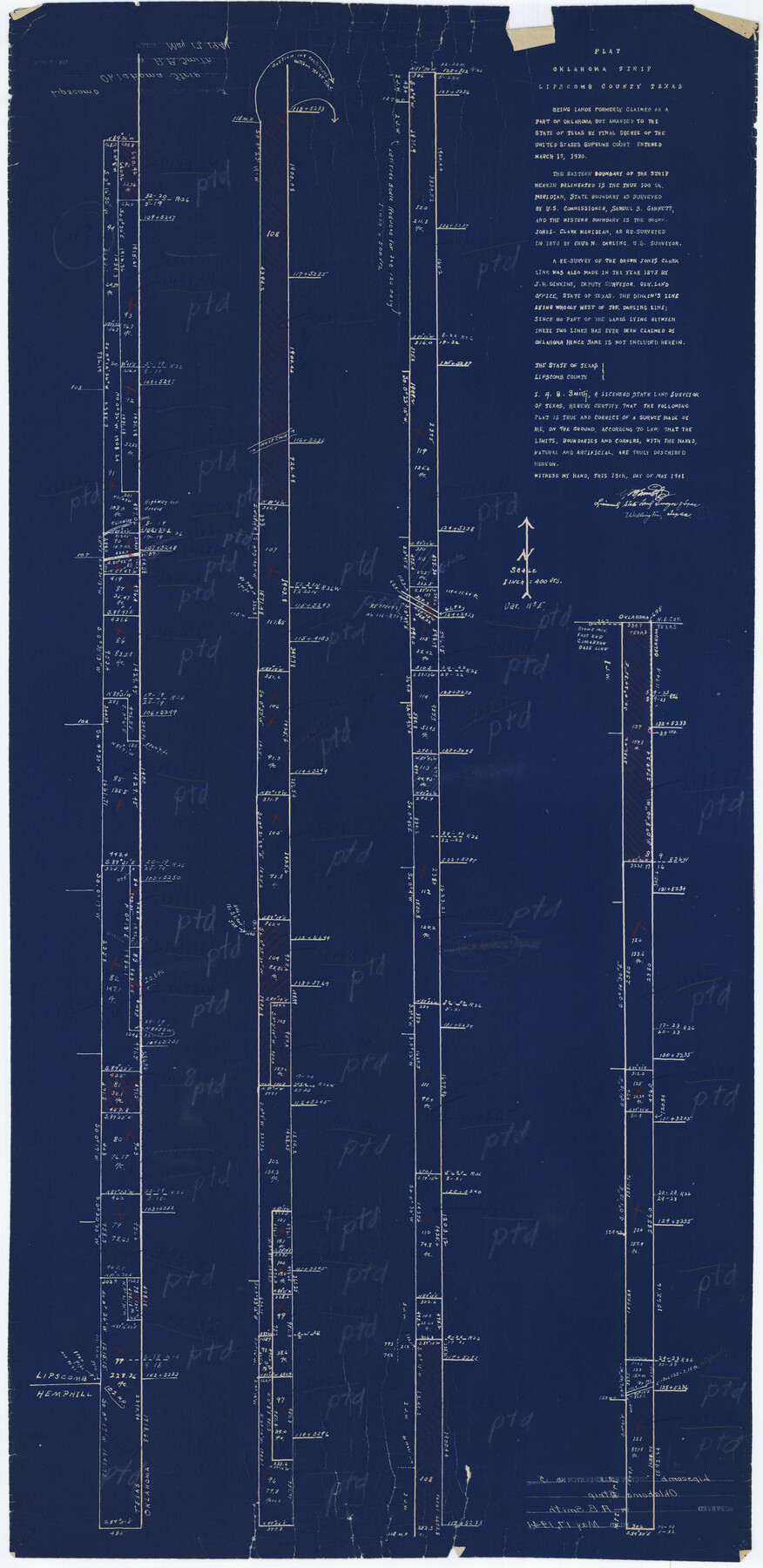
Lipscomb County Rolled Sketch 6
Plat, Oklahoma Strip, Lipscomb County, Texas
-
Map/Doc
42260
-
Collection
General Map Collection
-
Object Dates
1948/3/29 (File Date)
1941/5/13 (Creation Date)
-
People and Organizations
A.B. Smith (Surveyor/Engineer)
-
Counties
Lipscomb
-
Subjects
Surveying Rolled Sketch
-
Height x Width
44.8 x 21.8 inches
113.8 x 55.4 cm
-
Medium
blueprint/diazo
-
Scale
1" = 400 varas
Part of: General Map Collection
Live Oak County Boundary File 60b

Print $10.00
- Digital $50.00
Live Oak County Boundary File 60b
Size 12.8 x 8.3 inches
Map/Doc 56416
Harrison County Sketch File 12

Print $20.00
- Digital $50.00
Harrison County Sketch File 12
Size 21.5 x 24.1 inches
Map/Doc 11687
Map of the City of Aransas Pass

Print $20.00
- Digital $50.00
Map of the City of Aransas Pass
Size 24.0 x 26.2 inches
Map/Doc 6871
Flight Mission No. DQO-8K, Frame 49, Galveston County

Print $20.00
- Digital $50.00
Flight Mission No. DQO-8K, Frame 49, Galveston County
1952
Size 18.7 x 22.3 inches
Map/Doc 85156
Flight Mission No. CGI-3N, Frame 132, Cameron County

Print $20.00
- Digital $50.00
Flight Mission No. CGI-3N, Frame 132, Cameron County
1954
Size 18.4 x 22.2 inches
Map/Doc 84605
Leon County Rolled Sketch 4

Print $20.00
- Digital $50.00
Leon County Rolled Sketch 4
1947
Size 34.6 x 35.4 inches
Map/Doc 9426
Flight Mission No. DQN-5K, Frame 40, Calhoun County

Print $20.00
- Digital $50.00
Flight Mission No. DQN-5K, Frame 40, Calhoun County
1953
Size 18.6 x 22.1 inches
Map/Doc 84388
Mills County Boundary File 4

Print $40.00
- Digital $50.00
Mills County Boundary File 4
Size 52.1 x 13.3 inches
Map/Doc 57293
Navasota River, Springfield Sheet

Print $20.00
- Digital $50.00
Navasota River, Springfield Sheet
1934
Size 41.5 x 37.8 inches
Map/Doc 65074
Leon County Rolled Sketch 29

Print $20.00
- Digital $50.00
Leon County Rolled Sketch 29
1992
Size 34.6 x 32.9 inches
Map/Doc 6612
Parker County Rolled Sketch 2

Print $20.00
- Digital $50.00
Parker County Rolled Sketch 2
Size 32.4 x 19.6 inches
Map/Doc 7203
Harris County Rolled Sketch WDC

Print $40.00
- Digital $50.00
Harris County Rolled Sketch WDC
1936
Size 42.7 x 68.4 inches
Map/Doc 9126
You may also like
Hardin County Sketch File Q-11

Print $20.00
- Digital $50.00
Hardin County Sketch File Q-11
1937
Size 19.9 x 23.8 inches
Map/Doc 11645
Flight Mission No. DIX-5P, Frame 102, Aransas County

Print $20.00
- Digital $50.00
Flight Mission No. DIX-5P, Frame 102, Aransas County
1956
Size 17.7 x 18.0 inches
Map/Doc 83780
Laguna Madre, Register No. 1477B

Print $40.00
- Digital $50.00
Laguna Madre, Register No. 1477B
1880
Size 33.4 x 56.6 inches
Map/Doc 73607

Dimmit County Boundary File 1

Print $8.00
- Digital $50.00
Dimmit County Boundary File 1
Size 12.9 x 7.9 inches
Map/Doc 52560
Gregg County Rolled Sketch 20

Print $20.00
- Digital $50.00
Gregg County Rolled Sketch 20
1957
Size 34.6 x 44.7 inches
Map/Doc 6478
[Sketch of surveys in the Bexar District along the Pedernales River]
![103, [Sketch of surveys in the Bexar District along the Pedernales River], General Map Collection](https://historictexasmaps.com/wmedia_w700/maps/103-1.tif.jpg)
Print $2.00
- Digital $50.00
[Sketch of surveys in the Bexar District along the Pedernales River]
1847
Size 13.6 x 8.3 inches
Map/Doc 103
Mitchell's New Intermediate Geography (Louisiana Edition)

Print $819.00
- Digital $50.00
Mitchell's New Intermediate Geography (Louisiana Edition)
1885
Size 12.5 x 10.0 inches
Map/Doc 93509
Wilson County Rolled Sketch 4

Print $20.00
- Digital $50.00
Wilson County Rolled Sketch 4
Size 27.1 x 29.6 inches
Map/Doc 8370
Flight Mission No. DQN-3K, Frame 50, Calhoun County

Print $20.00
- Digital $50.00
Flight Mission No. DQN-3K, Frame 50, Calhoun County
1953
Size 18.4 x 22.2 inches
Map/Doc 84351
Falls County Boundary File 1a

Print $56.00
- Digital $50.00
Falls County Boundary File 1a
1888
Size 14.6 x 9.2 inches
Map/Doc 53253
Sterling County

Print $20.00
- Digital $50.00
Sterling County
1891
Size 23.2 x 17.7 inches
Map/Doc 4056