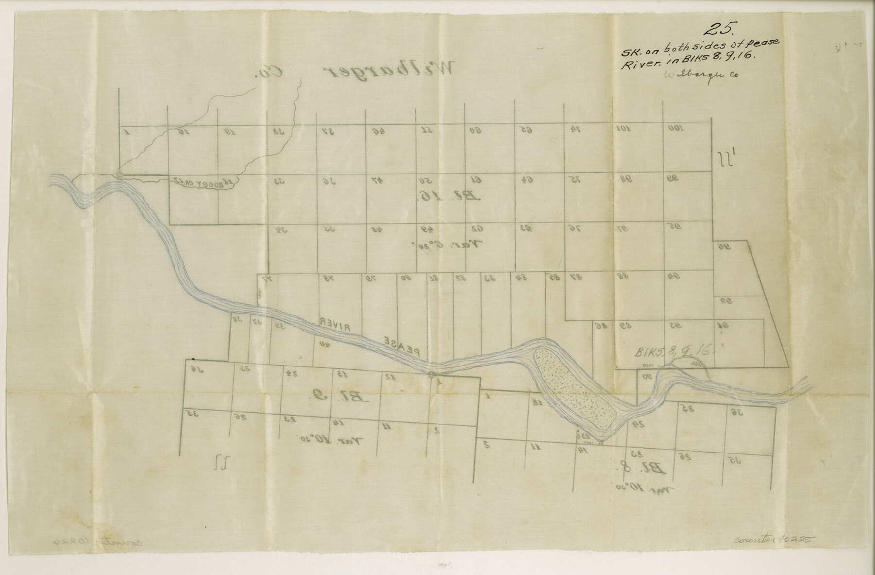
Wilbarger County Sketch File 25
[Sketch of surveys in H. & T. C. R.R. Co. Blocks 8, 9, and 16 north and south of the Pease River in the western part of the county]
-
Map/Doc
40225
-
Collection
General Map Collection
-
Counties
Wilbarger Hardeman Foard
-
Subjects
Surveying Sketch File
-
Height x Width
11.0 x 16.7 inches
27.9 x 42.4 cm
-
Medium
paper, manuscript
-
Features
Pease River
Boggy Creek
Part of: General Map Collection
San Patricio County Working Sketch 11

Print $20.00
- Digital $50.00
San Patricio County Working Sketch 11
1948
Size 34.7 x 31.3 inches
Map/Doc 63773
Flight Mission No. CGI-3N, Frame 173, Cameron County

Print $20.00
- Digital $50.00
Flight Mission No. CGI-3N, Frame 173, Cameron County
1954
Size 18.5 x 22.3 inches
Map/Doc 84637
Pecos County Working Sketch 56

Print $40.00
- Digital $50.00
Pecos County Working Sketch 56
1949
Size 29.9 x 57.4 inches
Map/Doc 71528
Matagorda County Sketch File 11

Print $6.00
- Digital $50.00
Matagorda County Sketch File 11
1885
Size 9.7 x 6.2 inches
Map/Doc 30768
Brewster County Rolled Sketch 59

Print $20.00
- Digital $50.00
Brewster County Rolled Sketch 59
1938
Size 32.8 x 45.2 inches
Map/Doc 8483
Angelina County Sketch File 2

Print $2.00
- Digital $50.00
Angelina County Sketch File 2
Size 8.6 x 6.0 inches
Map/Doc 12921
Dickens County Working Sketch 5

Print $20.00
- Digital $50.00
Dickens County Working Sketch 5
1914
Size 30.6 x 20.8 inches
Map/Doc 68652
Flight Mission No. CRE-1R, Frame 129, Jackson County

Print $20.00
- Digital $50.00
Flight Mission No. CRE-1R, Frame 129, Jackson County
1956
Size 18.5 x 22.3 inches
Map/Doc 85337
Milam County Working Sketch 12

Print $40.00
- Digital $50.00
Milam County Working Sketch 12
Size 44.3 x 56.4 inches
Map/Doc 71027
Hunt County Sketch File 28

Print $4.00
- Digital $50.00
Hunt County Sketch File 28
1860
Size 8.5 x 8.2 inches
Map/Doc 27128
Galveston County Sketch File 73h

Print $20.00
- Digital $50.00
Galveston County Sketch File 73h
Size 29.4 x 36.8 inches
Map/Doc 10461
Nueces County Rolled Sketch 6
Print $20.00
- Digital $50.00
Nueces County Rolled Sketch 6
Size 37.8 x 22.2 inches
Map/Doc 6867
You may also like
Colorado County Sketch File 20

Print $6.00
- Digital $50.00
Colorado County Sketch File 20
Size 6.0 x 7.6 inches
Map/Doc 18954
Pecos County Sketch File 84

Print $4.00
- Digital $50.00
Pecos County Sketch File 84
1944
Size 11.2 x 8.8 inches
Map/Doc 33953
Travis County Rolled Sketch 13

Print $20.00
- Digital $50.00
Travis County Rolled Sketch 13
Size 28.0 x 20.4 inches
Map/Doc 8016
Knox County Sketch File 10

Print $20.00
- Digital $50.00
Knox County Sketch File 10
1889
Size 20.1 x 12.8 inches
Map/Doc 11958
[Sketch for Mineral Application 27669 - Trinity River, Frank R. Graves]
![2861, [Sketch for Mineral Application 27669 - Trinity River, Frank R. Graves], General Map Collection](https://historictexasmaps.com/wmedia_w700/maps/2861-1.tif.jpg)
Print $40.00
- Digital $50.00
[Sketch for Mineral Application 27669 - Trinity River, Frank R. Graves]
1934
Size 27.4 x 61.6 inches
Map/Doc 2861
Pecos County Working Sketch 36

Print $20.00
- Digital $50.00
Pecos County Working Sketch 36
1939
Size 47.4 x 38.8 inches
Map/Doc 71508
Harris County Working Sketch 109

Print $20.00
- Digital $50.00
Harris County Working Sketch 109
1981
Size 21.4 x 27.2 inches
Map/Doc 66001
Irion County Sketch File 3

Print $20.00
- Digital $50.00
Irion County Sketch File 3
1891
Size 22.4 x 22.1 inches
Map/Doc 11823
Cochran County Working Sketch 4

Print $20.00
- Digital $50.00
Cochran County Working Sketch 4
1984
Size 37.7 x 24.8 inches
Map/Doc 68015

Sketch of a portion of the Texas Coast showing the relative positions of different harbours with the interior Military Posts, and the roads communicating with them, also two new routes from Black Point and Lamar to San Antonio

Print $20.00
- Digital $50.00
Sketch of a portion of the Texas Coast showing the relative positions of different harbours with the interior Military Posts, and the roads communicating with them, also two new routes from Black Point and Lamar to San Antonio
1855
Size 27.3 x 18.3 inches
Map/Doc 72709
Reference Book of Burnet's, [Vehlein's] & Zavala's Colonies
![94554, Reference Book of Burnet's, [Vehlein's] & Zavala's Colonies, Historical Volumes](https://historictexasmaps.com/wmedia_w700/pdf_converted_jpg/qi_pdf_thumbnail_39143.jpg)
Reference Book of Burnet's, [Vehlein's] & Zavala's Colonies
Map/Doc 94554