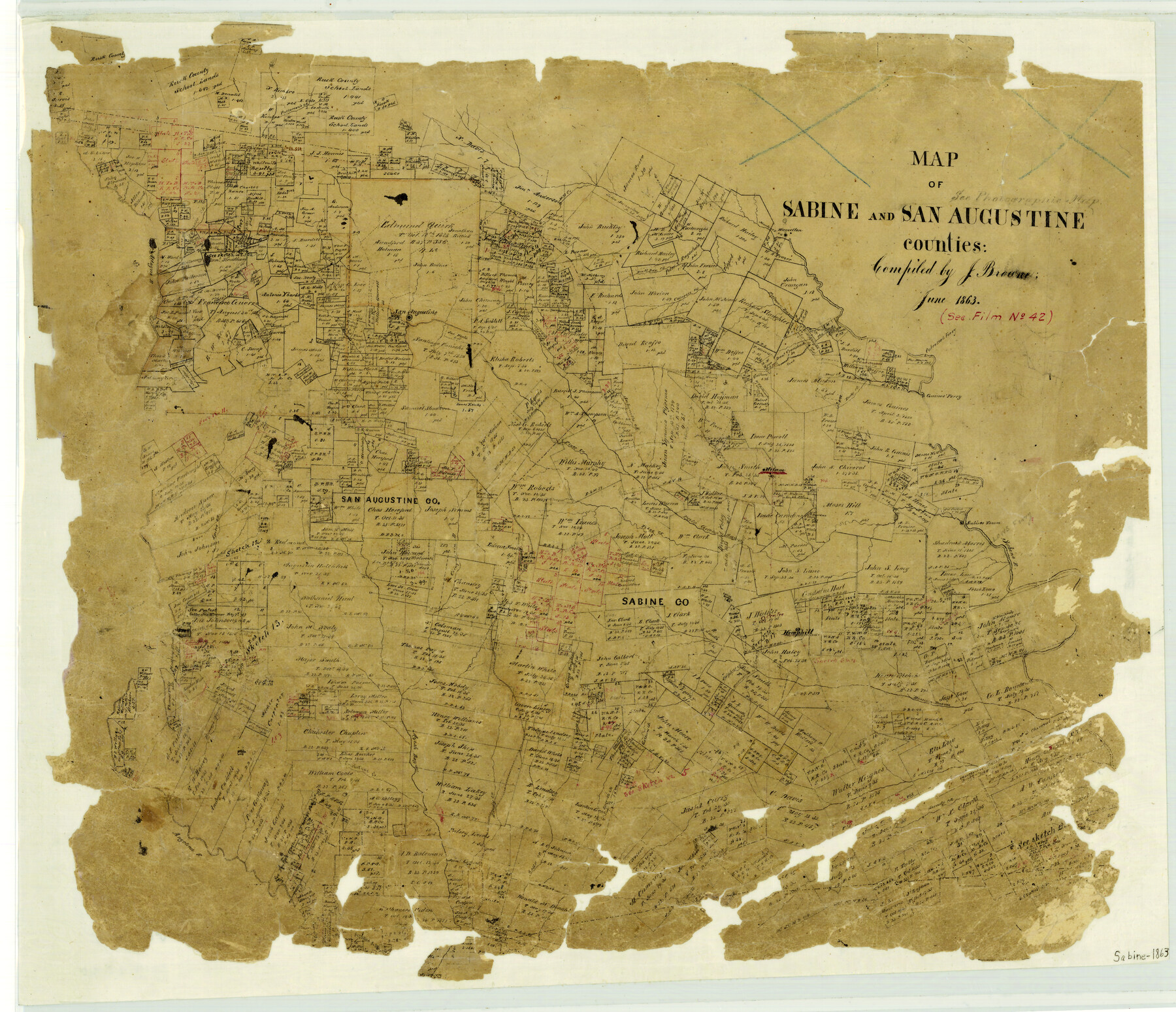
Map of Sabine and San Augustine Counties
-
Map/Doc
4008
-
Collection
General Map Collection
-
Object Dates
1863 (Creation Date)
-
People and Organizations
J. Browne (Compiler)
-
Counties
San Augustine Sabine
-
Subjects
County
-
Height x Width
20.4 x 23.7 inches
51.8 x 60.2 cm
-
Features
Carrott's Creek
Palo Gaucho Bayou
Teboe Creek
Chinquapin Bayou
Spier's Creek
Sulphur Creek
Hurricane Creek
Camp Creek
Housan Bayou
Six Miles Creek
Gallion's Creek
Hemphill
Deer Creek
Ayish Bayou
Crachatana [sic] Creek
Angelina River
Bear Creek
Sandy Creek
Bluff Creek
Dadrago Creek
Harvey's Bayou
Gaines Ferry
Hamilton
Martinez Creek
Mill Creek
Arenoso Creek
Attoyac River
Horsepen Creek
San Augustine
Bull Bay Creek
Coleroa Creek
Patroon Bayou
Patterson's Creek
Paterson's Ferry
Rocky Creek
Foards Creek
Tiger Creek
Sabanillo Creek
Milam
Sabine River
Sabine Town
Lows Ferry
Part of: General Map Collection
Dallam County Working Sketch 1

Print $20.00
- Digital $50.00
Dallam County Working Sketch 1
1905
Size 15.9 x 13.6 inches
Map/Doc 68586
Falls County Sketch File 11b

Print $4.00
- Digital $50.00
Falls County Sketch File 11b
1871
Size 10.4 x 8.5 inches
Map/Doc 22362
Flight Mission No. DQN-5K, Frame 149, Calhoun County

Print $20.00
- Digital $50.00
Flight Mission No. DQN-5K, Frame 149, Calhoun County
1953
Size 18.5 x 22.2 inches
Map/Doc 84424
Rio Grande, Hargill Sheet

Print $20.00
- Digital $50.00
Rio Grande, Hargill Sheet
1937
Size 37.3 x 37.8 inches
Map/Doc 65109
Layout of the porciones as described in the Visita General of Mier, 1767

Layout of the porciones as described in the Visita General of Mier, 1767
2009
Size 11.0 x 8.5 inches
Map/Doc 94043
Jackson County Sketch File 8

Print $20.00
- Digital $50.00
Jackson County Sketch File 8
Size 30.5 x 35.7 inches
Map/Doc 10503
Comal County Working Sketch 15

Print $20.00
- Digital $50.00
Comal County Working Sketch 15
1994
Size 44.6 x 31.0 inches
Map/Doc 68181
Hudspeth County Rolled Sketch 17

Print $40.00
- Digital $50.00
Hudspeth County Rolled Sketch 17
1886
Size 22.3 x 118.5 inches
Map/Doc 9203
Goliad County Sketch File 31

Print $6.00
- Digital $50.00
Goliad County Sketch File 31
1897
Size 10.7 x 8.2 inches
Map/Doc 24329
Erath County Sketch File 9

Print $4.00
- Digital $50.00
Erath County Sketch File 9
1870
Size 8.2 x 8.4 inches
Map/Doc 22273
Map of the Straits of Florida and Gulf of Mexico

Print $20.00
- Digital $50.00
Map of the Straits of Florida and Gulf of Mexico
1851
Size 18.3 x 27.4 inches
Map/Doc 72675
Schleicher County Rolled Sketch 10

Print $20.00
- Digital $50.00
Schleicher County Rolled Sketch 10
Size 30.1 x 25.8 inches
Map/Doc 7753
You may also like
[Block 1 Showing County Seat]
![92951, [Block 1 Showing County Seat], Twichell Survey Records](https://historictexasmaps.com/wmedia_w700/maps/92951-1.tif.jpg)
Print $20.00
- Digital $50.00
[Block 1 Showing County Seat]
Size 20.8 x 12.3 inches
Map/Doc 92951
Kleberg County Boundary File 3

Print $10.00
- Digital $50.00
Kleberg County Boundary File 3
Size 9.5 x 6.1 inches
Map/Doc 64981
Kleberg County Rolled Sketch 10-12

Print $20.00
- Digital $50.00
Kleberg County Rolled Sketch 10-12
1951
Size 38.8 x 34.9 inches
Map/Doc 9371
Refugio County Sketch File 24

Print $12.00
- Digital $50.00
Refugio County Sketch File 24
1954
Size 14.4 x 8.9 inches
Map/Doc 35283
Scurry County Rolled Sketch 2A

Print $20.00
- Digital $50.00
Scurry County Rolled Sketch 2A
Size 25.6 x 24.2 inches
Map/Doc 7764
Zavala County Boundary File 2

Print $36.00
- Digital $50.00
Zavala County Boundary File 2
Size 9.2 x 4.3 inches
Map/Doc 60239
Mason County Sketch File 11

Print $8.00
- Digital $50.00
Mason County Sketch File 11
1883
Size 13.5 x 8.6 inches
Map/Doc 30695
[South Center of County near surveys 1144 and 1143]
![90502, [South Center of County near surveys 1144 and 1143], Twichell Survey Records](https://historictexasmaps.com/wmedia_w700/maps/90502-1.tif.jpg)
Print $2.00
- Digital $50.00
[South Center of County near surveys 1144 and 1143]
Size 6.6 x 16.1 inches
Map/Doc 90502
Limestone County Sketch File 19

Print $4.00
- Digital $50.00
Limestone County Sketch File 19
1922
Size 11.0 x 8.7 inches
Map/Doc 30193
Waller County Working Sketch 7

Print $20.00
- Digital $50.00
Waller County Working Sketch 7
2000
Size 34.6 x 41.5 inches
Map/Doc 72306
Hamilton County Working Sketch 1

Print $20.00
- Digital $50.00
Hamilton County Working Sketch 1
1914
Size 17.7 x 17.8 inches
Map/Doc 63339
[Missouri, Kansas & Texas Line Map through Bastrop County]
![64032, [Missouri, Kansas & Texas Line Map through Bastrop County], General Map Collection](https://historictexasmaps.com/wmedia_w700/maps/64032.tif.jpg)
Print $40.00
- Digital $50.00
[Missouri, Kansas & Texas Line Map through Bastrop County]
1916
Size 25.4 x 106.0 inches
Map/Doc 64032