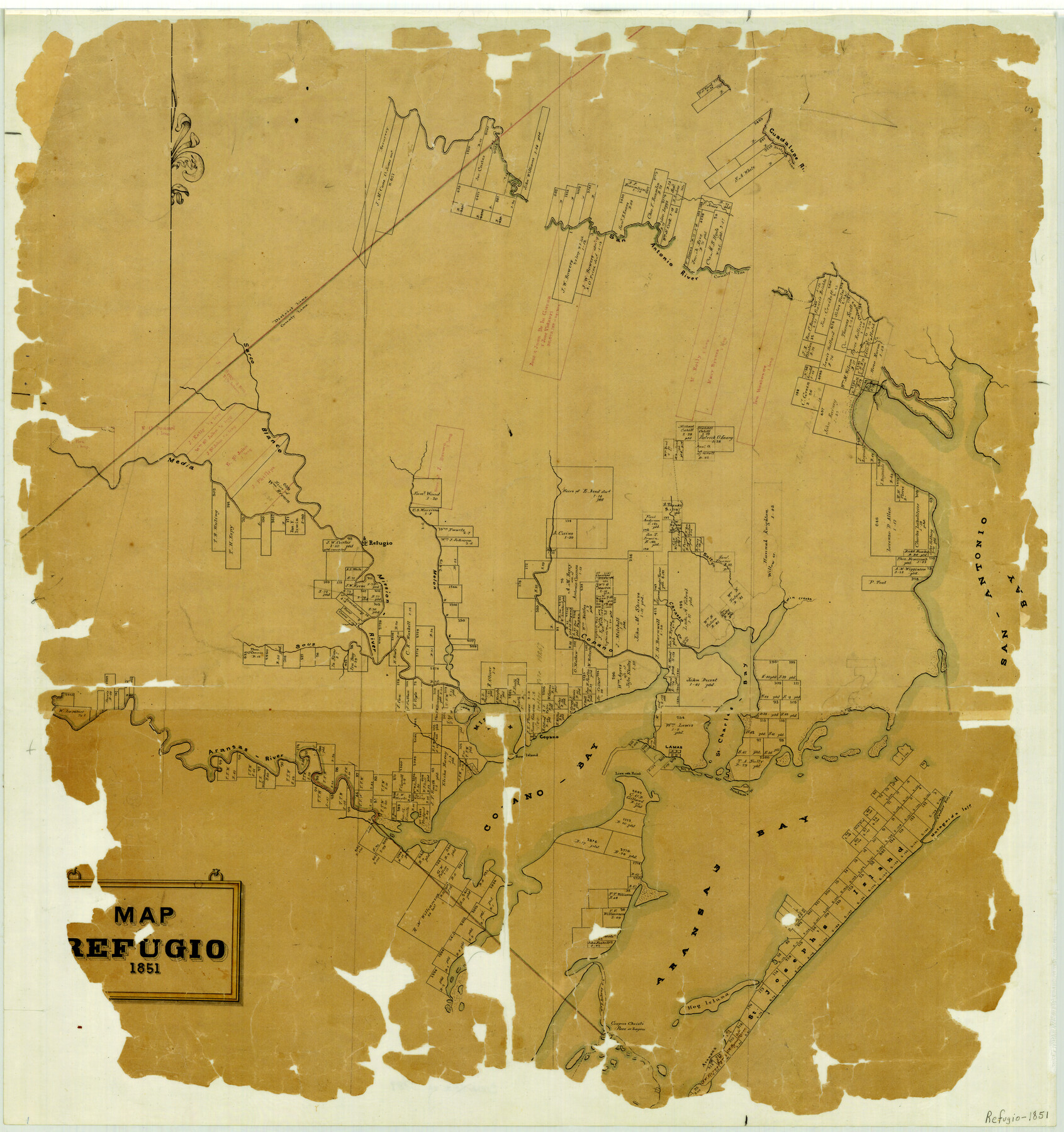
Map of Refugio
-
Map/Doc
3989
-
Collection
General Map Collection
-
Object Dates
1851 (Creation Date)
-
People and Organizations
Texas General Land Office (Publisher)
-
Counties
Refugio
-
Subjects
County
-
Height x Width
27.2 x 25.6 inches
69.1 x 65.0 cm
-
Features
Mission Bay
Aransas
Hog Island
Corpus Christi Bayou
Corpus Christi Pass
Aransas Bay
Aransas River
Copano Bay
Sow Island
Live Oak Point
Dunham's Island
Matagorda Island
Cedar Bayou
Lamar
St. Charles Bay
Copano
Guadalupe River
Sous [Arroyo]
Mission River
Melon [Creek]
Copano [Creek]
Cavasso Creek
Twin Creeks
San Antonio Bay
Willow Creek
Salt Creek
Refugio
Media Creek
Sarco Blanco River
Davis Creek
Osborn's Creek
San Antonio River
Part of: General Map Collection
Map of 4th Section of 54.68 Miles East from Franklin, Rio Grande Division T. and P. Ry.

Print $40.00
- Digital $50.00
Map of 4th Section of 54.68 Miles East from Franklin, Rio Grande Division T. and P. Ry.
1881
Size 150.0 x 21.9 inches
Map/Doc 64639
Reeves County Working Sketch 12

Print $20.00
- Digital $50.00
Reeves County Working Sketch 12
1958
Size 34.2 x 24.5 inches
Map/Doc 63455
Nueces County Rolled Sketch 87

Print $20.00
- Digital $50.00
Nueces County Rolled Sketch 87
1983
Size 24.2 x 36.9 inches
Map/Doc 6989
Wilbarger County Sketch File 29

Print $18.00
- Digital $50.00
Wilbarger County Sketch File 29
2016
Size 11.0 x 8.5 inches
Map/Doc 95325
Brewster County Rolled Sketch 155

Print $20.00
- Digital $50.00
Brewster County Rolled Sketch 155
Size 36.8 x 24.7 inches
Map/Doc 78343
Parker County Sketch File 30

Print $4.00
- Digital $50.00
Parker County Sketch File 30
Size 6.4 x 7.0 inches
Map/Doc 33570
Runnels County Sketch File 33

Print $20.00
Runnels County Sketch File 33
1892
Size 19.1 x 23.1 inches
Map/Doc 12264
Coast Chart No. 212 - From Latitude 26° 33' to the Rio Grande Texas

Print $20.00
- Digital $50.00
Coast Chart No. 212 - From Latitude 26° 33' to the Rio Grande Texas
1886
Size 27.7 x 18.2 inches
Map/Doc 72827


Flight Mission No. BQY-4M, Frame 68, Harris County

Print $20.00
- Digital $50.00
Flight Mission No. BQY-4M, Frame 68, Harris County
1953
Size 18.6 x 22.4 inches
Map/Doc 85277
Brazoria County State Real Property Sketch 1

Print $20.00
- Digital $50.00
Brazoria County State Real Property Sketch 1
1997
Size 24.4 x 34.8 inches
Map/Doc 80127
You may also like
Edwards County Working Sketch 7

Print $20.00
- Digital $50.00
Edwards County Working Sketch 7
1918
Size 34.6 x 29.7 inches
Map/Doc 68883
Eastland County Working Sketch 54

Print $20.00
- Digital $50.00
Eastland County Working Sketch 54
1984
Size 19.6 x 18.0 inches
Map/Doc 68835
Traced from Genl. Arista's map captured by the American Army under Genl. Taylor at Resaca de la Palma 9th May '46 and presented to James K. Polk, President U. States

Print $20.00
- Digital $50.00
Traced from Genl. Arista's map captured by the American Army under Genl. Taylor at Resaca de la Palma 9th May '46 and presented to James K. Polk, President U. States
1846
Size 18.2 x 27.3 inches
Map/Doc 73060
Crockett County Rolled Sketch 88A

Print $20.00
- Digital $50.00
Crockett County Rolled Sketch 88A
Size 29.9 x 18.6 inches
Map/Doc 5627
Railroad Track Map, H&TCRRCo., Falls County, Texas

Print $4.00
- Digital $50.00
Railroad Track Map, H&TCRRCo., Falls County, Texas
1918
Size 11.4 x 18.7 inches
Map/Doc 62849
W. D. Twichell's R. S. Hunnicutt's Resurvey in Oldham County, Texas June to November, 1915

Print $40.00
- Digital $50.00
W. D. Twichell's R. S. Hunnicutt's Resurvey in Oldham County, Texas June to November, 1915
1915
Size 71.3 x 42.6 inches
Map/Doc 89799
Flight Mission No. DAG-22K, Frame 83, Matagorda County

Print $20.00
- Digital $50.00
Flight Mission No. DAG-22K, Frame 83, Matagorda County
1953
Size 18.5 x 18.7 inches
Map/Doc 86467
Marion County Working Sketch 12a

Print $20.00
- Digital $50.00
Marion County Working Sketch 12a
1953
Size 23.9 x 33.2 inches
Map/Doc 70788
Erath County Working Sketch 33

Print $20.00
- Digital $50.00
Erath County Working Sketch 33
1972
Size 25.1 x 21.0 inches
Map/Doc 69114
Texas-Oklahoma Clara Quadrangle

Print $20.00
- Digital $50.00
Texas-Oklahoma Clara Quadrangle
1937
Size 20.3 x 16.9 inches
Map/Doc 75105
Van Zandt County Working Sketch 7

Print $20.00
- Digital $50.00
Van Zandt County Working Sketch 7
1953
Size 17.7 x 18.1 inches
Map/Doc 72257
[H. & G. N. Block 4]
![90268, [H. & G. N. Block 4], Twichell Survey Records](https://historictexasmaps.com/wmedia_w700/maps/90268-1.tif.jpg)
Print $20.00
- Digital $50.00
[H. & G. N. Block 4]
1887
Size 22.2 x 19.6 inches
Map/Doc 90268