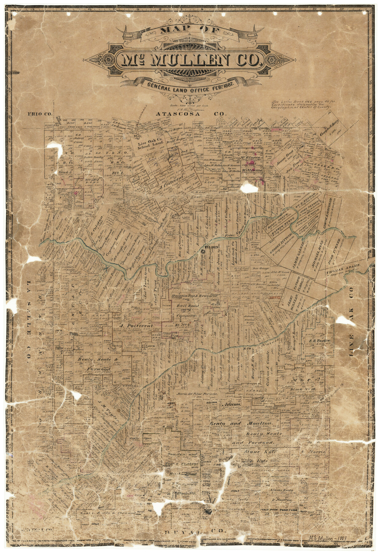
Map of McMullen County
-
Map/Doc
3866
-
Collection
General Map Collection
-
Object Dates
2/1887 (Creation Date)
-
People and Organizations
F.G. Blau (Draftsman)
-
Counties
McMullen
-
Subjects
County
-
Height x Width
26.8 x 18.6 inches
68.1 x 47.2 cm
-
Features
Willow B[ranch of Frio River]
Elm Creek
San Fernando Creek
Cow Creek
Hill Creek
Rio Nueces
Maie Creek
Guadalupe Creek
Bushy Hills
Frio Creek
San Miguel Creek
Wentz
Tilden
Leoncito Creek
Esperanxes Creek
Raw Hide Creek
Laredo Road
San Kaholi [Hill]
Frio River
San Patricio Creek
Part of: General Map Collection
Palo Pinto County Working Sketch 9

Print $20.00
- Digital $50.00
Palo Pinto County Working Sketch 9
1922
Map/Doc 71392
Sketch for Mineral Application 26543 (D. H. Sanford) - 243.37 Acres

Print $3.00
- Digital $50.00
Sketch for Mineral Application 26543 (D. H. Sanford) - 243.37 Acres
1931
Size 16.6 x 3.7 inches
Map/Doc 65679
Brazoria County NRC Article 33.136 Sketch 26

Print $24.00
Brazoria County NRC Article 33.136 Sketch 26
2025
Map/Doc 97471
Howard County Sketch File 15

Print $6.00
- Digital $50.00
Howard County Sketch File 15
Size 11.2 x 8.8 inches
Map/Doc 26875
Coke County Sketch File 8

Print $20.00
- Digital $50.00
Coke County Sketch File 8
Size 20.2 x 27.8 inches
Map/Doc 11106
Freestone County Working Sketch 3

Print $20.00
- Digital $50.00
Freestone County Working Sketch 3
1914
Size 18.8 x 16.2 inches
Map/Doc 69245
Duval County Rolled Sketch EF

Print $20.00
- Digital $50.00
Duval County Rolled Sketch EF
1934
Size 26.8 x 35.0 inches
Map/Doc 5766

Duval County Sketch File 45a

Print $9.00
- Digital $50.00
Duval County Sketch File 45a
Size 14.5 x 9.0 inches
Map/Doc 21396
Brewster County Working Sketch 118.2

Print $20.00
- Digital $50.00
Brewster County Working Sketch 118.2
Size 26.8 x 20.6 inches
Map/Doc 67871
Jeff Davis County Sketch File 30

Print $26.00
- Digital $50.00
Jeff Davis County Sketch File 30
1922
Size 14.1 x 8.5 inches
Map/Doc 28014
Culberson County Sketch File 38

Print $20.00
- Digital $50.00
Culberson County Sketch File 38
1964
Size 21.7 x 18.6 inches
Map/Doc 11274
You may also like
[Blocks T1, T2, T3, Leagues 574, 575, 634- 637

Print $20.00
- Digital $50.00
[Blocks T1, T2, T3, Leagues 574, 575, 634- 637
Size 30.2 x 33.5 inches
Map/Doc 91051
The Land Offices. No. 2, San Augustine, December 22, 1836

Print $20.00
The Land Offices. No. 2, San Augustine, December 22, 1836
2020
Size 19.7 x 18.4 inches
Map/Doc 96415
Johnson County Working Sketch 22

Print $20.00
- Digital $50.00
Johnson County Working Sketch 22
1992
Size 14.6 x 18.1 inches
Map/Doc 66635
Robertson County Sketch File 7

Print $20.00
Robertson County Sketch File 7
1873
Size 16.3 x 24.0 inches
Map/Doc 12250
Mills County Working Sketch 2

Print $20.00
- Digital $50.00
Mills County Working Sketch 2
1904
Size 12.7 x 15.8 inches
Map/Doc 71032
Navigation Maps of Gulf Intracoastal Waterway, Port Arthur to Brownsville, Texas

Print $4.00
- Digital $50.00
Navigation Maps of Gulf Intracoastal Waterway, Port Arthur to Brownsville, Texas
1951
Size 16.6 x 21.3 inches
Map/Doc 65438
Copy of Surveyor's Field Book, Morris Browning - In Blocks 7, 5 & 4, I&GNRRCo., Hutchinson and Carson Counties, Texas

Print $2.00
- Digital $50.00
Copy of Surveyor's Field Book, Morris Browning - In Blocks 7, 5 & 4, I&GNRRCo., Hutchinson and Carson Counties, Texas
1888
Size 6.9 x 8.8 inches
Map/Doc 62262
Leon County Sketch File 10

Print $64.00
- Digital $50.00
Leon County Sketch File 10
1871
Size 10.6 x 15.7 inches
Map/Doc 29731
The Chief Justice County of Red River. Lands in Conflict with Nacogdoches County

Print $20.00
The Chief Justice County of Red River. Lands in Conflict with Nacogdoches County
2020
Size 17.4 x 21.8 inches
Map/Doc 96066
Menard County Boundary File 2b

Print $6.00
- Digital $50.00
Menard County Boundary File 2b
Size 13.3 x 8.2 inches
Map/Doc 57069
Flight Mission No. DQO-8K, Frame 89, Galveston County

Print $20.00
- Digital $50.00
Flight Mission No. DQO-8K, Frame 89, Galveston County
1952
Size 18.6 x 22.4 inches
Map/Doc 85191
Fayette County Working Sketch 7

Print $20.00
- Digital $50.00
Fayette County Working Sketch 7
1981
Size 24.1 x 15.6 inches
Map/Doc 69171