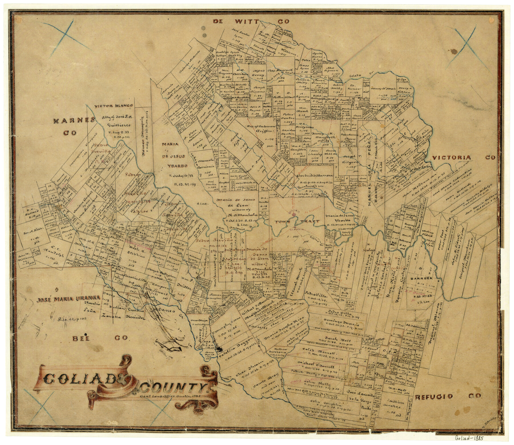
Goliad County
-
Map/Doc
3587
-
Collection
General Map Collection
-
Object Dates
1885 (Creation Date)
-
People and Organizations
Texas General Land Office (Publisher)
V. Schmidt (Draftsman)
-
Counties
Goliad
-
Subjects
County
-
Height x Width
20.0 x 23.1 inches
50.8 x 58.7 cm
-
Features
La Bahia
18 Miles Creek
La Guadalupe Road
Sarco Creek
Majerria Creek
Richland Creek
Blanco River
Miller's Creek
Cadena Creek
[Road] to Guadalupe
Refugio Road
[Road] to Mier
[Road] to Victoria
[Road] to Clinton
Hosier Creek
Goliad
San Antonio River
Hord Creek
Cabeza Creek
Manahuilla Creek
Little Perdido Creek
Kilgore Creek
Perdido Creek
Turkey Creek
Rock Creek
Coleto Creek
West Fork of 18 Miles Creek
West Fork of Coleto Creek
Part of: General Map Collection
Cass County Rolled Sketch 7

Print $20.00
- Digital $50.00
Cass County Rolled Sketch 7
1957
Size 28.3 x 33.5 inches
Map/Doc 5413
Presidio County Working Sketch 43

Print $40.00
- Digital $50.00
Presidio County Working Sketch 43
1949
Size 29.0 x 54.9 inches
Map/Doc 71720
Kenedy County Aerial Photograph Index Sheet 2

Print $20.00
- Digital $50.00
Kenedy County Aerial Photograph Index Sheet 2
1943
Size 23.1 x 19.3 inches
Map/Doc 83714
San Jacinto River, Water Sheds of the San Jacinto River and Buffalo Bayou

Print $4.00
- Digital $50.00
San Jacinto River, Water Sheds of the San Jacinto River and Buffalo Bayou
Size 28.8 x 20.0 inches
Map/Doc 65149
Liberty County Working Sketch 19

Print $20.00
- Digital $50.00
Liberty County Working Sketch 19
1940
Size 29.2 x 41.3 inches
Map/Doc 70478
Erath County Sketch File 16

Print $4.00
- Digital $50.00
Erath County Sketch File 16
1872
Size 12.9 x 8.3 inches
Map/Doc 22294
Bee County Sketch File Y

Print $4.00
- Digital $50.00
Bee County Sketch File Y
Size 8.8 x 5.4 inches
Map/Doc 14255
Mason County Working Sketch 9

Print $20.00
- Digital $50.00
Mason County Working Sketch 9
1949
Size 34.4 x 29.4 inches
Map/Doc 70845
Flight Mission No. DIX-6P, Frame 135, Aransas County

Print $20.00
- Digital $50.00
Flight Mission No. DIX-6P, Frame 135, Aransas County
1956
Size 19.5 x 23.0 inches
Map/Doc 83841
Stonewall County Rolled Sketch 20

Print $40.00
- Digital $50.00
Stonewall County Rolled Sketch 20
1951
Size 30.1 x 55.4 inches
Map/Doc 63915
Map of Asylum & University lands situated on the waters of Hubbards Creek

Print $20.00
- Digital $50.00
Map of Asylum & University lands situated on the waters of Hubbards Creek
1857
Size 21.2 x 28.5 inches
Map/Doc 2491
Presidio County Working Sketch 105

Print $20.00
- Digital $50.00
Presidio County Working Sketch 105
1980
Size 27.5 x 27.5 inches
Map/Doc 71782
You may also like


Tom Green County Boundary File 5

Print $44.00
- Digital $50.00
Tom Green County Boundary File 5
Size 14.4 x 8.8 inches
Map/Doc 59363
Bell County Sketch File 28

Print $4.00
- Digital $50.00
Bell County Sketch File 28
1870
Size 7.8 x 6.5 inches
Map/Doc 14437
Jeff Davis County Sketch File 25

Print $32.00
- Digital $50.00
Jeff Davis County Sketch File 25
1886
Size 11.3 x 8.5 inches
Map/Doc 27992
Map of the Colonization Grants to Zavala, Vehlein & Burnet in Texas, belonging to the Galveston Bay & Texas Land Co.

Print $20.00
- Digital $50.00
Map of the Colonization Grants to Zavala, Vehlein & Burnet in Texas, belonging to the Galveston Bay & Texas Land Co.
1835
Size 10.7 x 12.7 inches
Map/Doc 93851
Presidio County Sketch File 61

Print $3.00
- Digital $50.00
Presidio County Sketch File 61
1930
Size 9.3 x 15.4 inches
Map/Doc 89987
Webb County Working Sketch 64

Print $20.00
- Digital $50.00
Webb County Working Sketch 64
1962
Size 12.8 x 26.1 inches
Map/Doc 72430
Bandera County Working Sketch 10

Print $20.00
- Digital $50.00
Bandera County Working Sketch 10
1922
Size 17.9 x 19.4 inches
Map/Doc 67603
A Chart of the Internal Part of Louisiana

Print $20.00
- Digital $50.00
A Chart of the Internal Part of Louisiana
1810
Size 19.0 x 17.3 inches
Map/Doc 95155
Rio Grande, Hargill Sheet

Print $20.00
- Digital $50.00
Rio Grande, Hargill Sheet
1937
Size 37.3 x 37.8 inches
Map/Doc 65109
Flight Mission No. CUG-1P, Frame 106, Kleberg County

Print $20.00
- Digital $50.00
Flight Mission No. CUG-1P, Frame 106, Kleberg County
1956
Size 18.8 x 22.3 inches
Map/Doc 86156