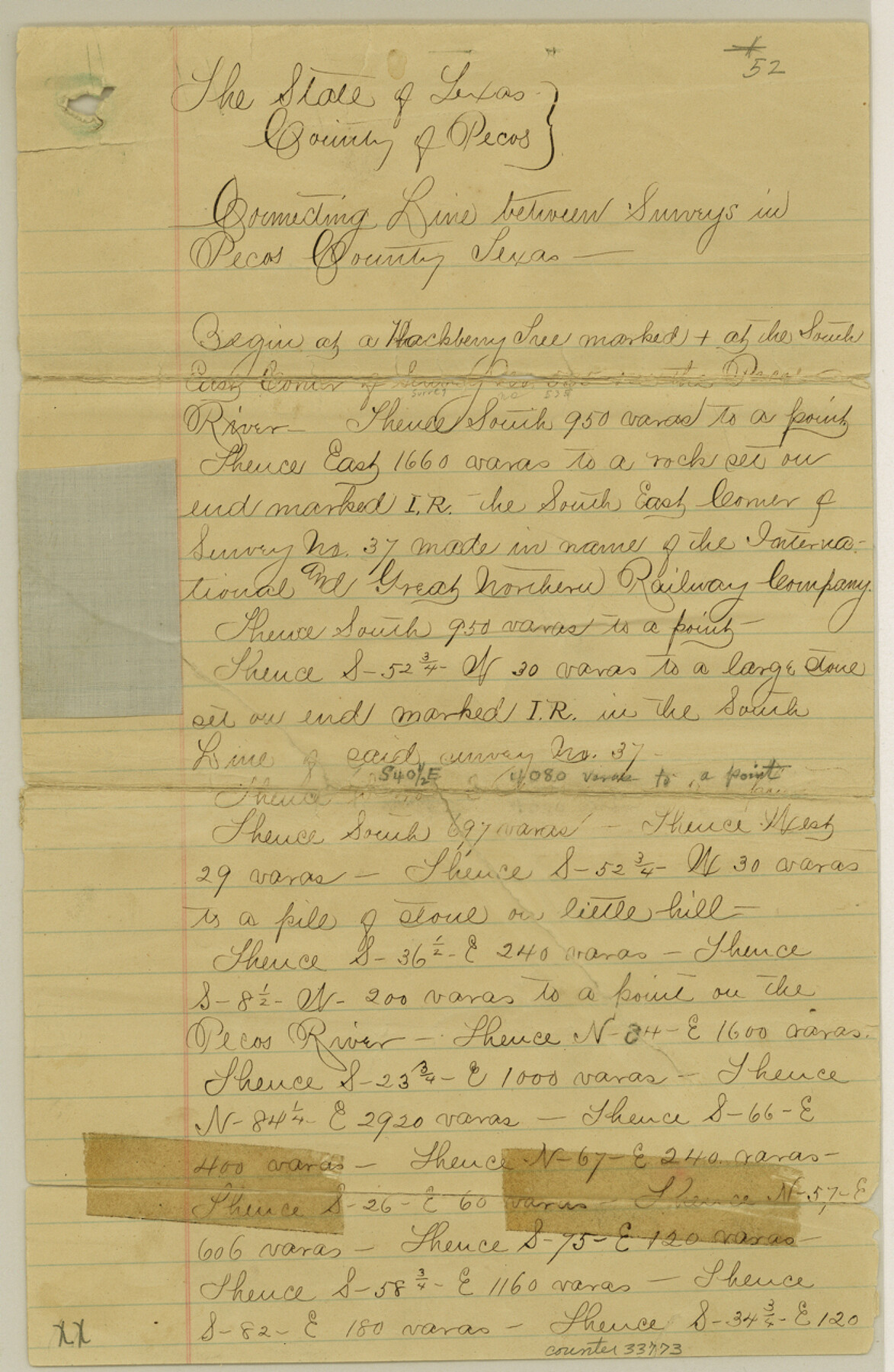
Pecos County Sketch File 51
[Miscellaneous connecting lines in Pecos County]
-
Map/Doc
33773
-
Collection
General Map Collection
-
Object Dates
1881 (Creation Date)
1882 (File Date)
1882 (Survey Date)
1882 (Survey Date)
-
People and Organizations
L.W. Durrell (Surveyor/Engineer)
-
Counties
Pecos
-
Subjects
Surveying Sketch File
-
Height x Width
12.8 x 8.4 inches
32.5 x 21.3 cm
-
Medium
paper, manuscript
-
Features
Pecos River
Independence Creek
Part of: General Map Collection
Young County Working Sketch 5

Print $20.00
- Digital $50.00
Young County Working Sketch 5
1919
Size 14.3 x 7.1 inches
Map/Doc 62028
Trinity County Sketch File 29

Print $20.00
- Digital $50.00
Trinity County Sketch File 29
1859
Size 18.1 x 37.1 inches
Map/Doc 12488
Collin County Boundary File 4 and 4a

Print $160.00
- Digital $50.00
Collin County Boundary File 4 and 4a
Size 11.9 x 8.5 inches
Map/Doc 51691
National Map Company's Ohio showing Counties, Townships, Cities, Villages, Post Offices, Steam and Electric Railways, With Stations and Distances Between Stations

Print $20.00
- Digital $50.00
National Map Company's Ohio showing Counties, Townships, Cities, Villages, Post Offices, Steam and Electric Railways, With Stations and Distances Between Stations
1920
Size 38.7 x 32.3 inches
Map/Doc 97109
Corpus Christi Pass, Texas

Print $20.00
- Digital $50.00
Corpus Christi Pass, Texas
1871
Size 26.1 x 18.2 inches
Map/Doc 72980
Stephens County Boundary File 81

Print $44.00
- Digital $50.00
Stephens County Boundary File 81
Size 9.2 x 3.8 inches
Map/Doc 58906
Flight Mission No. CRC-1R, Frame 94, Chambers County

Print $20.00
- Digital $50.00
Flight Mission No. CRC-1R, Frame 94, Chambers County
1956
Size 18.8 x 22.5 inches
Map/Doc 84709
Flight Mission No. DCL-6C, Frame 30, Kenedy County

Print $20.00
- Digital $50.00
Flight Mission No. DCL-6C, Frame 30, Kenedy County
1943
Size 18.8 x 22.3 inches
Map/Doc 85887
Orange County Boundary File 1

Print $4.00
- Digital $50.00
Orange County Boundary File 1
Size 9.7 x 6.3 inches
Map/Doc 57773
Lampasas County Sketch File 16 1/2

Print $4.00
- Digital $50.00
Lampasas County Sketch File 16 1/2
Size 8.4 x 8.6 inches
Map/Doc 29428
McCulloch County

Print $20.00
- Digital $50.00
McCulloch County
1904
Size 46.9 x 35.9 inches
Map/Doc 66922
Pecos County Boundary File 69a

Print $40.00
- Digital $50.00
Pecos County Boundary File 69a
Size 8.4 x 9.7 inches
Map/Doc 57901
You may also like
Map of Jasper District

Print $20.00
- Digital $50.00
Map of Jasper District
1847
Size 32.8 x 29.6 inches
Map/Doc 3713
Clay County Sketch File 29

Print $16.00
- Digital $50.00
Clay County Sketch File 29
Size 11.3 x 8.7 inches
Map/Doc 18448
Trinity County Sketch File 33A

Print $6.00
- Digital $50.00
Trinity County Sketch File 33A
1920
Size 6.5 x 6.8 inches
Map/Doc 38575
Gregg County Sketch File 15

Print $6.00
- Digital $50.00
Gregg County Sketch File 15
1946
Size 14.3 x 8.8 inches
Map/Doc 24616
General Highway Map, Panola County, Texas

Print $20.00
General Highway Map, Panola County, Texas
1940
Size 18.2 x 24.6 inches
Map/Doc 79214
[Aransas Bay]
![72970, [Aransas Bay], General Map Collection](https://historictexasmaps.com/wmedia_w700/maps/72970.tif.jpg)
Print $20.00
- Digital $50.00
[Aransas Bay]
1846
Size 24.3 x 18.3 inches
Map/Doc 72970
Reeves County Working Sketch 14

Print $20.00
- Digital $50.00
Reeves County Working Sketch 14
1960
Size 26.5 x 24.9 inches
Map/Doc 63457
Galveston Bay Oil Area, Galveston, Harris, Chambers and Brazoria Cos.

Print $40.00
- Digital $50.00
Galveston Bay Oil Area, Galveston, Harris, Chambers and Brazoria Cos.
1927
Size 52.9 x 40.8 inches
Map/Doc 2938
Colorado County Sketch File 3a

Print $4.00
- Digital $50.00
Colorado County Sketch File 3a
Size 8.5 x 13.3 inches
Map/Doc 18915
Cherokee County Sketch File 14

Print $4.00
- Digital $50.00
Cherokee County Sketch File 14
1860
Size 8.0 x 5.9 inches
Map/Doc 18147
Galveston County Rolled Sketch 18

Print $20.00
- Digital $50.00
Galveston County Rolled Sketch 18
1958
Size 24.1 x 32.0 inches
Map/Doc 5956
Hall County, Texas

Print $20.00
- Digital $50.00
Hall County, Texas
1880
Size 24.9 x 20.4 inches
Map/Doc 480