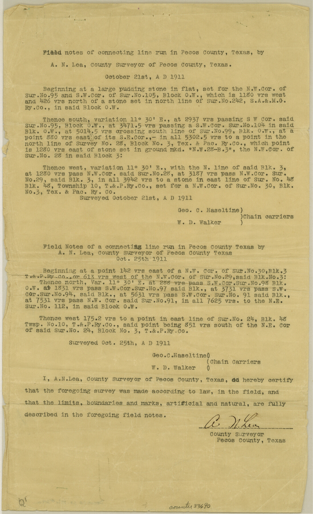
Pecos County Sketch File 29a
[Field notes of connecting line run in Pecos County]
-
Map/Doc
33690
-
Collection
General Map Collection
-
Object Dates
12/15/1911 (File Date)
10/21/1911 (Creation Date)
10/21/1911 (Survey Date)
10/25/1911 (Survey Date)
10/31/1911 (Survey Date)
11/9/1911 (Survey Date)
-
People and Organizations
A.N. Lea (Surveyor/Engineer)
George C. Haseltine (Chainman/Field Personnel)
W.D. Walker (Chainman/Field Personnel)
George Teague (Chainman/Field Personnel)
-
Counties
Pecos
-
Subjects
Surveying Sketch File
-
Height x Width
14.2 x 8.6 inches
36.1 x 21.8 cm
-
Medium
paper, print
Part of: General Map Collection
Dimmit County Sketch File 38

Print $40.00
- Digital $50.00
Dimmit County Sketch File 38
1896
Size 14.8 x 16.9 inches
Map/Doc 21163
San Jacinto County Rolled Sketch 10A

Print $40.00
- Digital $50.00
San Jacinto County Rolled Sketch 10A
1944
Size 42.9 x 59.0 inches
Map/Doc 9882
Reeves County Sketch File 17

Print $40.00
- Digital $50.00
Reeves County Sketch File 17
1943
Size 9.9 x 19.4 inches
Map/Doc 35208
Collin County

Print $20.00
- Digital $50.00
Collin County
1975
Size 42.7 x 39.8 inches
Map/Doc 95459
[Atchison, Topeka & Santa Fe from Paisano to south of Plata]
![64709, [Atchison, Topeka & Santa Fe from Paisano to south of Plata], General Map Collection](https://historictexasmaps.com/wmedia_w700/maps/64709.tif.jpg)
Print $40.00
- Digital $50.00
[Atchison, Topeka & Santa Fe from Paisano to south of Plata]
Size 32.3 x 120.8 inches
Map/Doc 64709
[Sketch for Mineral Application 24072, San Jacinto River]
![65594, [Sketch for Mineral Application 24072, San Jacinto River], General Map Collection](https://historictexasmaps.com/wmedia_w700/maps/65594.tif.jpg)
Print $20.00
- Digital $50.00
[Sketch for Mineral Application 24072, San Jacinto River]
1929
Size 25.8 x 20.8 inches
Map/Doc 65594
Presidio County Working Sketch 26

Print $20.00
- Digital $50.00
Presidio County Working Sketch 26
1945
Size 41.9 x 24.3 inches
Map/Doc 71702
El Paso County Rolled Sketch 54

Print $20.00
- Digital $50.00
El Paso County Rolled Sketch 54
1980
Size 30.4 x 42.8 inches
Map/Doc 44539

Duval County Sketch File 32b

Print $6.00
- Digital $50.00
Duval County Sketch File 32b
Size 14.2 x 8.9 inches
Map/Doc 21339
Colorado County Working Sketch 26

Print $20.00
- Digital $50.00
Colorado County Working Sketch 26
1977
Size 22.7 x 18.7 inches
Map/Doc 68126
Starr County Working Sketch 21

Print $20.00
- Digital $50.00
Starr County Working Sketch 21
Size 32.6 x 33.7 inches
Map/Doc 63937
You may also like
Flight Mission No. DIX-8P, Frame 66, Aransas County

Print $20.00
- Digital $50.00
Flight Mission No. DIX-8P, Frame 66, Aransas County
1956
Size 18.6 x 22.2 inches
Map/Doc 83897
Schleicher County Working Sketch 6

Print $20.00
- Digital $50.00
Schleicher County Working Sketch 6
Size 24.6 x 19.3 inches
Map/Doc 63808
[Gunter & Munson, Maddox Bros. & Anderson Blocks F and A and blocks south]
![91850, [Gunter & Munson, Maddox Bros. & Anderson Blocks F and A and blocks south], Twichell Survey Records](https://historictexasmaps.com/wmedia_w700/maps/91850-1.tif.jpg)
Print $20.00
- Digital $50.00
[Gunter & Munson, Maddox Bros. & Anderson Blocks F and A and blocks south]
Size 18.3 x 19.8 inches
Map/Doc 91850
Mitchell County Boundary File 1

Print $38.00
- Digital $50.00
Mitchell County Boundary File 1
Size 9.1 x 8.4 inches
Map/Doc 57334

The M. K. and T., Missouri, Kansas & Texas Ry.

Print $20.00
- Digital $50.00
The M. K. and T., Missouri, Kansas & Texas Ry.
1911
Size 15.9 x 9.1 inches
Map/Doc 95809
Wheeler County Boundary File 1

Print $24.00
- Digital $50.00
Wheeler County Boundary File 1
Size 14.4 x 8.7 inches
Map/Doc 59856
Presidio County Rolled Sketch 115

Print $20.00
- Digital $50.00
Presidio County Rolled Sketch 115
1980
Size 19.3 x 22.2 inches
Map/Doc 7391

Gaines County Rolled Sketch 17A

Print $40.00
- Digital $50.00
Gaines County Rolled Sketch 17A
1950
Size 23.9 x 61.6 inches
Map/Doc 9040
Plat of a portion of Buchel County, Texas

Print $20.00
- Digital $50.00
Plat of a portion of Buchel County, Texas
Size 16.0 x 26.2 inches
Map/Doc 82526
Williamson County Working Sketch 17

Print $5.00
- Digital $50.00
Williamson County Working Sketch 17
Size 32.7 x 24.0 inches
Map/Doc 72577