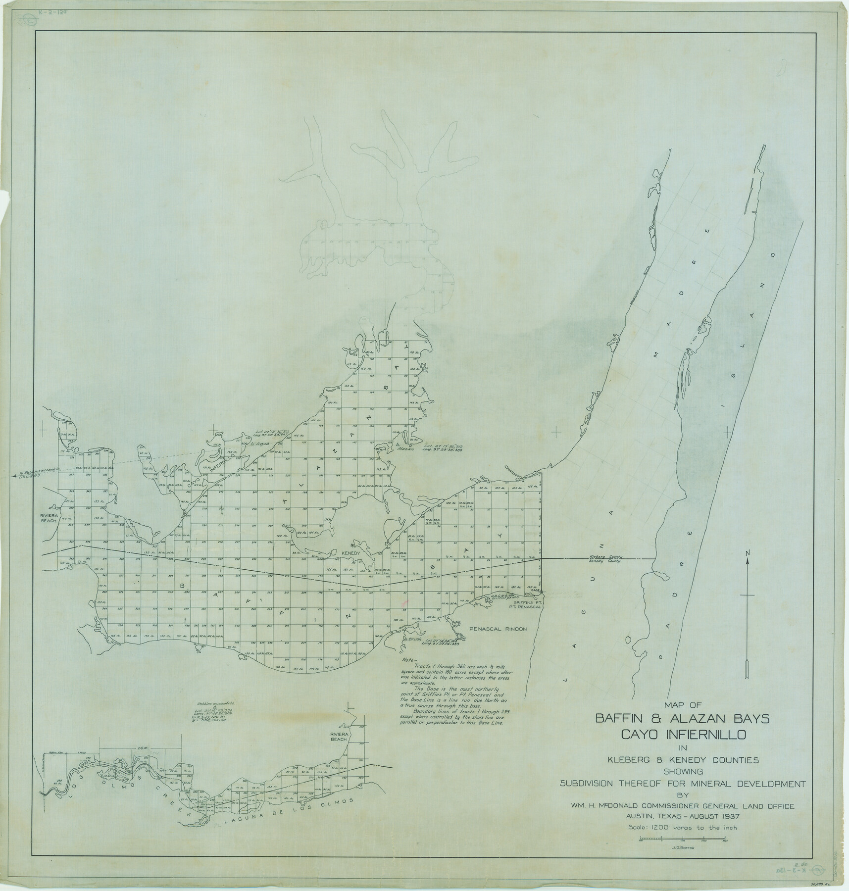
Map of Baffin & Alazan Bays, Cayo Infiernillo in Kenedy & Kleberg Counties Showing Subdivision for Mineral Development
K-3-13
-
Map/Doc
3016
-
Collection
General Map Collection
-
Object Dates
1937 (Creation Date)
-
People and Organizations
General Land Office (Publisher)
-
Counties
Kleberg Kenedy
-
Subjects
Energy Offshore Submerged Area
-
Height x Width
42.4 x 40.4 inches
107.7 x 102.6 cm
Part of: General Map Collection
Val Verde County Working Sketch 75

Print $40.00
- Digital $50.00
Val Verde County Working Sketch 75
1971
Size 31.4 x 49.2 inches
Map/Doc 72210
Victoria County Sketch File 4

Print $7.00
- Digital $50.00
Victoria County Sketch File 4
1876
Size 10.1 x 8.2 inches
Map/Doc 39517
Bandera County Working Sketch 6

Print $20.00
- Digital $50.00
Bandera County Working Sketch 6
1917
Size 14.2 x 14.3 inches
Map/Doc 67599
Flight Mission No. CGI-1N, Frame 213, Cameron County

Print $20.00
- Digital $50.00
Flight Mission No. CGI-1N, Frame 213, Cameron County
1955
Size 18.5 x 22.2 inches
Map/Doc 84522
Victoria County Rolled Sketch 4B

Print $40.00
- Digital $50.00
Victoria County Rolled Sketch 4B
1963
Size 65.3 x 43.3 inches
Map/Doc 10096
Flight Mission No. CRC-2R, Frame 136, Chambers County

Print $20.00
- Digital $50.00
Flight Mission No. CRC-2R, Frame 136, Chambers County
1956
Size 18.7 x 22.4 inches
Map/Doc 84752
Presidio County Sketch File 75

Print $30.00
- Digital $50.00
Presidio County Sketch File 75
1946
Size 8.9 x 14.3 inches
Map/Doc 34691
La Salle County Working Sketch 12

Print $20.00
- Digital $50.00
La Salle County Working Sketch 12
1929
Size 25.4 x 15.8 inches
Map/Doc 70313
Hays County Sketch File 22

Print $4.00
- Digital $50.00
Hays County Sketch File 22
Size 8.4 x 7.3 inches
Map/Doc 26249
Dimmit County

Print $40.00
- Digital $50.00
Dimmit County
1976
Size 43.2 x 50.7 inches
Map/Doc 73133
Loving County Sketch File 7

Print $2.00
- Digital $50.00
Loving County Sketch File 7
1977
Size 12.1 x 8.8 inches
Map/Doc 30417
Cherokee County Working Sketch 1

Print $20.00
- Digital $50.00
Cherokee County Working Sketch 1
1925
Size 22.9 x 24.1 inches
Map/Doc 67956
You may also like
University Lands as resurveyed by Frank F. Friend, Special Surveyor, San Angelo, Texas projected on a map of the State of Texas

Print $40.00
- Digital $50.00
University Lands as resurveyed by Frank F. Friend, Special Surveyor, San Angelo, Texas projected on a map of the State of Texas
1936
Size 31.0 x 55.8 inches
Map/Doc 2418
Montgomery County Rolled Sketch 27

Print $20.00
- Digital $50.00
Montgomery County Rolled Sketch 27
Size 34.5 x 34.4 inches
Map/Doc 9536
Leon County Working Sketch 37

Print $20.00
- Digital $50.00
Leon County Working Sketch 37
1979
Size 43.2 x 37.7 inches
Map/Doc 70436
Motley County Boundary File 2d

Print $22.00
- Digital $50.00
Motley County Boundary File 2d
Size 14.3 x 8.7 inches
Map/Doc 57550
Mme. Begue and her Recipes - Old Creole Cookery

Mme. Begue and her Recipes - Old Creole Cookery
1900
Size 5.9 x 3.9 inches
Map/Doc 96607
Upton County Sketch File 12

Print $20.00
- Digital $50.00
Upton County Sketch File 12
1926
Size 20.6 x 34.8 inches
Map/Doc 12512
Brazoria County Sketch File 55

Print $80.00
- Digital $50.00
Brazoria County Sketch File 55
1899
Size 14.9 x 55.0 inches
Map/Doc 10327
Map of Burnet Co.

Print $20.00
- Digital $50.00
Map of Burnet Co.
1887
Size 45.5 x 37.9 inches
Map/Doc 7816
Ward County Sketch File 10

Print $6.00
- Digital $50.00
Ward County Sketch File 10
1936
Size 11.2 x 8.9 inches
Map/Doc 39635

Map of Maryland, Virginia, North Carolina and South Carolina

Print $20.00
- Digital $50.00
Map of Maryland, Virginia, North Carolina and South Carolina
1885
Size 12.2 x 9.0 inches
Map/Doc 93517
The M. K. and T., Missouri, Kansas & Texas Railway

Print $20.00
- Digital $50.00
The M. K. and T., Missouri, Kansas & Texas Railway
1890
Size 25.0 x 27.9 inches
Map/Doc 95807