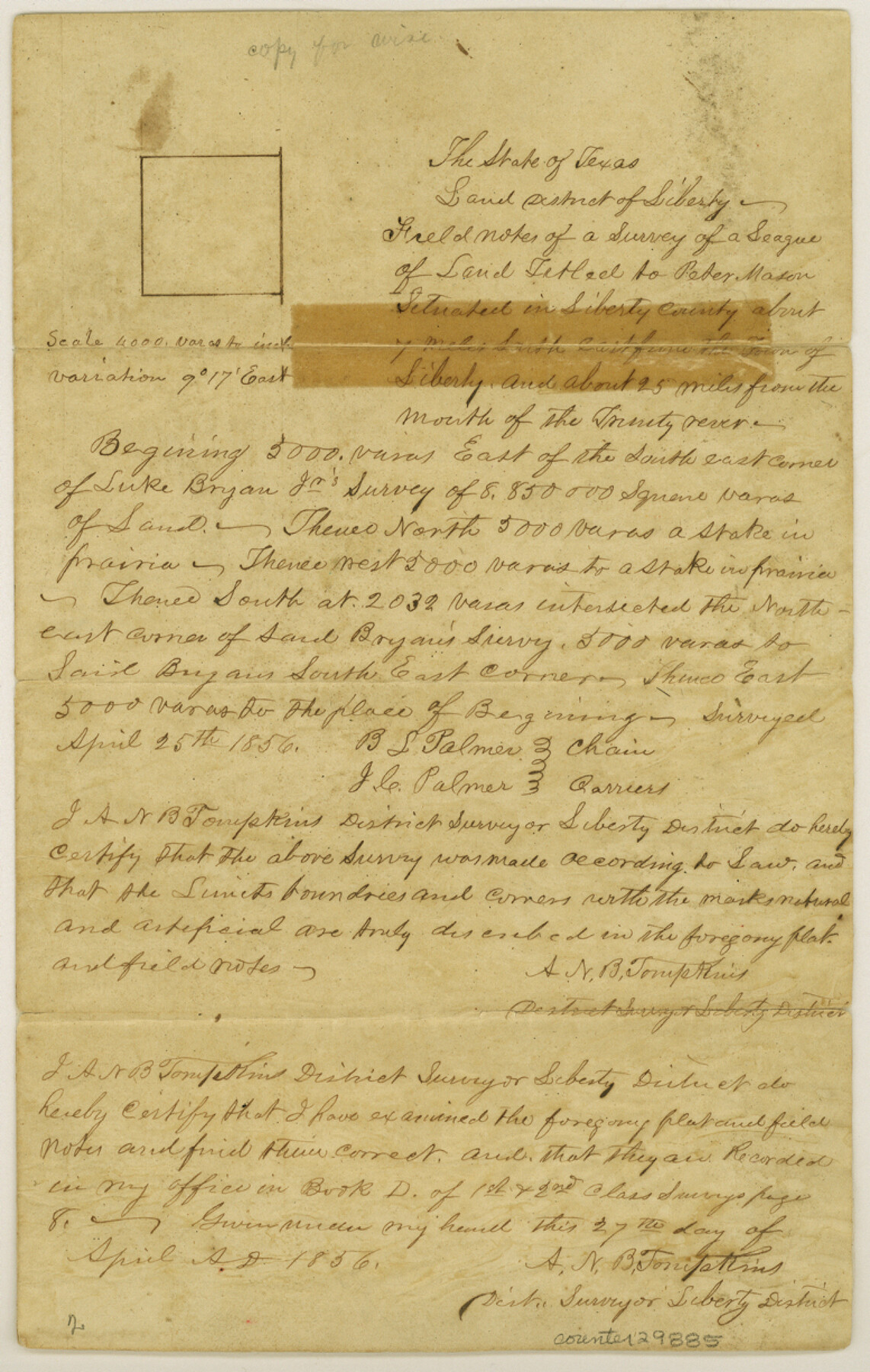
Liberty County Sketch File 4
[Field notes of a survey of a League of land titled to Peter Mason]
- 
                          Map/Doc
29885
 - 
                            Collection
General Map Collection
 - 
                            Object Dates
4/27/1856 (Creation Date)
5/12/1856 (File Date)
4/25/1856 (Survey Date)
 - 
                            People and Organizations
B.L. Palmer (Chainman/Field Personnel)
J.C. Palmer (Chainman/Field Personnel)
A.N.B. Tompkins (Surveyor/Engineer)
 - 
                            Counties
Liberty
 - 
                            Subjects
Surveying Sketch File
 - 
                            Height x Width
12.2 x 7.8 inches
31.0 x 19.8 cm
 - 
                            Medium
paper, manuscript
 - 
                            Scale
1" = 4000 varas
 - 
                            Features
Trinity River
 
Part of: General Map Collection
            Intracoastal Waterway in Texas - Corpus Christi to Point Isabel including Arroyo Colorado to Mo. Pac. R.R. Bridge Near Harlingen


                                            Print $20.00                    
                                             -                         Digital $50.00                                    
                Intracoastal Waterway in Texas - Corpus Christi to Point Isabel including Arroyo Colorado to Mo. Pac. R.R. Bridge Near Harlingen
1934
Size 22.0 x 32.7 inches
                                Map/Doc 61884
            
            Maps of Gulf Intracoastal Waterway, Texas - Sabine River to the Rio Grande and connecting waterways including ship channels


                                            Print $20.00                    
                                             -                         Digital $50.00                                    
                Maps of Gulf Intracoastal Waterway, Texas - Sabine River to the Rio Grande and connecting waterways including ship channels
1966
Size 14.6 x 22.2 inches
                                Map/Doc 61971
            
            Brewster County Working Sketch 96


                                            Print $20.00                    
                                             -                         Digital $50.00                                    
                Brewster County Working Sketch 96
1976
Size 29.4 x 20.3 inches
                                Map/Doc 67696
            
            Zavala County Boundary File 3


                                            Print $44.00                    
                                             -                         Digital $50.00                                    
                Zavala County Boundary File 3
Size 9.4 x 7.3 inches
                                Map/Doc 60258
            
            Pecos County Working Sketch 23


                                            Print $20.00                    
                                             -                         Digital $50.00                                    
                Pecos County Working Sketch 23
1927
Size 45.6 x 40.6 inches
                                Map/Doc 71494
            
            Hudspeth County Working Sketch 13


                                            Print $40.00                    
                                             -                         Digital $50.00                                    
                Hudspeth County Working Sketch 13
1952
Size 34.3 x 51.4 inches
                                Map/Doc 66295
            
            Menard County Sketch File 24


                                            Print $20.00                    
                                             -                         Digital $50.00                                    
                Menard County Sketch File 24
1932
Size 17.0 x 26.5 inches
                                Map/Doc 12077
            
            Calhoun County Rolled Sketch 9


                                            Print $20.00                    
                                             -                         Digital $50.00                                    
                Calhoun County Rolled Sketch 9
Size 24.4 x 38.7 inches
                                Map/Doc 5365
            
            Kent County Boundary File 4a


                                            Print $18.00                    
                                             -                         Digital $50.00                                    
                Kent County Boundary File 4a
Size 14.2 x 8.5 inches
                                Map/Doc 55838
            
            Ward County Working Sketch 53


                                            Print $40.00                    
                                             -                         Digital $50.00                                    
                Ward County Working Sketch 53
1982
Size 37.0 x 53.4 inches
                                Map/Doc 72359
            
            Kent County Working Sketch 23


                                            Print $20.00                    
                                             -                         Digital $50.00                                    
                Kent County Working Sketch 23
1987
Size 47.2 x 43.0 inches
                                Map/Doc 70030
            
            Grayson County Working Sketch 11


                                            Print $20.00                    
                                             -                         Digital $50.00                                    
                Grayson County Working Sketch 11
1951
Size 27.9 x 24.3 inches
                                Map/Doc 63250
            You may also like
            [W. E. Halsell's Subdivision of Capitol Leagues, Blocks T1,T2, T3, and S2]


                                            Print $20.00                    
                                             -                         Digital $50.00                                    
                [W. E. Halsell's Subdivision of Capitol Leagues, Blocks T1,T2, T3, and S2]
1907
Size 20.5 x 16.5 inches
                                Map/Doc 92164
            
            The Republic County of Lamar. January 28, 1841


                                            Print $20.00                    
                                    
                The Republic County of Lamar. January 28, 1841
2020
Size 16.4 x 21.7 inches
                                Map/Doc 96203
            
            Liberty County Sketch File 26


                                            Print $10.00                    
                                             -                         Digital $50.00                                    
                Liberty County Sketch File 26
1859
Size 8.3 x 9.2 inches
                                Map/Doc 29943
            
            Upton County Rolled Sketch 28


                                            Print $20.00                    
                                             -                         Digital $50.00                                    
                Upton County Rolled Sketch 28
Size 19.6 x 27.5 inches
                                Map/Doc 8075
            
            Travis County Rolled Sketch 58


                                            Print $20.00                    
                                             -                         Digital $50.00                                    
                Travis County Rolled Sketch 58
Size 37.4 x 25.5 inches
                                Map/Doc 8049
            
            Zavala County Sketch File 18


                                            Print $16.00                    
                                             -                         Digital $50.00                                    
                Zavala County Sketch File 18
1897
Size 14.0 x 9.1 inches
                                Map/Doc 41356
            
            Hispaniae Novae Sivae Magnae Recens et Vera Descriptio 1579


                                            Print $20.00                    
                                             -                         Digital $50.00                                    
                Hispaniae Novae Sivae Magnae Recens et Vera Descriptio 1579
1581
Size 17.9 x 23.0 inches
                                Map/Doc 94036
            
            Limestone County Working Sketch 22


                                            Print $40.00                    
                                             -                         Digital $50.00                                    
                Limestone County Working Sketch 22
1980
Size 43.3 x 60.2 inches
                                Map/Doc 70572
            
            Reeves County Rolled Sketch N1


                                            Print $20.00                    
                                             -                         Digital $50.00                                    
                Reeves County Rolled Sketch N1
Size 21.8 x 41.9 inches
                                Map/Doc 7505
            
            Donley County Working Sketch 2


                                            Print $20.00                    
                                             -                         Digital $50.00                                    
                Donley County Working Sketch 2
1916
Size 15.2 x 17.1 inches
                                Map/Doc 68735
            
            Mitchell County Boundary File 66a


                                            Print $11.00                    
                                             -                         Digital $50.00                                    
                Mitchell County Boundary File 66a
Size 12.6 x 8.3 inches
                                Map/Doc 57378