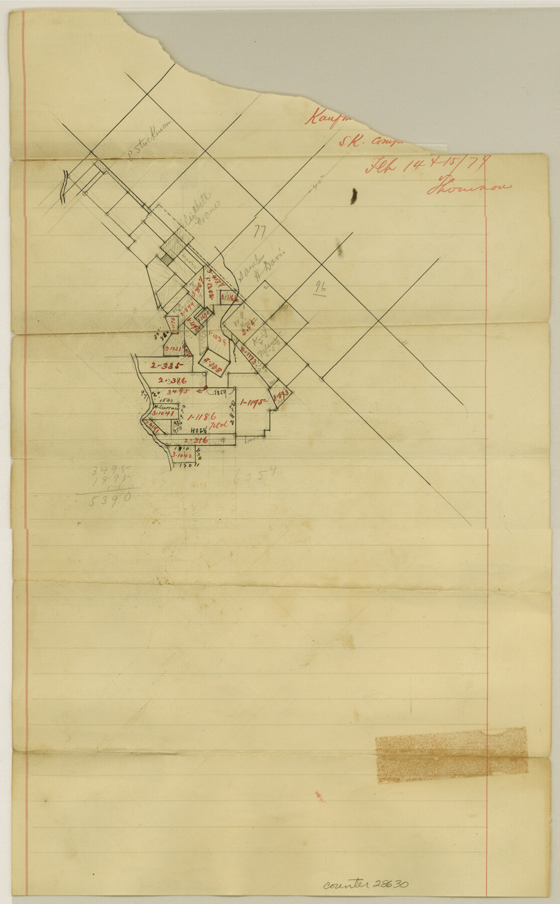
Kaufman County Sketch File A
[Surveys between the Samuel A. Davis tract no. 77 and the east bank of the Trinity River]
-
Map/Doc
28630
-
Collection
General Map Collection
-
Object Dates
2/15/1879 (Creation Date)
-
Counties
Kaufman Dallas
-
Subjects
Surveying Sketch File
-
Height x Width
14.1 x 8.8 inches
35.8 x 22.4 cm
-
Medium
paper, manuscript
Part of: General Map Collection
Tom Green County Sketch File 66

Print $22.00
- Digital $50.00
Tom Green County Sketch File 66
1929
Size 16.8 x 14.6 inches
Map/Doc 38236
North Part Brewster Co.

Print $40.00
- Digital $50.00
North Part Brewster Co.
1914
Size 40.1 x 48.6 inches
Map/Doc 66731
Real County Working Sketch 73

Print $20.00
- Digital $50.00
Real County Working Sketch 73
1978
Size 28.2 x 24.9 inches
Map/Doc 71965
Birds-eye view of the camp of the army of occupation commanded by Genl. Taylor near Corpus Christi, Texas (from the North)

Print $20.00
- Digital $50.00
Birds-eye view of the camp of the army of occupation commanded by Genl. Taylor near Corpus Christi, Texas (from the North)
1847
Size 15.8 x 20.5 inches
Map/Doc 95951
Midland County Rolled Sketch 4

Print $40.00
- Digital $50.00
Midland County Rolled Sketch 4
Size 43.5 x 85.6 inches
Map/Doc 10696
Shackelford County Sketch File 7

Print $20.00
- Digital $50.00
Shackelford County Sketch File 7
1912
Size 27.2 x 13.5 inches
Map/Doc 12314
Dawson County Working Sketch Graphic Index

Print $20.00
- Digital $50.00
Dawson County Working Sketch Graphic Index
1959
Size 40.7 x 33.4 inches
Map/Doc 76518
Bandera County Working Sketch 16d

Print $20.00
- Digital $50.00
Bandera County Working Sketch 16d
1941
Size 19.1 x 23.2 inches
Map/Doc 67612
Shelby County Rolled Sketch 18

Print $20.00
- Digital $50.00
Shelby County Rolled Sketch 18
1975
Size 36.2 x 40.7 inches
Map/Doc 9926
Ellis County Boundary File 5

Print $4.00
- Digital $50.00
Ellis County Boundary File 5
Size 11.5 x 7.2 inches
Map/Doc 52990
Hardeman County Working Sketch 14

Print $20.00
- Digital $50.00
Hardeman County Working Sketch 14
Size 30.8 x 42.2 inches
Map/Doc 63395
Cameron County Rolled Sketch 8

Print $40.00
- Digital $50.00
Cameron County Rolled Sketch 8
1937
Size 42.5 x 54.1 inches
Map/Doc 8565
You may also like
Zavala County Sketch File 44

Print $25.00
- Digital $50.00
Zavala County Sketch File 44
1915
Size 10.1 x 14.3 inches
Map/Doc 41416
Hays County Sketch File 19a

Print $39.00
- Digital $50.00
Hays County Sketch File 19a
1894
Size 19.4 x 28.6 inches
Map/Doc 11749
Map of Jones County

Print $20.00
- Digital $50.00
Map of Jones County
1898
Size 41.2 x 40.0 inches
Map/Doc 16862
Hardin County Sketch File 27

Print $4.00
- Digital $50.00
Hardin County Sketch File 27
Size 13.0 x 8.1 inches
Map/Doc 25151
Dickens County Working Sketch Graphic Index

Print $20.00
- Digital $50.00
Dickens County Working Sketch Graphic Index
1963
Size 42.5 x 33.6 inches
Map/Doc 76523
Culberson County Rolled Sketch 34

Print $20.00
- Digital $50.00
Culberson County Rolled Sketch 34
1938
Size 43.5 x 43.6 inches
Map/Doc 8749
A plat representing the survey and resubdivision of four tracts of land known as tracts no. 27, no. 26, no. 23, and no. 22, all of which are part of the Tara Subdivision, an unrecorded subdivision of 263.28 acres out of the J. M. Speer Subdivision

Print $6.00
- Digital $50.00
A plat representing the survey and resubdivision of four tracts of land known as tracts no. 27, no. 26, no. 23, and no. 22, all of which are part of the Tara Subdivision, an unrecorded subdivision of 263.28 acres out of the J. M. Speer Subdivision
1991
Size 24.7 x 34.3 inches
Map/Doc 3112
Kimble County Working Sketch 54

Print $20.00
- Digital $50.00
Kimble County Working Sketch 54
1954
Size 32.3 x 23.1 inches
Map/Doc 70122
[G. C. & S. F. Ry. Co. Block H, E. L. & R. R. Ry. Co. Block D7 and vicinity]
![91864, [G. C. & S. F. Ry. Co. Block H, E. L. & R. R. Ry. Co. Block D7 and vicinity], Twichell Survey Records](https://historictexasmaps.com/wmedia_w700/maps/91864-1.tif.jpg)
Print $20.00
- Digital $50.00
[G. C. & S. F. Ry. Co. Block H, E. L. & R. R. Ry. Co. Block D7 and vicinity]
Size 15.0 x 18.5 inches
Map/Doc 91864
Erath County Sketch File 2

Print $20.00
- Digital $50.00
Erath County Sketch File 2
Size 13.2 x 15.5 inches
Map/Doc 11463
Shelby County Sketch File 9

Print $4.00
- Digital $50.00
Shelby County Sketch File 9
1858
Size 9.4 x 8.2 inches
Map/Doc 36609
Bexar County Boundary File 2a

Print $12.00
- Digital $50.00
Bexar County Boundary File 2a
Size 10.0 x 8.1 inches
Map/Doc 50530