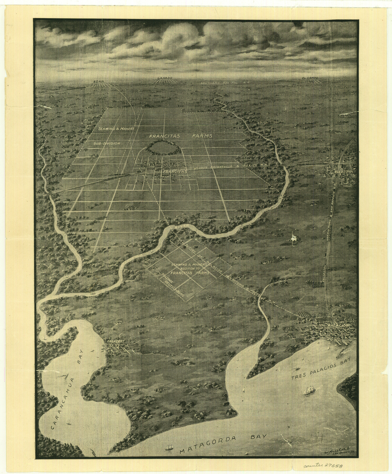
Jackson County Sketch File 12a
[Bird's-eye view of southern part of Jackson County]
-
Map/Doc
27658
-
Collection
General Map Collection
-
Object Dates
1913/2/26 (File Date)
-
People and Organizations
The Mills Eng. Co. (Printer)
-
Counties
Jackson
-
Subjects
Surveying Sketch File
-
Height x Width
17.4 x 14.4 inches
44.2 x 36.6 cm
-
Medium
paper, etching/engraving/lithograph
-
Features
Edna
Ganado
Southern Pacific Railroad
El Campo
Franictas Farms
Schwind & Maher's Subdivision
Blessing
GH&SA
Palacios & San Antonio Railroad
Kolonie Deutschburg Subdivision
Freeport
Carancahua Bay
Tres Palacios Bay
Palacios
Matagorda Bay
Carancahua River
Part of: General Map Collection
Galveston County Rolled Sketch 27A

Print $20.00
- Digital $50.00
Galveston County Rolled Sketch 27A
1978
Size 32.2 x 35.5 inches
Map/Doc 5962
Red River County Working Sketch 84

Print $20.00
- Digital $50.00
Red River County Working Sketch 84
1989
Size 24.9 x 40.3 inches
Map/Doc 72070
Burleson County Working Sketch 18

Print $20.00
- Digital $50.00
Burleson County Working Sketch 18
1980
Size 17.6 x 7.8 inches
Map/Doc 67737
Val Verde County Rolled Sketch 22

Print $40.00
- Digital $50.00
Val Verde County Rolled Sketch 22
1892
Size 51.8 x 38.7 inches
Map/Doc 10071
Flight Mission No. DQO-3K, Frame 24, Galveston County

Print $20.00
- Digital $50.00
Flight Mission No. DQO-3K, Frame 24, Galveston County
1952
Size 18.7 x 22.4 inches
Map/Doc 85065
Right of Way and Track Map - Houston & Texas Central R.R. operated by the T. and N. O. R.R. Co. - Main Line

Print $40.00
- Digital $50.00
Right of Way and Track Map - Houston & Texas Central R.R. operated by the T. and N. O. R.R. Co. - Main Line
1918
Size 25.2 x 57.8 inches
Map/Doc 82859
Menard County Boundary File 5

Print $8.00
- Digital $50.00
Menard County Boundary File 5
Size 12.7 x 8.1 inches
Map/Doc 57082
Potter County Sketch File 6

Print $20.00
- Digital $50.00
Potter County Sketch File 6
1900
Size 34.4 x 29.0 inches
Map/Doc 10575
Galveston County Sketch File 2a

Print $4.00
- Digital $50.00
Galveston County Sketch File 2a
1848
Size 14.3 x 8.8 inches
Map/Doc 23350
[Map of the River Sabine from its mouth on the Gulf of Mexico in the sea to Logan's Ferry in Latitude 31° 58' 24" North]
![94005, [Map of the River Sabine from its mouth on the Gulf of Mexico in the sea to Logan's Ferry in Latitude 31° 58' 24" North], General Map Collection](https://historictexasmaps.com/wmedia_w700/maps/94005.tif.jpg)
Print $20.00
- Digital $50.00
[Map of the River Sabine from its mouth on the Gulf of Mexico in the sea to Logan's Ferry in Latitude 31° 58' 24" North]
Size 31.5 x 31.3 inches
Map/Doc 94005
Palo Pinto County Working Sketch 20

Print $20.00
- Digital $50.00
Palo Pinto County Working Sketch 20
1977
Size 30.2 x 38.1 inches
Map/Doc 71403
Bexar County Rolled Sketch 5

Print $20.00
- Digital $50.00
Bexar County Rolled Sketch 5
1984
Size 24.3 x 18.6 inches
Map/Doc 5140
You may also like
Flight Mission No. DQN-1K, Frame 133, Calhoun County

Print $20.00
- Digital $50.00
Flight Mission No. DQN-1K, Frame 133, Calhoun County
1953
Size 18.6 x 22.4 inches
Map/Doc 84196
Brazoria County Sketch File 57

Print $10.00
- Digital $50.00
Brazoria County Sketch File 57
1940
Size 8.7 x 6.3 inches
Map/Doc 15377
Stephens County Working Sketch 22

Print $40.00
- Digital $50.00
Stephens County Working Sketch 22
1975
Size 32.9 x 49.0 inches
Map/Doc 63965
Map showing lands of D. Sullivan situated in Starr County, Texas

Print $20.00
- Digital $50.00
Map showing lands of D. Sullivan situated in Starr County, Texas
Size 15.5 x 18.6 inches
Map/Doc 755
San Augustine County Sketch File 21

Print $4.00
- Digital $50.00
San Augustine County Sketch File 21
1873
Size 12.8 x 7.9 inches
Map/Doc 35685
Navarro County, 1888

Print $20.00
- Digital $50.00
Navarro County, 1888
1888
Size 43.8 x 32.2 inches
Map/Doc 89651


Flight Mission No. BQR-13K, Frame 164, Brazoria County

Print $20.00
- Digital $50.00
Flight Mission No. BQR-13K, Frame 164, Brazoria County
1952
Size 18.8 x 22.4 inches
Map/Doc 84089
[Sketch of Blks. C-11, C-10, C-8, C-9, C-17 and other in vicinity]
![89793, [Sketch of Blks. C-11, C-10, C-8, C-9, C-17 and other in vicinity], Twichell Survey Records](https://historictexasmaps.com/wmedia_w700/maps/89793-1.tif.jpg)
Print $20.00
- Digital $50.00
[Sketch of Blks. C-11, C-10, C-8, C-9, C-17 and other in vicinity]
Size 43.8 x 39.2 inches
Map/Doc 89793
Clay County Sketch File 4

Print $22.00
- Digital $50.00
Clay County Sketch File 4
1854
Size 5.0 x 7.5 inches
Map/Doc 18392
Angelina County Sketch File 4

Print $4.00
- Digital $50.00
Angelina County Sketch File 4
1854
Size 8.3 x 9.0 inches
Map/Doc 12926