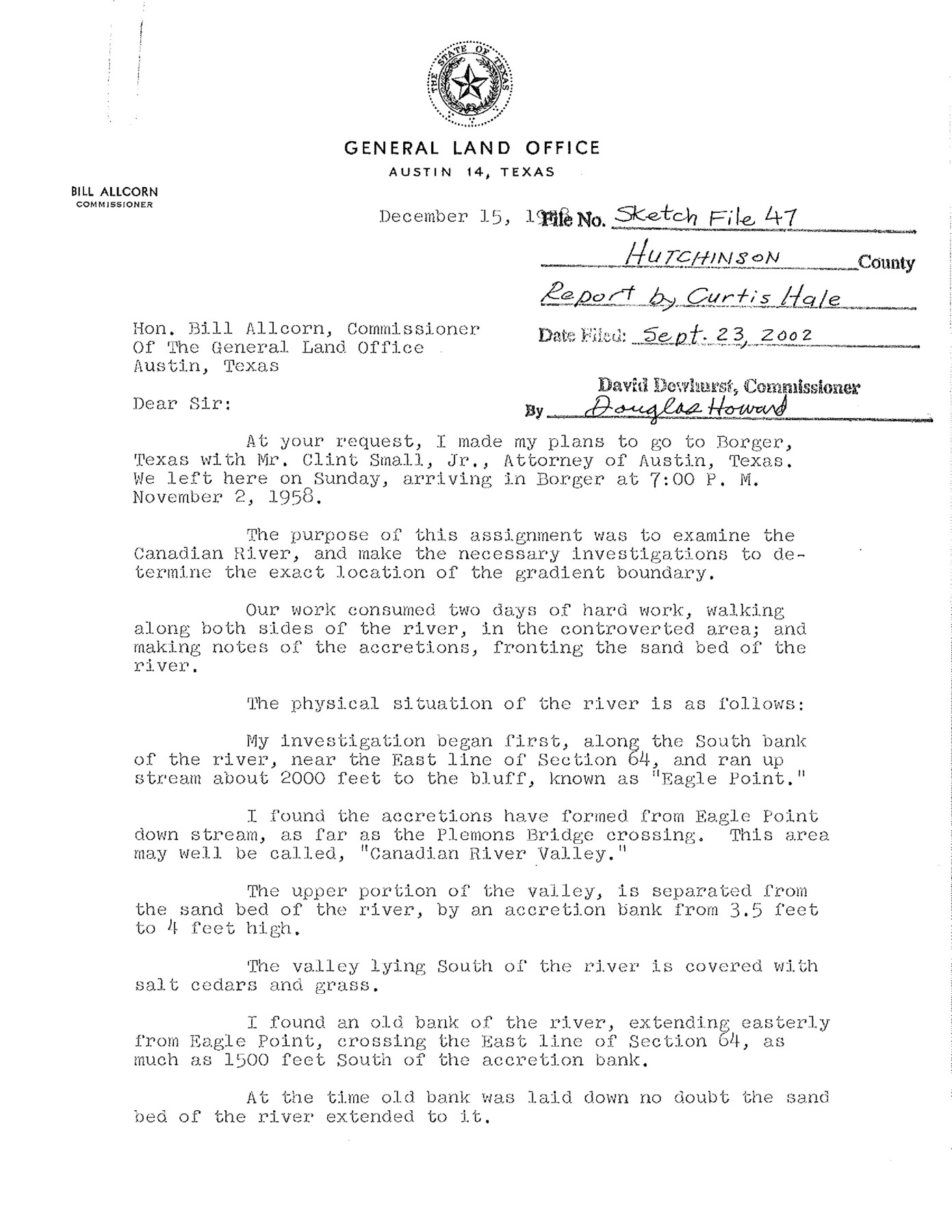
Hutchinson County Sketch File 47
[Report and photographs of the Canadian River regarding the exact location of the gradient boundary]
-
Map/Doc
27390
-
Collection
General Map Collection
-
Object Dates
1958 (Creation Date)
8/6/1993 (File Date)
9/23/2002 (File Date)
-
People and Organizations
Curtis Hale (Surveyor/Engineer)
-
Counties
Hutchinson
-
Subjects
Surveying Sketch File
-
Height x Width
8.3 x 10.1 inches
21.1 x 25.7 cm
-
Medium
photograph
-
Features
Patton Creek
Eagle Point
Stinnett Bridge
Part of: General Map Collection
Flight Mission No. CGI-3N, Frame 186, Cameron County

Print $20.00
- Digital $50.00
Flight Mission No. CGI-3N, Frame 186, Cameron County
1954
Size 18.6 x 22.3 inches
Map/Doc 84650
Sketch Showing Surveys Made for W. R. Cartledge

Print $20.00
- Digital $50.00
Sketch Showing Surveys Made for W. R. Cartledge
1945
Size 16.9 x 14.4 inches
Map/Doc 2059
Lampasas County Rolled Sketch 2

Print $20.00
- Digital $50.00
Lampasas County Rolled Sketch 2
Size 21.0 x 39.2 inches
Map/Doc 6565
Right of Way and Track Map of The Wichita Falls & Southern Railroad Company

Print $40.00
- Digital $50.00
Right of Way and Track Map of The Wichita Falls & Southern Railroad Company
1942
Size 24.7 x 56.3 inches
Map/Doc 64521
Duval County Rolled Sketch 30

Print $20.00
- Digital $50.00
Duval County Rolled Sketch 30
1947
Size 15.8 x 27.8 inches
Map/Doc 5747
Matagorda County NRC Article 33.136 Sketch 6

Print $42.00
- Digital $50.00
Matagorda County NRC Article 33.136 Sketch 6
2010
Size 22.0 x 34.0 inches
Map/Doc 94646
Hutchinson County Rolled Sketch 4

Print $20.00
- Digital $50.00
Hutchinson County Rolled Sketch 4
Size 21.3 x 30.1 inches
Map/Doc 6277
Shelby County Sketch File 32

Print $20.00
- Digital $50.00
Shelby County Sketch File 32
1949
Size 23.4 x 17.7 inches
Map/Doc 12321
Map of West Part of Pecos Co.

Print $20.00
- Digital $50.00
Map of West Part of Pecos Co.
1896
Size 47.4 x 39.3 inches
Map/Doc 66974
Flight Mission No. DIX-7P, Frame 18, Aransas County

Print $20.00
- Digital $50.00
Flight Mission No. DIX-7P, Frame 18, Aransas County
1956
Size 19.0 x 22.6 inches
Map/Doc 83870
Fractional Township No. 8 South Range No. 5 East of the Indian Meridian, Indian Territory

Print $20.00
- Digital $50.00
Fractional Township No. 8 South Range No. 5 East of the Indian Meridian, Indian Territory
1898
Size 19.2 x 24.4 inches
Map/Doc 75209
Frio County Working Sketch 11

Print $20.00
- Digital $50.00
Frio County Working Sketch 11
1952
Size 22.9 x 20.0 inches
Map/Doc 69285
You may also like
McLennan County Sketch File 3

Print $4.00
- Digital $50.00
McLennan County Sketch File 3
1857
Size 11.1 x 8.1 inches
Map/Doc 31233
Cooke County Sketch File 15

Print $4.00
- Digital $50.00
Cooke County Sketch File 15
1860
Size 12.5 x 8.1 inches
Map/Doc 19250
Map representing the surveys made in Bexar County

Print $40.00
- Digital $50.00
Map representing the surveys made in Bexar County
1839
Size 75.7 x 37.9 inches
Map/Doc 93364
Highway Addition to Littlefield, Texas

Print $3.00
- Digital $50.00
Highway Addition to Littlefield, Texas
Size 14.3 x 11.7 inches
Map/Doc 92266
Jackson County Working Sketch 8

Print $20.00
- Digital $50.00
Jackson County Working Sketch 8
1980
Size 30.4 x 29.0 inches
Map/Doc 66456
Polk County Sketch File 19

Print $4.00
- Digital $50.00
Polk County Sketch File 19
1863
Size 8.2 x 12.7 inches
Map/Doc 34165
Old Miscellaneous File 6

Print $4.00
- Digital $50.00
Old Miscellaneous File 6
1847
Size 4.2 x 7.6 inches
Map/Doc 75420
Flight Mission No. BRE-1P, Frame 56, Nueces County

Print $20.00
- Digital $50.00
Flight Mission No. BRE-1P, Frame 56, Nueces County
1956
Size 18.5 x 22.4 inches
Map/Doc 86645
Colorado County Sketch File 21

Print $8.00
- Digital $50.00
Colorado County Sketch File 21
Size 13.1 x 8.8 inches
Map/Doc 18957
Map of the Texas & Pacific Ry. Reserve West of the Pecos River

Print $20.00
- Digital $50.00
Map of the Texas & Pacific Ry. Reserve West of the Pecos River
1879
Size 41.1 x 29.8 inches
Map/Doc 65332
Current Miscellaneous File 94

Print $3.00
- Digital $50.00
Current Miscellaneous File 94
1851
Size 11.2 x 17.1 inches
Map/Doc 74268
Floyd County Sketch File 13

Print $36.00
- Digital $50.00
Floyd County Sketch File 13
1913
Size 11.4 x 9.0 inches
Map/Doc 22713