Hansford County Sketch File 8
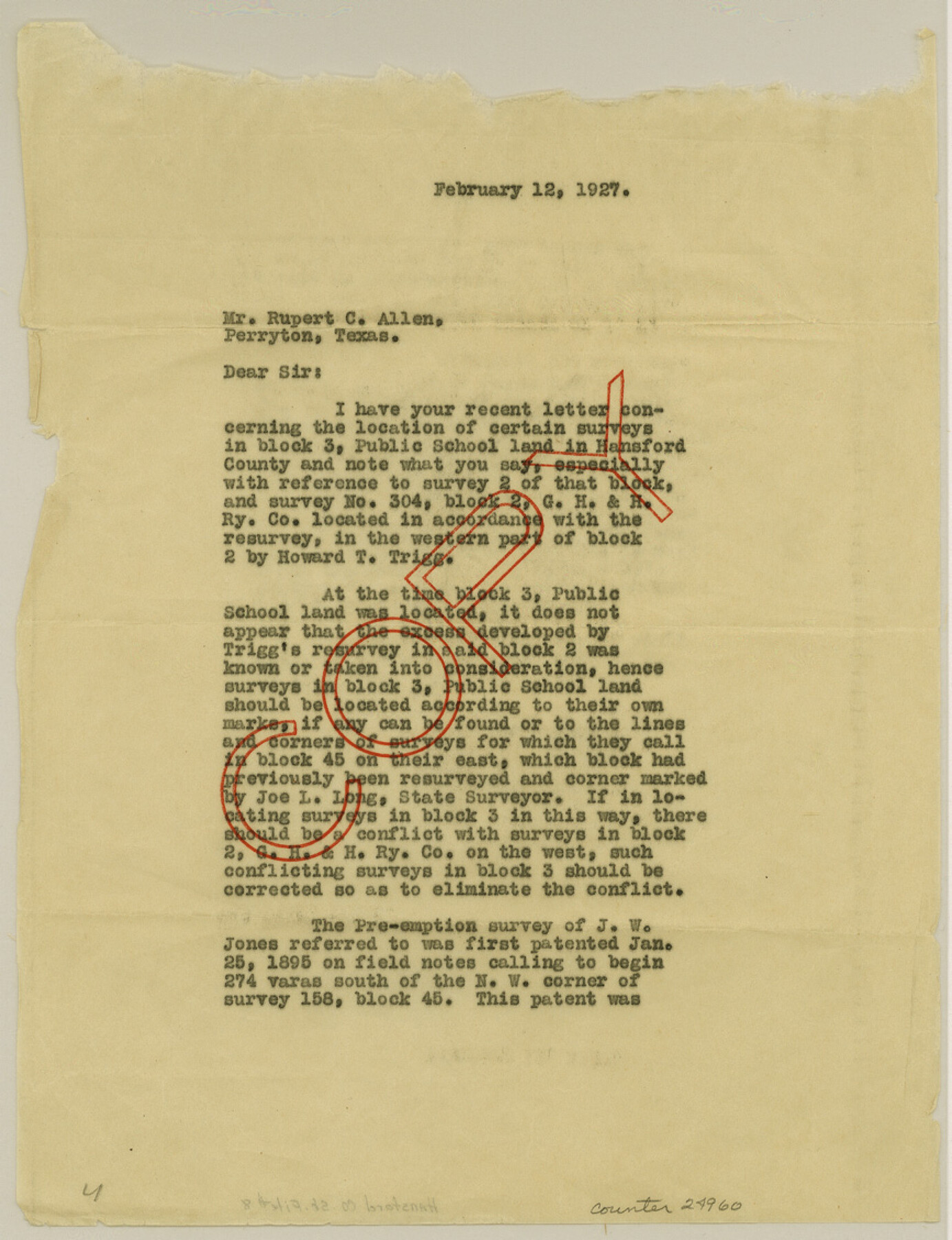
[Letter of instruction to Rupert C. Allen as to proper way of correcting surveys]
-
Map/Doc
24960
-
Collection
General Map Collection
-
Object Dates
1927/2/12 (Creation Date)
1922/2/2 (Survey Date)
1917/12/10 (Survey Date)
-
People and Organizations
Blucher (Surveyor/Engineer)
Howard T. Trigg (Surveyor/Engineer)
Joe L. Long (Surveyor/Engineer)
-
Counties
Hansford
-
Subjects
Surveying Sketch File
-
Height x Width
11.3 x 8.7 inches
28.7 x 22.1 cm
-
Medium
paper, print
Part of: General Map Collection
Map of San Antonio, Texas, Postal Delivery Units showing all boundary lines / Tourist Map of San Antonio showing points of interest and places of amusements, main thoroughfares and highways in and out of city and where they go / Business Section Map

Map of San Antonio, Texas, Postal Delivery Units showing all boundary lines / Tourist Map of San Antonio showing points of interest and places of amusements, main thoroughfares and highways in and out of city and where they go / Business Section Map
Size 18.0 x 24.0 inches
Map/Doc 95160
Atascosa County Working Sketch 32

Print $20.00
- Digital $50.00
Atascosa County Working Sketch 32
1981
Size 12.9 x 11.8 inches
Map/Doc 67228
Kimble County Working Sketch 68

Print $20.00
- Digital $50.00
Kimble County Working Sketch 68
1965
Size 23.1 x 31.5 inches
Map/Doc 70136
San Luis Pass to East Matagorda Bay

Print $20.00
- Digital $50.00
San Luis Pass to East Matagorda Bay
1972
Size 34.7 x 47.2 inches
Map/Doc 69967
Jefferson County Working Sketch 4

Print $20.00
- Digital $50.00
Jefferson County Working Sketch 4
1930
Size 19.4 x 28.0 inches
Map/Doc 66547
Wise County Working Sketch 22

Print $20.00
- Digital $50.00
Wise County Working Sketch 22
1980
Size 28.1 x 27.8 inches
Map/Doc 72636
Lubbock County Sketch File 11

Print $20.00
- Digital $50.00
Lubbock County Sketch File 11
1914
Size 19.4 x 18.5 inches
Map/Doc 4585
Map of Webb Co.

Print $20.00
- Digital $50.00
Map of Webb Co.
1901
Size 40.4 x 47.1 inches
Map/Doc 16919
Flight Mission No. DAG-17K, Frame 78, Matagorda County

Print $20.00
- Digital $50.00
Flight Mission No. DAG-17K, Frame 78, Matagorda County
1952
Size 18.7 x 22.4 inches
Map/Doc 86337
Karnes County Sketch File 16

Print $20.00
- Digital $50.00
Karnes County Sketch File 16
1950
Size 14.4 x 30.7 inches
Map/Doc 11905
Township No. 5 South, Range No. 13 West, Indian Meridian, Oklahoma

Print $4.00
- Digital $50.00
Township No. 5 South, Range No. 13 West, Indian Meridian, Oklahoma
1928
Size 17.9 x 23.0 inches
Map/Doc 75142
Hardeman County Working Sketch 2

Print $20.00
- Digital $50.00
Hardeman County Working Sketch 2
1900
Size 19.1 x 19.4 inches
Map/Doc 63383
You may also like
Treaty to Resolve Pending Boundary Differences and Maintain the Rio Grande and Colorado River as the International Boundary Between the United States of American and Mexico

Print $4.00
- Digital $50.00
Treaty to Resolve Pending Boundary Differences and Maintain the Rio Grande and Colorado River as the International Boundary Between the United States of American and Mexico
1970
Size 12.2 x 19.0 inches
Map/Doc 83100
San Jacinto County Working Sketch 31

Print $20.00
- Digital $50.00
San Jacinto County Working Sketch 31
1953
Size 29.1 x 30.4 inches
Map/Doc 63744
King County Rolled Sketch 9

Print $20.00
- Digital $50.00
King County Rolled Sketch 9
Size 25.9 x 34.2 inches
Map/Doc 9350
Jasper County Working Sketch 24

Print $40.00
- Digital $50.00
Jasper County Working Sketch 24
1948
Size 46.9 x 56.2 inches
Map/Doc 66486
Frio County Working Sketch 12

Print $40.00
- Digital $50.00
Frio County Working Sketch 12
1953
Size 52.8 x 39.9 inches
Map/Doc 69286
United States - Gulf Coast - From Latitude 26° 33' to the Rio Grande Texas

Print $20.00
- Digital $50.00
United States - Gulf Coast - From Latitude 26° 33' to the Rio Grande Texas
1916
Size 27.8 x 18.3 inches
Map/Doc 72839
Map of West Part of Pecos Co.

Print $20.00
- Digital $50.00
Map of West Part of Pecos Co.
1896
Size 47.4 x 39.3 inches
Map/Doc 66974
Bosque County Sketch File 7

Print $4.00
- Digital $50.00
Bosque County Sketch File 7
1852
Size 12.7 x 7.7 inches
Map/Doc 14750
Tom Green County Sketch File 1

Print $4.00
- Digital $50.00
Tom Green County Sketch File 1
Size 8.1 x 12.7 inches
Map/Doc 38159
Coke County Working Sketch 15

Print $20.00
- Digital $50.00
Coke County Working Sketch 15
1948
Size 25.7 x 21.7 inches
Map/Doc 68052
Liberty County Working Sketch Graphic Index - west part

Print $20.00
- Digital $50.00
Liberty County Working Sketch Graphic Index - west part
1977
Size 45.7 x 34.5 inches
Map/Doc 76619
Texas Gulf Coast Map from the Sabine River to the Rio Grande as subdivided for mineral development

Print $40.00
- Digital $50.00
Texas Gulf Coast Map from the Sabine River to the Rio Grande as subdivided for mineral development
1948
Size 44.0 x 69.2 inches
Map/Doc 2908