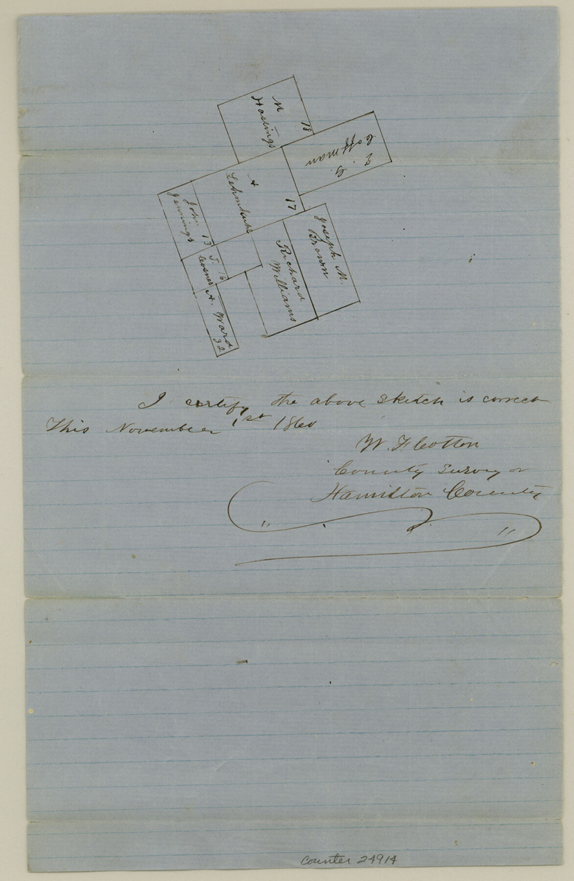
Hamilton County Sketch File 8
[Sketch of Survey 17, A. Lehmkupe and surrouding surveys]
-
Map/Doc
24914
-
Collection
General Map Collection
-
Object Dates
1860/11/1 (Creation Date)
1860/11/20 (File Date)
-
People and Organizations
W.F. Cotton (Surveyor/Engineer)
-
Counties
Hamilton
-
Subjects
Surveying Sketch File
-
Height x Width
12.2 x 8.0 inches
31.0 x 20.3 cm
-
Medium
paper, manuscript
Part of: General Map Collection
Menard County Working Sketch Graphic Index

Print $20.00
- Digital $50.00
Menard County Working Sketch Graphic Index
1942
Size 38.4 x 41.7 inches
Map/Doc 76640
McLennan County

Print $20.00
- Digital $50.00
McLennan County
1946
Size 42.3 x 45.1 inches
Map/Doc 77362
Duval County Rolled Sketch 46

Print $20.00
- Digital $50.00
Duval County Rolled Sketch 46
1985
Size 24.9 x 36.1 inches
Map/Doc 5761
Hardin County Rolled Sketch 22

Print $20.00
- Digital $50.00
Hardin County Rolled Sketch 22
1977
Size 32.0 x 44.4 inches
Map/Doc 9110
El Paso County Working Sketch 15

Print $40.00
- Digital $50.00
El Paso County Working Sketch 15
1957
Size 23.3 x 127.5 inches
Map/Doc 69037
[Map of Burnet County]
![4512, [Map of Burnet County], General Map Collection](https://historictexasmaps.com/wmedia_w700/maps/4512-2.tif.jpg)
Print $20.00
- Digital $50.00
[Map of Burnet County]
1856
Size 26.3 x 23.1 inches
Map/Doc 4512
DeWitt County Working Sketch 16

Print $20.00
- Digital $50.00
DeWitt County Working Sketch 16
1920
Size 23.0 x 25.1 inches
Map/Doc 69016
Burleson County Working Sketch 10

Print $3.00
- Digital $50.00
Burleson County Working Sketch 10
1980
Size 15.1 x 9.7 inches
Map/Doc 67729
Coast Chart No. 210 Aransas Pass and Corpus Christi Bay with the coast to latitude 27° 12' Texas

Print $20.00
- Digital $50.00
Coast Chart No. 210 Aransas Pass and Corpus Christi Bay with the coast to latitude 27° 12' Texas
1887
Size 27.2 x 18.2 inches
Map/Doc 72801
El Paso County Boundary File 7a

Print $20.00
- Digital $50.00
El Paso County Boundary File 7a
Size 14.2 x 8.3 inches
Map/Doc 53094
Blanco County Rolled Sketch 3

Print $20.00
- Digital $50.00
Blanco County Rolled Sketch 3
Size 14.8 x 13.5 inches
Map/Doc 5142
Map of the United States and Territories to accompany annual report of Hon. N.C. McFarland, Commissioner, General Land Office for fiscal year which ended June 30, 1884

Print $20.00
- Digital $50.00
Map of the United States and Territories to accompany annual report of Hon. N.C. McFarland, Commissioner, General Land Office for fiscal year which ended June 30, 1884
Size 27.0 x 39.3 inches
Map/Doc 96631
You may also like
Willacy County Working Sketch Graphic Index

Print $20.00
- Digital $50.00
Willacy County Working Sketch Graphic Index
1921
Size 32.8 x 32.7 inches
Map/Doc 76741
Collingsworth County Rolled Sketch 1

Print $40.00
- Digital $50.00
Collingsworth County Rolled Sketch 1
1941
Size 58.0 x 27.0 inches
Map/Doc 8637
Tyler County Working Sketch 20

Print $20.00
- Digital $50.00
Tyler County Working Sketch 20
1982
Size 41.0 x 32.7 inches
Map/Doc 69490
Duval County Sketch File 50

Print $8.00
- Digital $50.00
Duval County Sketch File 50
Size 9.4 x 7.9 inches
Map/Doc 21412
[Bastrop District]
![83519, [Bastrop District], General Map Collection](https://historictexasmaps.com/wmedia_w700/maps/83519-1.tif.jpg)
Print $20.00
- Digital $50.00
[Bastrop District]
1838
Size 26.5 x 44.2 inches
Map/Doc 83519
Corpus Christi Bay, Texas

Print $40.00
- Digital $50.00
Corpus Christi Bay, Texas
1867
Size 31.9 x 48.8 inches
Map/Doc 73468
Trinity River, Eagle Ford Sheet/Trinity and Elm Fork of Trinity River

Print $20.00
- Digital $50.00
Trinity River, Eagle Ford Sheet/Trinity and Elm Fork of Trinity River
1917
Size 29.5 x 23.2 inches
Map/Doc 69685
Free & Williams Subdivision of the north half of Outlots 56 and 57

Print $20.00
- Digital $50.00
Free & Williams Subdivision of the north half of Outlots 56 and 57
Size 10.9 x 29.5 inches
Map/Doc 475
Gregg County Working Sketch 2

Print $20.00
- Digital $50.00
Gregg County Working Sketch 2
1931
Size 16.8 x 13.6 inches
Map/Doc 63268
Presidio County Working Sketch 82

Print $40.00
- Digital $50.00
Presidio County Working Sketch 82
1967
Size 48.6 x 67.2 inches
Map/Doc 71759
Menard County Working Sketch 30

Print $20.00
- Digital $50.00
Menard County Working Sketch 30
1974
Size 47.9 x 38.8 inches
Map/Doc 70977
Trinity River, Carl Switch Sheet/Chambers Creek

Print $4.00
- Digital $50.00
Trinity River, Carl Switch Sheet/Chambers Creek
1926
Size 27.9 x 27.0 inches
Map/Doc 65217