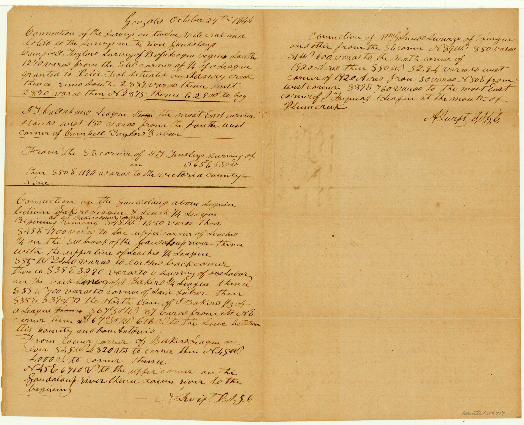
Guadalupe County Sketch File 25
[Field notes of connecting lines]
- 
                          Map/Doc
24717
 - 
                            Collection
General Map Collection
 - 
                            Object Dates
1984/11/27 (File Date)
 - 
                            People and Organizations
A. Swift (Surveyor/Engineer)
 - 
                            Counties
Guadalupe
 - 
                            Subjects
Surveying Sketch File
 - 
                            Height x Width
12.7 x 15.7 inches
32.3 x 39.9 cm
 - 
                            Medium
paper, manuscript
 - 
                            Features
Twelve Mile Creek
Coleto Creek
Guadalupe River
Sandy Creek
Plum Creek
 
Part of: General Map Collection
            Crane County Working Sketch 16


                                            Print $20.00                    
                                             -                         Digital $50.00                                    
                Crane County Working Sketch 16
1955
Size 42.8 x 22.0 inches
                                Map/Doc 68293
            
            Gaines County Sketch File 1


                                            Print $20.00                    
                                             -                         Digital $50.00                                    
                Gaines County Sketch File 1
Size 19.1 x 30.7 inches
                                Map/Doc 11521
            
            The American Military Pocket Atlas; being an approved Collection of Correct Maps, both general and particular, of the British Colonies; Especially those which now are, or probably may be the Theatre of War


            The American Military Pocket Atlas; being an approved Collection of Correct Maps, both general and particular, of the British Colonies; Especially those which now are, or probably may be the Theatre of War
1776
Map/Doc 97398
            
            Tarrant County Working Sketch 17


                                            Print $20.00                    
                                             -                         Digital $50.00                                    
                Tarrant County Working Sketch 17
1983
Size 24.6 x 20.7 inches
                                Map/Doc 62434
            
            Fannin County Sketch File 18


                                            Print $20.00                    
                                             -                         Digital $50.00                                    
                Fannin County Sketch File 18
1879
Size 16.7 x 22.2 inches
                                Map/Doc 11472
            
            Brewster County Rolled Sketch 22F


                                            Print $20.00                    
                                             -                         Digital $50.00                                    
                Brewster County Rolled Sketch 22F
1909
Size 19.0 x 25.4 inches
                                Map/Doc 5206
            
            Coast Chart No. 212 - From Latitude 26° 33' to the Rio Grande Texas


                                            Print $20.00                    
                                             -                         Digital $50.00                                    
                Coast Chart No. 212 - From Latitude 26° 33' to the Rio Grande Texas
1886
Size 27.2 x 18.2 inches
                                Map/Doc 72830
            
            Prison Property, Walker County


                                            Print $20.00                    
                                             -                         Digital $50.00                                    
                Prison Property, Walker County
Size 32.6 x 22.7 inches
                                Map/Doc 94279
            
            Map of Runnels County


                                            Print $20.00                    
                                             -                         Digital $50.00                                    
                Map of Runnels County
1898
Size 44.7 x 39.5 inches
                                Map/Doc 63008
            
            Galveston County NRC Article 33.136 Sketch 4


                                            Print $406.00                    
                                             -                         Digital $50.00                                    
                Galveston County NRC Article 33.136 Sketch 4
2001
Size 22.7 x 34.1 inches
                                Map/Doc 61568
            
            Atascosa County Working Sketch 33


                                            Print $20.00                    
                                             -                         Digital $50.00                                    
                Atascosa County Working Sketch 33
1982
Size 16.7 x 13.6 inches
                                Map/Doc 67229
            
            Val Verde County Sketch File 6 1/2


                                            Print $20.00                    
                                             -                         Digital $50.00                                    
                Val Verde County Sketch File 6 1/2
1882
Size 20.2 x 13.4 inches
                                Map/Doc 12563
            You may also like
            Polk County Working Sketch 20


                                            Print $40.00                    
                                             -                         Digital $50.00                                    
                Polk County Working Sketch 20
1952
Size 42.2 x 51.7 inches
                                Map/Doc 71635
            
            Nacogdoches County Working Sketch 8


                                            Print $20.00                    
                                             -                         Digital $50.00                                    
                Nacogdoches County Working Sketch 8
1964
Size 28.0 x 22.7 inches
                                Map/Doc 71224
            
            Presidio County Working Sketch 94


                                            Print $20.00                    
                                             -                         Digital $50.00                                    
                Presidio County Working Sketch 94
1976
Size 40.6 x 32.1 inches
                                Map/Doc 71771
            
            Atascosa County Working Sketch 35


                                            Print $20.00                    
                                             -                         Digital $50.00                                    
                Atascosa County Working Sketch 35
1992
Size 34.6 x 48.1 inches
                                Map/Doc 67231
            
            Hutchinson County Rolled Sketch 44-8


                                            Print $20.00                    
                                             -                         Digital $50.00                                    
                Hutchinson County Rolled Sketch 44-8
2002
Size 24.0 x 36.0 inches
                                Map/Doc 77544
            
            [T. & N. O. Railroad Company, Block 2T]


                                            Print $20.00                    
                                             -                         Digital $50.00                                    
                [T. & N. O. Railroad Company, Block 2T]
Size 30.6 x 9.5 inches
                                Map/Doc 91516
            
            San Augustine County Working Sketch 14


                                            Print $20.00                    
                                             -                         Digital $50.00                                    
                San Augustine County Working Sketch 14
1958
Size 22.7 x 26.1 inches
                                Map/Doc 63702
            
            Live Oak County Sketch File 11b


                                            Print $6.00                    
                                             -                         Digital $50.00                                    
                Live Oak County Sketch File 11b
Size 8.2 x 12.6 inches
                                Map/Doc 30267
            
            Fort Parker State Park


                                            Print $20.00                    
                                             -                         Digital $50.00                                    
                Fort Parker State Park
1950
Size 26.0 x 37.8 inches
                                Map/Doc 73569
            
            [H. & T. C. Block 34 and PSL Block B-19]


                                            Print $20.00                    
                                             -                         Digital $50.00                                    
                [H. & T. C. Block 34 and PSL Block B-19]
Size 30.6 x 30.6 inches
                                Map/Doc 91948
            
            Duval County Boundary File 3a


                                            Print $8.00                    
                                             -                         Digital $50.00                                    
                Duval County Boundary File 3a
Size 12.7 x 8.0 inches
                                Map/Doc 52726