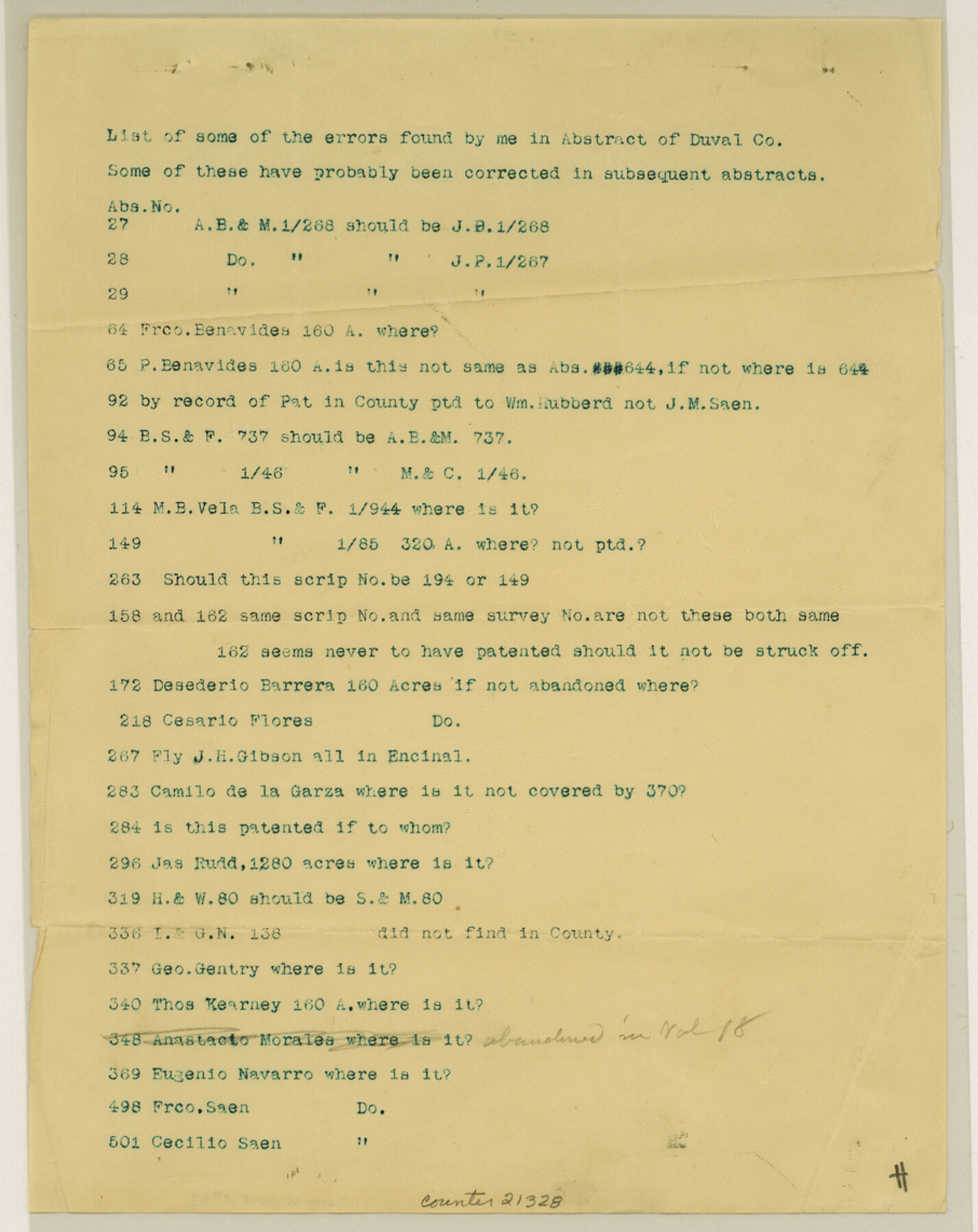
Duval County Sketch File 25
[List of errors in Duval County abstract number listings]
-
Map/Doc
21328
-
Collection
General Map Collection
-
Object Dates
1900/6/20 (File Date)
-
Counties
Duval Live Oak
-
Subjects
Surveying Sketch File
-
Height x Width
11.4 x 9.1 inches
29.0 x 23.1 cm
-
Medium
paper, print
-
Features
San Diego
Part of: General Map Collection
Reagan County Rolled Sketch 10

Print $20.00
- Digital $50.00
Reagan County Rolled Sketch 10
1939
Size 18.7 x 15.8 inches
Map/Doc 7438
Young County Sketch File 18

Print $10.00
- Digital $50.00
Young County Sketch File 18
1929
Size 11.5 x 8.7 inches
Map/Doc 40882
South Part Presidio County

Print $20.00
- Digital $50.00
South Part Presidio County
1975
Size 35.0 x 40.3 inches
Map/Doc 95617
Kendall County Working Sketch 4

Print $20.00
- Digital $50.00
Kendall County Working Sketch 4
1946
Size 25.7 x 24.3 inches
Map/Doc 66676

Refugio County Boundary File 74

Print $172.00
- Digital $50.00
Refugio County Boundary File 74
Size 9.3 x 4.4 inches
Map/Doc 58272
Henderson County Rolled Sketch 11

Print $20.00
- Digital $50.00
Henderson County Rolled Sketch 11
1915
Size 29.1 x 42.2 inches
Map/Doc 76150
Galveston County NRC Article 33.136 Sketch 24

Print $22.00
- Digital $50.00
Galveston County NRC Article 33.136 Sketch 24
2003
Size 24.8 x 36.3 inches
Map/Doc 87919
Kinney County Working Sketch 51

Print $20.00
- Digital $50.00
Kinney County Working Sketch 51
1980
Size 34.6 x 47.2 inches
Map/Doc 70233
Runnels County Working Sketch 15

Print $20.00
- Digital $50.00
Runnels County Working Sketch 15
1950
Size 22.8 x 18.5 inches
Map/Doc 63611
Liberty County Working Sketch 76

Print $4.00
- Digital $50.00
Liberty County Working Sketch 76
1980
Size 13.7 x 18.5 inches
Map/Doc 70536
Uvalde County Sketch File 31

Print $4.00
- Digital $50.00
Uvalde County Sketch File 31
Size 11.2 x 8.8 inches
Map/Doc 81529
You may also like
Index sheet to accompany map of survey for connecting the inland waters along margin of the Gulf of Mexico from Donaldsonville in Louisiana to the Rio Grande River in Texas

Print $20.00
- Digital $50.00
Index sheet to accompany map of survey for connecting the inland waters along margin of the Gulf of Mexico from Donaldsonville in Louisiana to the Rio Grande River in Texas
1874
Size 18.1 x 26.9 inches
Map/Doc 72694
Hudspeth County Working Sketch 44

Print $20.00
- Digital $50.00
Hudspeth County Working Sketch 44
1982
Size 25.5 x 22.2 inches
Map/Doc 66329
Flight Mission No. CRE-2R, Frame 87, Jackson County

Print $20.00
- Digital $50.00
Flight Mission No. CRE-2R, Frame 87, Jackson County
1956
Size 18.5 x 22.3 inches
Map/Doc 85359
Origins of Imports and Destination of Exports at Houston, Tex., during 1921

Print $20.00
- Digital $50.00
Origins of Imports and Destination of Exports at Houston, Tex., during 1921
1921
Size 14.2 x 23.1 inches
Map/Doc 97171
Fisher County Rolled Sketch 7

Print $20.00
- Digital $50.00
Fisher County Rolled Sketch 7
1873
Size 47.1 x 43.5 inches
Map/Doc 8891
General Highway Map, Harris County, Texas

Print $20.00
General Highway Map, Harris County, Texas
1961
Size 24.7 x 18.0 inches
Map/Doc 79501
Coleman County Working Sketch 8
Print $20.00
- Digital $50.00
Coleman County Working Sketch 8
1946
Size 39.3 x 33.3 inches
Map/Doc 68074
General Highway Map. Detail of Cities and Towns in Travis County, Texas. City Map, Austin and vicinity, Travis County, Texas

Print $20.00
General Highway Map. Detail of Cities and Towns in Travis County, Texas. City Map, Austin and vicinity, Travis County, Texas
1961
Size 18.2 x 25.0 inches
Map/Doc 79685
Brewster County Sketch File NS-14

Print $160.00
- Digital $50.00
Brewster County Sketch File NS-14
1970
Size 8.2 x 6.5 inches
Map/Doc 16224
[E. L. & R. R. RR. Co. Block D8 and vicinity]
![91863, [E. L. & R. R. RR. Co. Block D8 and vicinity], Twichell Survey Records](https://historictexasmaps.com/wmedia_w700/maps/91863-1.tif.jpg)
Print $20.00
- Digital $50.00
[E. L. & R. R. RR. Co. Block D8 and vicinity]
1891
Size 18.5 x 21.0 inches
Map/Doc 91863
El Nuevo México y Tierras Adyacentes Levantado para la Demarcación de los Límites de los Dominios Españoles y de los Estados Unidos

El Nuevo México y Tierras Adyacentes Levantado para la Demarcación de los Límites de los Dominios Españoles y de los Estados Unidos
1811
Size 9.4 x 12.6 inches
Map/Doc 94445
The Star of Llano County

Price $20.00
The Star of Llano County
2023
Size 3.3 x 2.8 inches
Map/Doc 97175