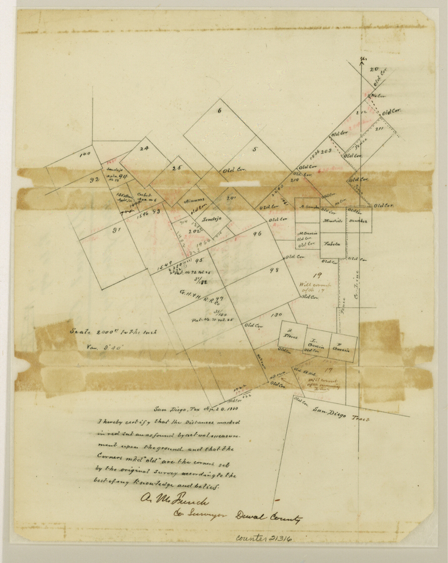
Duval County Sketch File 19
[Sketch of surveys surrounding G. H. & H. surveys 95 to 98]
-
Map/Doc
21316
-
Collection
General Map Collection
-
Object Dates
1880/4/20 (Creation Date)
1880/5/1 (File Date)
-
People and Organizations
A.M. French (Surveyor/Engineer)
-
Counties
Duval Jim Wells
-
Subjects
Surveying Sketch File
-
Height x Width
10.3 x 8.2 inches
26.2 x 20.8 cm
-
Medium
paper, manuscript
-
Scale
1:2000
Part of: General Map Collection
Crockett County Sketch File 95

Print $24.00
- Digital $50.00
Crockett County Sketch File 95
Size 11.2 x 8.9 inches
Map/Doc 19952
Orange County Working Sketch 33

Print $20.00
- Digital $50.00
Orange County Working Sketch 33
1957
Size 26.1 x 18.4 inches
Map/Doc 71365
[Surveys along the Pedernales River and Cypress Creek]
![121, [Surveys along the Pedernales River and Cypress Creek], General Map Collection](https://historictexasmaps.com/wmedia_w700/maps/121.tif.jpg)
Print $2.00
- Digital $50.00
[Surveys along the Pedernales River and Cypress Creek]
1841
Size 8.3 x 7.7 inches
Map/Doc 121
Stonewall County Working Sketch 12

Print $20.00
- Digital $50.00
Stonewall County Working Sketch 12
1950
Size 27.9 x 27.9 inches
Map/Doc 62319
Map of the County of Nueces

Print $20.00
- Digital $50.00
Map of the County of Nueces
1859
Size 39.3 x 39.6 inches
Map/Doc 78391
Palo Pinto County Working Sketch 26

Print $20.00
- Digital $50.00
Palo Pinto County Working Sketch 26
1993
Map/Doc 71409
Hutchinson County Rolled Sketch 43

Print $40.00
- Digital $50.00
Hutchinson County Rolled Sketch 43
1992
Size 40.5 x 49.4 inches
Map/Doc 6312
Webb County Sketch File 8a

Print $4.00
- Digital $50.00
Webb County Sketch File 8a
Size 7.9 x 8.7 inches
Map/Doc 39743
Tarrant County Sketch File 26

Print $24.00
- Digital $50.00
Tarrant County Sketch File 26
1874
Size 12.7 x 8.4 inches
Map/Doc 37739
Bexar County Working Sketch 19

Print $20.00
- Digital $50.00
Bexar County Working Sketch 19
1982
Size 41.8 x 41.7 inches
Map/Doc 67335
Gillespie County

Print $20.00
- Digital $50.00
Gillespie County
1918
Size 35.8 x 47.4 inches
Map/Doc 81950
Flight Mission No. BRA-8M, Frame 71, Jefferson County

Print $20.00
- Digital $50.00
Flight Mission No. BRA-8M, Frame 71, Jefferson County
1953
Size 18.7 x 22.3 inches
Map/Doc 85591
You may also like
Colorado County Working Sketch 4

Print $20.00
- Digital $50.00
Colorado County Working Sketch 4
1913
Size 23.2 x 16.9 inches
Map/Doc 68104
Flight Mission No. DQN-2K, Frame 138, Calhoun County

Print $20.00
- Digital $50.00
Flight Mission No. DQN-2K, Frame 138, Calhoun County
1953
Size 16.1 x 16.0 inches
Map/Doc 84307
The Brownsville District of the Famous Lower Rio Grande Valley - The Texas Tropics

The Brownsville District of the Famous Lower Rio Grande Valley - The Texas Tropics
1920
Map/Doc 96732
Jack County Sketch File 15

Print $4.00
- Digital $50.00
Jack County Sketch File 15
1880
Size 7.3 x 13.7 inches
Map/Doc 27545
Winkler County Rolled Sketch 16

Print $20.00
- Digital $50.00
Winkler County Rolled Sketch 16
1927
Size 22.5 x 32.6 inches
Map/Doc 8276
Dallam County

Print $20.00
- Digital $50.00
Dallam County
1888
Size 29.4 x 23.9 inches
Map/Doc 90641
Dickens County Sketch File O

Print $8.00
- Digital $50.00
Dickens County Sketch File O
1903
Size 13.3 x 8.7 inches
Map/Doc 20944
Edwards County Working Sketch 52

Print $20.00
- Digital $50.00
Edwards County Working Sketch 52
1950
Size 46.8 x 34.1 inches
Map/Doc 68928
Potter County Working Sketch 12

Print $40.00
- Digital $50.00
Potter County Working Sketch 12
1972
Size 64.4 x 42.4 inches
Map/Doc 71672
Map of the Southern part of Texas

Print $20.00
- Digital $50.00
Map of the Southern part of Texas
1831
Size 17.5 x 21.3 inches
Map/Doc 94442
Harris County Rolled Sketch T1

Print $20.00
- Digital $50.00
Harris County Rolled Sketch T1
1916
Size 29.8 x 24.3 inches
Map/Doc 6144
Runnels County Rolled Sketch 29

Print $20.00
- Digital $50.00
Runnels County Rolled Sketch 29
1928
Size 19.6 x 37.0 inches
Map/Doc 7517