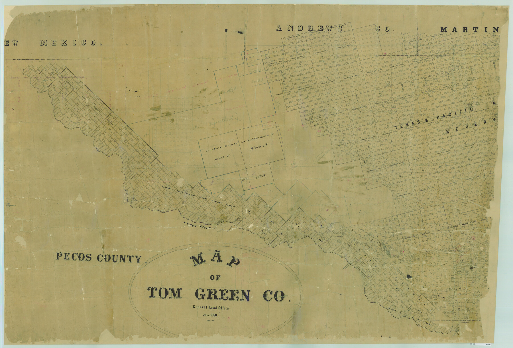
Map of Tom Green Co.
-
Map/Doc
16899
-
Collection
General Map Collection
-
Object Dates
1880 (Creation Date)
-
People and Organizations
Texas General Land Office (Publisher)
Louis C. Wise (Compiler)
Louis C. Wise (Draftsman)
-
Counties
Tom Green
-
Subjects
County
-
Height x Width
41.9 x 61.8 inches
106.4 x 157.0 cm
-
Comments
See 80136 for east part, and 81917 for a digital compost of these two parts.
Conservation funded in 2003 with donations from The Summerlee Foundation, Drake Davis, and Emil F. Beck for Odes -
Features
Shafter Trail
Pontoon Bridge
Pecos Station
Aroya
Lagenda
Midway
Carson
Odessa
Duero
Mustang Creek
Horsehead Crossing
Castle Gap
Wild China Water Holes
Pecos River
Pecos City
Pyote
Sand Hills
Salt Lake
Related maps
Map of Tom Green Co.

Print $40.00
- Digital $50.00
Map of Tom Green Co.
1880
Size 42.3 x 51.2 inches
Map/Doc 80136
Map of Tom Green Co.

Print $40.00
- Digital $50.00
Map of Tom Green Co.
1880
Size 42.7 x 109.3 inches
Map/Doc 81917
Part of: General Map Collection
Flight Mission No. DIX-10P, Frame 169, Aransas County

Print $20.00
- Digital $50.00
Flight Mission No. DIX-10P, Frame 169, Aransas County
1956
Size 18.7 x 22.3 inches
Map/Doc 83959
Flight Mission No. CGI-3N, Frame 79, Cameron County

Print $20.00
- Digital $50.00
Flight Mission No. CGI-3N, Frame 79, Cameron County
1954
Size 18.6 x 22.4 inches
Map/Doc 84573
Die Vereinigten Staaten v. Nord-America

Print $20.00
- Digital $50.00
Die Vereinigten Staaten v. Nord-America
1846
Size 21.0 x 27.9 inches
Map/Doc 94513
Rusk County Sketch File 12

Print $6.00
- Digital $50.00
Rusk County Sketch File 12
1845
Size 8.4 x 7.9 inches
Map/Doc 35511
Orange County Working Sketch 8

Print $20.00
- Digital $50.00
Orange County Working Sketch 8
1922
Size 20.7 x 24.3 inches
Map/Doc 71340
Bastrop County Boundary File 6

Print $40.00
- Digital $50.00
Bastrop County Boundary File 6
1923
Size 15.4 x 102.0 inches
Map/Doc 1691
Rusk County Sketch File 36

Print $20.00
Rusk County Sketch File 36
1950
Size 23.8 x 18.0 inches
Map/Doc 12274
Crockett County Working Sketch 76

Print $20.00
- Digital $50.00
Crockett County Working Sketch 76
1964
Size 34.3 x 36.3 inches
Map/Doc 68409
El Paso County Rolled Sketch 40

Print $20.00
- Digital $50.00
El Paso County Rolled Sketch 40
1929
Size 43.6 x 25.2 inches
Map/Doc 5827
FT. W. & R. G. Ry. Right of Way Map, Winchell to Brady, McCulloch County, Texas

Print $40.00
- Digital $50.00
FT. W. & R. G. Ry. Right of Way Map, Winchell to Brady, McCulloch County, Texas
1918
Size 38.0 x 121.9 inches
Map/Doc 61410
The United States of America

Print $20.00
- Digital $50.00
The United States of America
1866
Size 22.4 x 18.2 inches
Map/Doc 72645
Dimmit County Working Sketch 17

Print $20.00
- Digital $50.00
Dimmit County Working Sketch 17
1943
Size 27.4 x 24.7 inches
Map/Doc 68678
You may also like
Bandera County Rolled Sketch 13

Print $20.00
- Digital $50.00
Bandera County Rolled Sketch 13
2018
Size 24.1 x 20.5 inches
Map/Doc 95305
Map of Bexar County

Print $20.00
- Digital $50.00
Map of Bexar County
1845
Size 47.4 x 44.9 inches
Map/Doc 87234
The Republic County of Shelby. January 28, 1839

Print $20.00
The Republic County of Shelby. January 28, 1839
2020
Size 21.1 x 21.7 inches
Map/Doc 96281
Bandera County Working Sketch 10

Print $20.00
- Digital $50.00
Bandera County Working Sketch 10
1922
Size 17.9 x 19.4 inches
Map/Doc 67603
[Notes and map showing Public School Land Block K between Yoakum and Terry Counties]
![92011, [Notes and map showing Public School Land Block K between Yoakum and Terry Counties], Twichell Survey Records](https://historictexasmaps.com/wmedia_w700/maps/92011-1.tif.jpg)
Print $20.00
- Digital $50.00
[Notes and map showing Public School Land Block K between Yoakum and Terry Counties]
1902
Size 17.1 x 30.9 inches
Map/Doc 92011
Angelina County Sketch File 18b

Print $40.00
- Digital $50.00
Angelina County Sketch File 18b
Size 12.6 x 16.2 inches
Map/Doc 13032
The Making of America - Northern Plains

The Making of America - Northern Plains
Size 20.7 x 27.3 inches
Map/Doc 95943
Potter County Working Sketch 12

Print $40.00
- Digital $50.00
Potter County Working Sketch 12
1972
Size 64.4 x 42.4 inches
Map/Doc 71672
Shackelford County Boundary File 2

Print $88.00
- Digital $50.00
Shackelford County Boundary File 2
Size 8.7 x 5.3 inches
Map/Doc 58633
Working Sketch in Eastland County

Print $20.00
- Digital $50.00
Working Sketch in Eastland County
1919
Size 20.1 x 14.6 inches
Map/Doc 90931
Carson County

Print $20.00
- Digital $50.00
Carson County
1932
Size 38.2 x 35.0 inches
Map/Doc 77232
Henderson County Working Sketch 26

Print $20.00
- Digital $50.00
Henderson County Working Sketch 26
1954
Size 23.8 x 23.5 inches
Map/Doc 66159