Coke County Sketch File AB
[Connecting line and explanation regarding surveys in southwestern part of the county]
-
Map/Doc
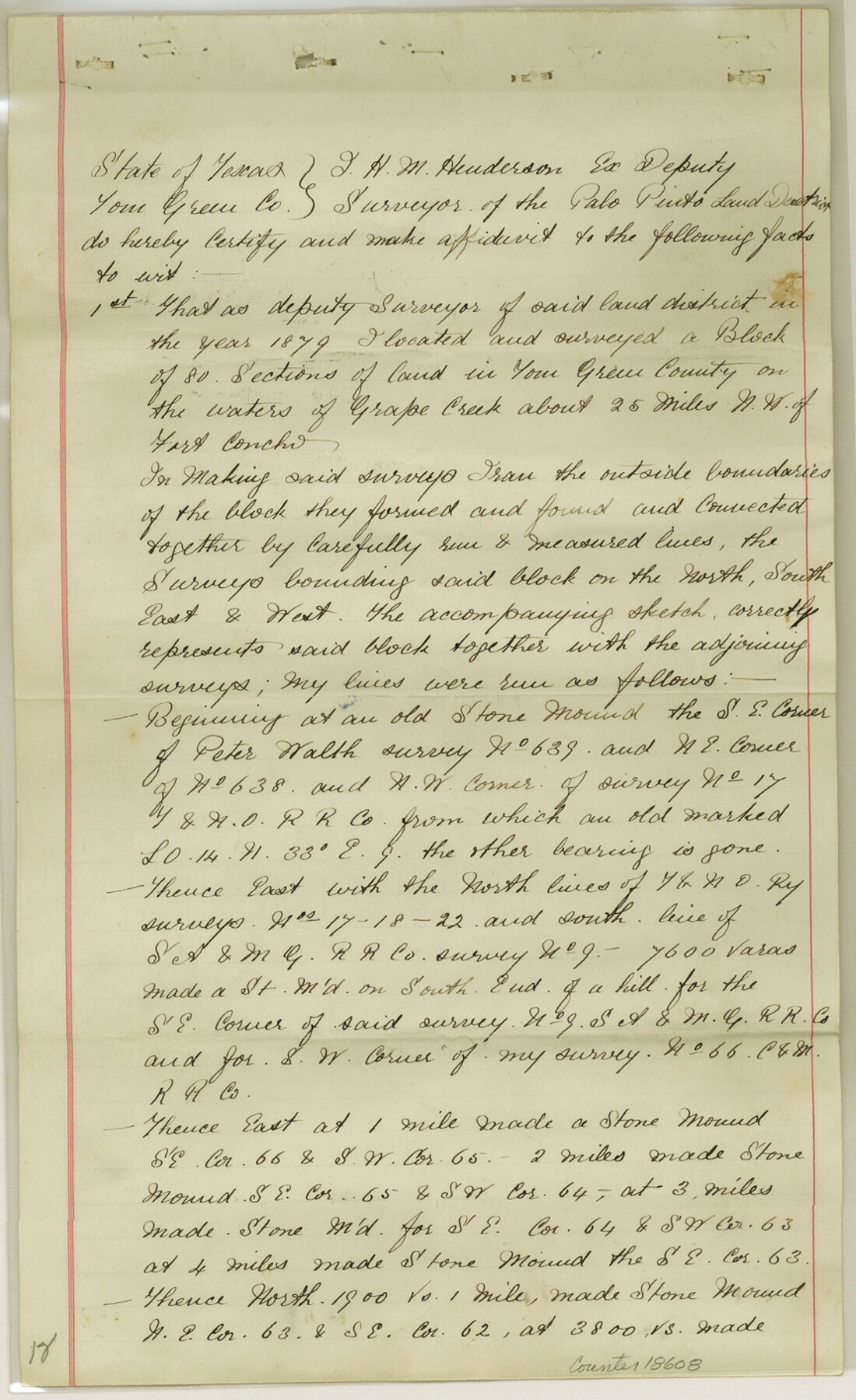
18608
-
Collection
General Map Collection
-
Object Dates
1884/2/27 (Creation Date)
1903/9/30 (File Date)
1879 (Survey Date)
-
People and Organizations
H.M. Henderson (Surveyor/Engineer)
-
Counties
Coke Tom Green
-
Subjects
Surveying Sketch File
-
Height x Width
14.1 x 8.7 inches
35.8 x 22.1 cm
-
Medium
paper, manuscript
-
Features
Grape Creek
Fort Concho
Butterfield Canon [sic]
80 Mile Reserve
Part of: General Map Collection
Reeves County Working Sketch 52

Print $40.00
- Digital $50.00
Reeves County Working Sketch 52
1977
Size 60.3 x 41.9 inches
Map/Doc 63495
Travis County Sketch File 74

Print $10.00
- Digital $50.00
Travis County Sketch File 74
1992
Size 11.5 x 8.8 inches
Map/Doc 38468

El Paso County Boundary File 16

Print $6.00
- Digital $50.00
El Paso County Boundary File 16
Size 14.0 x 8.5 inches
Map/Doc 53189
Panola County Sketch File 2

Print $4.00
- Digital $50.00
Panola County Sketch File 2
1851
Size 10.8 x 8.2 inches
Map/Doc 33447
Jeff Davis County Rolled Sketch 13A

Print $20.00
- Digital $50.00
Jeff Davis County Rolled Sketch 13A
1921
Size 19.0 x 23.1 inches
Map/Doc 6367
Map of Fayette County

Print $20.00
- Digital $50.00
Map of Fayette County
1843
Size 21.9 x 26.7 inches
Map/Doc 3537
Burleson County Working Sketch 4

Print $20.00
- Digital $50.00
Burleson County Working Sketch 4
1979
Size 33.3 x 35.6 inches
Map/Doc 67723
Starr County Sketch File 23

Print $16.00
- Digital $50.00
Starr County Sketch File 23
1922
Size 10.7 x 8.8 inches
Map/Doc 36919
Mitchell County Boundary File 66a

Print $11.00
- Digital $50.00
Mitchell County Boundary File 66a
Size 12.6 x 8.3 inches
Map/Doc 57378
United States - Gulf Coast Texas - Northern part of Laguna Madre

Print $20.00
- Digital $50.00
United States - Gulf Coast Texas - Northern part of Laguna Madre
1941
Size 18.3 x 24.0 inches
Map/Doc 72937
El Paso County Sketch File 35 (4)

Print $38.00
- Digital $50.00
El Paso County Sketch File 35 (4)
1886
Size 14.3 x 9.0 inches
Map/Doc 22199
You may also like

Colton's rail road and county map of the southern states containing the latest information.

Print $20.00
Colton's rail road and county map of the southern states containing the latest information.
1864
Size 24.4 x 31.1 inches
Map/Doc 93570
Carta Historica y Arqueologica

Print $20.00
- Digital $50.00
Carta Historica y Arqueologica
Size 26.0 x 34.4 inches
Map/Doc 96806
Galveston to Rio Grande

Print $20.00
- Digital $50.00
Galveston to Rio Grande
1941
Size 43.7 x 37.1 inches
Map/Doc 69957
Baylor County Sketch File 14

Print $4.00
- Digital $50.00
Baylor County Sketch File 14
1879
Size 13.0 x 8.2 inches
Map/Doc 14181
Schleicher County

Print $20.00
- Digital $50.00
Schleicher County
1940
Size 28.8 x 41.2 inches
Map/Doc 77418
Dimmit County Sketch File 21a

Print $12.00
- Digital $50.00
Dimmit County Sketch File 21a
1901
Size 8.9 x 7.8 inches
Map/Doc 21123
United States - Gulf Coast - From Latitude 26° 33' to the Rio Grande Texas

Print $20.00
- Digital $50.00
United States - Gulf Coast - From Latitude 26° 33' to the Rio Grande Texas
1918
Size 18.3 x 24.1 inches
Map/Doc 72845
Dawson County Working Sketch 13

Print $20.00
- Digital $50.00
Dawson County Working Sketch 13
1952
Size 18.1 x 12.6 inches
Map/Doc 68557
Railroad Track Map, H&TCRRCo., Falls County, Texas

Print $4.00
- Digital $50.00
Railroad Track Map, H&TCRRCo., Falls County, Texas
1918
Size 11.3 x 18.5 inches
Map/Doc 62847
Archer County Sketch File 25

Print $40.00
- Digital $50.00
Archer County Sketch File 25
Size 22.3 x 46.6 inches
Map/Doc 10348
Working Sketch Cochran and Yoakum Co's.

Print $40.00
- Digital $50.00
Working Sketch Cochran and Yoakum Co's.
1919
Size 54.5 x 16.4 inches
Map/Doc 89676