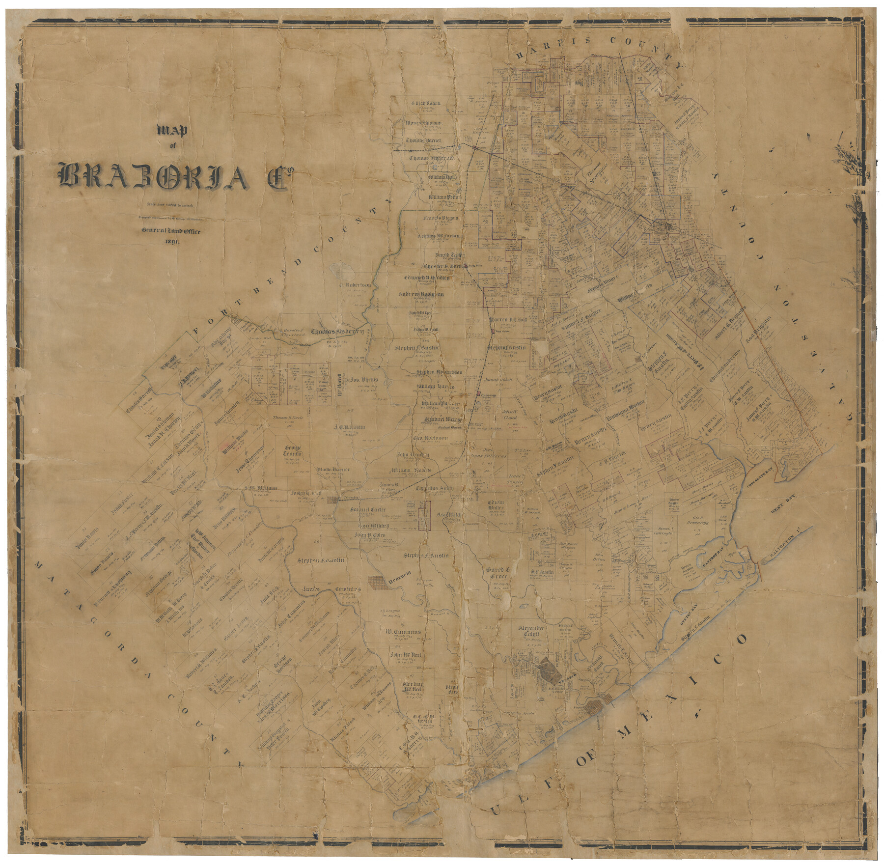
Map of Brazoria County
-
Map/Doc
16945
-
Collection
General Map Collection
-
Object Dates
1891 (Creation Date)
-
People and Organizations
Schutze (Draftsman)
-
Counties
Brazoria
-
Subjects
County
-
Height x Width
56.9 x 58.4 inches
144.5 x 148.3 cm
-
Comments
Conservation funded by Friends of the Texas General Land Office in 2003.
Digitized in 2012 with a generous grant from the Summerlee Foundation. -
Features
Oyster Bay
Varner's Creek
Columbia
Chocolate Bay
West Bay
North Creek
Oyster Creek
Bastrop Bayou
Bastrop Bay
Mudd [sic] Island
Galveston Island
Buffalo Creek
Brazoria
Mustang Bayou
Gulf of Mexico
Orum Point
Matagorda Bay
Jones Creek
Velasco
East Union Bayou
[Oyster Creek] Canal
Quintana
West Union Bayou
Cedar Lake Bayou
Cedar Lake
Flores Bayou
China Grove
Flat Bank Bayou
Ariola
Long Point Creek
Clear Lake
Mill Lake
GC&SF
Mustang
Cow Bayou
Big Lake
Alvin
Sandy Point
Bee Creek
Clear Creek
Liverpool
Brazos River
Cow Creek
Mound Creek
I&GN
Halls Bayou
Chenango
San Bernardo River
Austin Bayou
Chocolate Bayou
New Creek
Part of: General Map Collection
Armstrong County Sketch File 8

Print $8.00
- Digital $50.00
Armstrong County Sketch File 8
Size 14.2 x 8.8 inches
Map/Doc 13705
Marion County Boundary File 1

Print $14.00
- Digital $50.00
Marion County Boundary File 1
Size 12.9 x 8.2 inches
Map/Doc 56822
Kent County Boundary File 1

Print $54.00
- Digital $50.00
Kent County Boundary File 1
Size 14.2 x 8.5 inches
Map/Doc 55795
Anderson County Working Sketch 44

Print $20.00
- Digital $50.00
Anderson County Working Sketch 44
1991
Size 27.7 x 32.3 inches
Map/Doc 67044
Intracoastal Waterway in Texas - Corpus Christi to Point Isabel including Arroyo Colorado to Mo. Pac. R.R. Bridge Near Harlingen

Print $20.00
- Digital $50.00
Intracoastal Waterway in Texas - Corpus Christi to Point Isabel including Arroyo Colorado to Mo. Pac. R.R. Bridge Near Harlingen
1934
Size 21.8 x 32.7 inches
Map/Doc 61885
Crockett County Working Sketch 24

Print $20.00
- Digital $50.00
Crockett County Working Sketch 24
1920
Size 43.0 x 17.7 inches
Map/Doc 68357
Hale County Boundary File 9

Print $68.00
- Digital $50.00
Hale County Boundary File 9
Size 14.2 x 8.8 inches
Map/Doc 54111
Webb County Sketch File 4

Print $22.00
- Digital $50.00
Webb County Sketch File 4
1855
Size 8.4 x 14.2 inches
Map/Doc 39716
South Sulphur River, Bonner Point Sheet

Print $20.00
- Digital $50.00
South Sulphur River, Bonner Point Sheet
1922
Size 32.9 x 35.7 inches
Map/Doc 65164
Map of Hutchinson County

Print $20.00
- Digital $50.00
Map of Hutchinson County
1898
Size 41.0 x 35.4 inches
Map/Doc 16856
Fannin County Working Sketch 8

Print $20.00
- Digital $50.00
Fannin County Working Sketch 8
1955
Size 27.2 x 16.0 inches
Map/Doc 69162
[Map of] North America
![88884, [Map of] North America, General Map Collection](https://historictexasmaps.com/wmedia_w700/maps/88884.tif.jpg)
Print $3.00
- Digital $50.00
[Map of] North America
1834
Size 11.0 x 8.5 inches
Map/Doc 88884
You may also like
Crosby County Working Sketch 12

Print $20.00
- Digital $50.00
Crosby County Working Sketch 12
1953
Size 26.0 x 29.8 inches
Map/Doc 68446

[Stone, Kyle and Kyle Block M6]
![90392, [Stone, Kyle and Kyle Block M6], Twichell Survey Records](https://historictexasmaps.com/wmedia_w700/maps/90392-1.tif.jpg)
Print $3.00
- Digital $50.00
[Stone, Kyle and Kyle Block M6]
Size 11.9 x 15.2 inches
Map/Doc 90392
Flight Mission No. BRA-9M, Frame 59, Jefferson County

Print $20.00
- Digital $50.00
Flight Mission No. BRA-9M, Frame 59, Jefferson County
1953
Size 18.6 x 22.4 inches
Map/Doc 85642
Davis Mountains State Park Area Showing Scenic Drive

Print $20.00
Davis Mountains State Park Area Showing Scenic Drive
1935
Size 26.9 x 34.5 inches
Map/Doc 76312
Harrison County

Print $20.00
- Digital $50.00
Harrison County
1920
Size 43.0 x 40.0 inches
Map/Doc 77305
In the Supreme Court of the United States, The State of Oklahoma, Complainant vs. The State of Texas, Defendant, The United States of America, Intervener, Red River Valley, Texas and Oklahoma Between the 98th and 100th Meridians in Five Sheets, 1921

Print $40.00
- Digital $50.00
In the Supreme Court of the United States, The State of Oklahoma, Complainant vs. The State of Texas, Defendant, The United States of America, Intervener, Red River Valley, Texas and Oklahoma Between the 98th and 100th Meridians in Five Sheets, 1921
1921
Size 37.1 x 60.6 inches
Map/Doc 75278
Brazoria County Working Sketch 30

Print $20.00
- Digital $50.00
Brazoria County Working Sketch 30
1974
Size 37.5 x 43.8 inches
Map/Doc 67515
Map of Mason County

Print $20.00
- Digital $50.00
Map of Mason County
1877
Size 25.3 x 19.9 inches
Map/Doc 3836
[Randall County]
![92970, [Randall County], Twichell Survey Records](https://historictexasmaps.com/wmedia_w700/maps/92970-1.tif.jpg)
Print $20.00
- Digital $50.00
[Randall County]
Size 14.7 x 12.0 inches
Map/Doc 92970
Marion County Rolled Sketch 2

Print $40.00
- Digital $50.00
Marion County Rolled Sketch 2
1954
Size 89.3 x 45.7 inches
Map/Doc 63912
Flight Mission No. CGI-8AA, Frame 146, Cameron County

Print $20.00
- Digital $50.00
Flight Mission No. CGI-8AA, Frame 146, Cameron County
1962
Size 18.6 x 18.3 inches
Map/Doc 84533