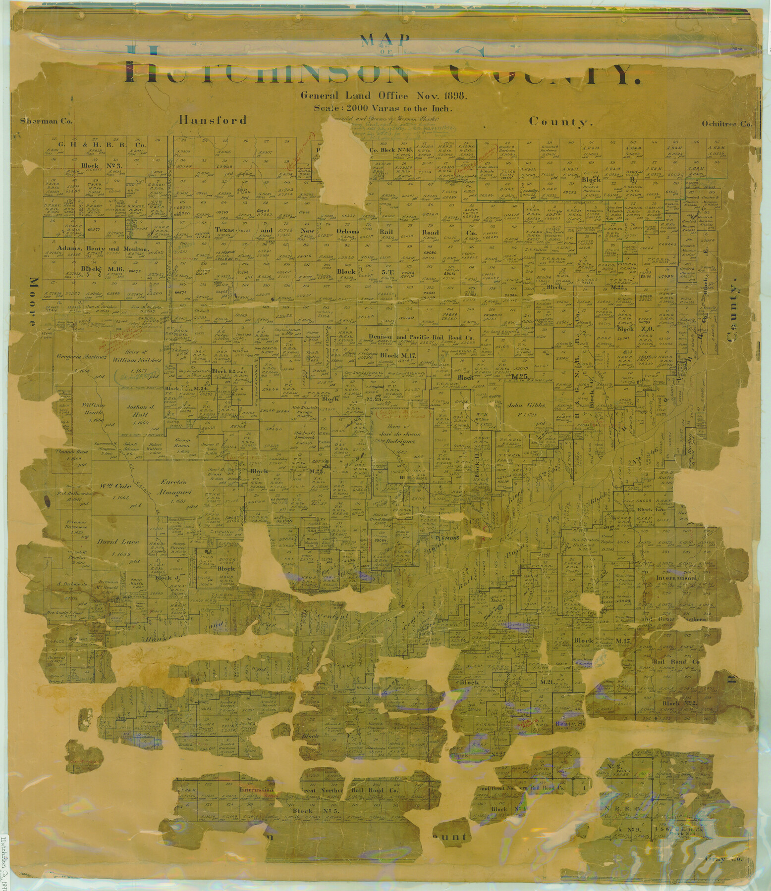
Map of Hutchinson County
-
Map/Doc
16856
-
Collection
General Map Collection
-
Object Dates
1898 (Creation Date)
-
People and Organizations
Texas General Land Office (Publisher)
Herman Pressler (Draftsman)
Herman Pressler (Compiler)
-
Counties
Hutchinson
-
Subjects
County
-
Height x Width
41.0 x 35.4 inches
104.1 x 89.9 cm
-
Comments
Help Save Texas History - Adopt Me!
-
Features
Plemons
Bents Creek
Rock Creek
Bear Creek
Dixon Creek
Limestone Creek
Antelope Creek
Canadian River
Spring Creek
Cottonwood Creek
Willow Creek
Moore's Creek
Bugbee Creek
White Deer Creek
Timber Creek
Adobewalls
Bents Fort
Cold Water Creek
Kit Carson Creek
Adobe Creek
Part of: General Map Collection

Flight Mission No. DQO-2K, Frame 93, Galveston County

Print $20.00
- Digital $50.00
Flight Mission No. DQO-2K, Frame 93, Galveston County
1952
Size 18.8 x 22.4 inches
Map/Doc 85020
Map of Padre Island Showing Location of Zoning Districts

Print $20.00
- Digital $50.00
Map of Padre Island Showing Location of Zoning Districts
1971
Size 26.4 x 18.8 inches
Map/Doc 4813
Upton County Rolled Sketch 56

Print $158.00
- Digital $50.00
Upton County Rolled Sketch 56
1934
Size 10.0 x 15.1 inches
Map/Doc 49413
Brazoria County Sketch File 57

Print $10.00
- Digital $50.00
Brazoria County Sketch File 57
1940
Size 8.7 x 6.3 inches
Map/Doc 15377
Smith County Working Sketch Graphic Index

Print $20.00
- Digital $50.00
Smith County Working Sketch Graphic Index
1948
Size 44.7 x 41.1 inches
Map/Doc 76699
Dimmit County Sketch File 59

Print $26.00
- Digital $50.00
Dimmit County Sketch File 59
1912
Size 14.4 x 8.9 inches
Map/Doc 21193
Jack County Sketch File 9a

Print $6.00
- Digital $50.00
Jack County Sketch File 9a
1857
Size 12.5 x 7.8 inches
Map/Doc 27522
Crane County Sketch File 20

Print $8.00
- Digital $50.00
Crane County Sketch File 20
1928
Size 11.0 x 8.5 inches
Map/Doc 19586
Wichita County Sketch File 1

Print $22.00
- Digital $50.00
Wichita County Sketch File 1
1856
Size 13.5 x 16.8 inches
Map/Doc 40028
Morris County Working Sketch 5

Print $20.00
- Digital $50.00
Morris County Working Sketch 5
1965
Size 24.7 x 18.9 inches
Map/Doc 71204
Tyler County Rolled Sketch 10

Print $40.00
- Digital $50.00
Tyler County Rolled Sketch 10
1982
Size 48.7 x 35.4 inches
Map/Doc 10032
You may also like
Mapa de los Estados Unidos Mejicanos arreglado a la distribucion que en diversos decretos ha hecho del territorio el Congreso General Mejicano

Print $20.00
- Digital $50.00
Mapa de los Estados Unidos Mejicanos arreglado a la distribucion que en diversos decretos ha hecho del territorio el Congreso General Mejicano
1851
Size 24.6 x 30.3 inches
Map/Doc 96514
A Map of Dallas County

Print $20.00
- Digital $50.00
A Map of Dallas County
1855
Size 18.4 x 18.8 inches
Map/Doc 3465
Coryell County Working Sketch 14

Print $20.00
- Digital $50.00
Coryell County Working Sketch 14
1950
Size 19.4 x 17.5 inches
Map/Doc 68221
Flight Mission No. DCL-7C, Frame 40, Kenedy County

Print $20.00
- Digital $50.00
Flight Mission No. DCL-7C, Frame 40, Kenedy County
1943
Size 15.4 x 15.2 inches
Map/Doc 86028
Liberty County Rolled Sketch N

Print $20.00
- Digital $50.00
Liberty County Rolled Sketch N
Size 44.7 x 38.5 inches
Map/Doc 10180
Gaines County Sketch

Print $20.00
- Digital $50.00
Gaines County Sketch
1950
Size 13.6 x 18.7 inches
Map/Doc 92674
Val Verde County Rolled Sketch 60

Print $20.00
- Digital $50.00
Val Verde County Rolled Sketch 60
1951
Size 32.4 x 20.4 inches
Map/Doc 8127
Texas Intracoastal Waterway - Laguna Madre - Dagger Hill to Potrero Grande

Print $20.00
- Digital $50.00
Texas Intracoastal Waterway - Laguna Madre - Dagger Hill to Potrero Grande
Size 39.0 x 27.3 inches
Map/Doc 73508
Boundary and Ownership map, Laguna Atascosa National Wildlife Refuge, Cameron and Willacy Counties, Texas

Print $40.00
- Digital $50.00
Boundary and Ownership map, Laguna Atascosa National Wildlife Refuge, Cameron and Willacy Counties, Texas
Size 72.7 x 43.0 inches
Map/Doc 60396

[Surveys near Keechi Creek and the Trinity River]
![47, [Surveys near Keechi Creek and the Trinity River], General Map Collection](https://historictexasmaps.com/wmedia_w700/maps/47.tif.jpg)
Print $2.00
- Digital $50.00
[Surveys near Keechi Creek and the Trinity River]
1841
Size 8.6 x 8.2 inches
Map/Doc 47
Map of Wood County Showing Location of the Texas and Pacific Railway

Print $20.00
- Digital $50.00
Map of Wood County Showing Location of the Texas and Pacific Railway
1872
Size 19.1 x 23.8 inches
Map/Doc 64135