Brewster County Sketch File 15
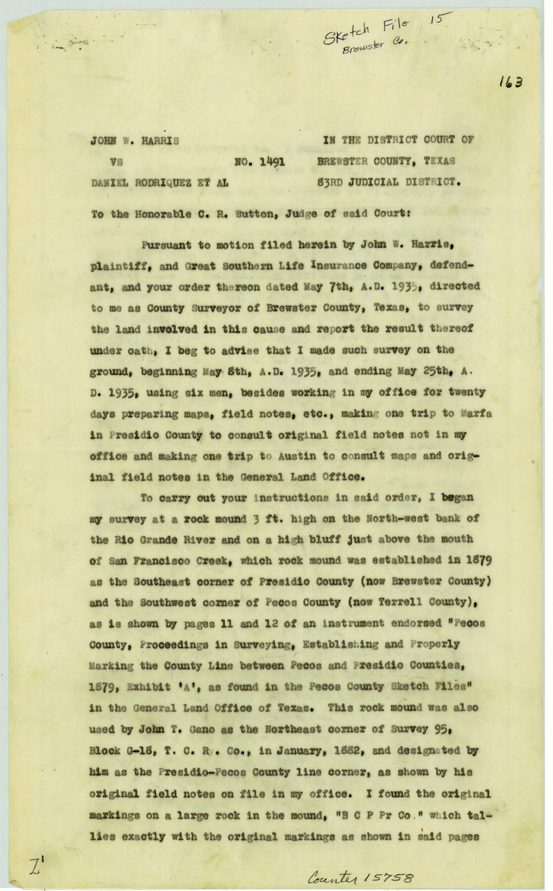
[Report and sketch relating to Cause No. 1491 - John W. Harris vs. D. Rodriquez et al, 83rd Judicial District Court of Brewster County]
-
Map/Doc
15758
-
Collection
General Map Collection
-
Object Dates
1935/5/25 (Creation Date)
1939/4/6 (File Date)
1935/5/8 (Survey Date)
-
People and Organizations
H.R. Gard (Surveyor/Engineer)
-
Counties
Brewster Terrell
-
Subjects
Surveying Sketch File
-
Height x Width
14.2 x 8.8 inches
36.1 x 22.4 cm
-
Medium
paper, print
-
Comments
Also see Brewster County Sketch File 16 (15777).
-
Features
Marfa
Rio Grande River
San Francisco Creek
Javalina Canyon
Schupbach Road
Bootlegger's Trail
Spring Creek Trail
Meyers Spring
Jesus Trail
Related maps
Brewster County Sketch File 16

Print $46.00
- Digital $50.00
Brewster County Sketch File 16
1936
Size 14.3 x 8.6 inches
Map/Doc 15777
Part of: General Map Collection
Upper Galveston Bay, Houston Ship Channel, Dollar Pt. to Atkinson I.

Print $40.00
- Digital $50.00
Upper Galveston Bay, Houston Ship Channel, Dollar Pt. to Atkinson I.
1973
Size 49.8 x 36.8 inches
Map/Doc 69896
Flight Mission No. BQR-5K, Frame 61, Brazoria County

Print $20.00
- Digital $50.00
Flight Mission No. BQR-5K, Frame 61, Brazoria County
1952
Size 18.9 x 22.5 inches
Map/Doc 84006
Cooke County Working Sketch 20

Print $20.00
- Digital $50.00
Cooke County Working Sketch 20
1956
Size 21.1 x 10.4 inches
Map/Doc 68257
Flight Mission No. BRE-2P, Frame 66, Nueces County

Print $20.00
- Digital $50.00
Flight Mission No. BRE-2P, Frame 66, Nueces County
1956
Size 18.6 x 22.5 inches
Map/Doc 86761
Freestone County Sketch File 2

Print $12.00
- Digital $50.00
Freestone County Sketch File 2
1849
Size 13.0 x 8.1 inches
Map/Doc 23037
Milam County Sketch File 2

Print $4.00
- Digital $50.00
Milam County Sketch File 2
1849
Size 8.0 x 12.4 inches
Map/Doc 31627
Chambers County Sketch File 13

Print $6.00
- Digital $50.00
Chambers County Sketch File 13
1873
Size 9.8 x 12.4 inches
Map/Doc 17558
Polk County Working Sketch 2

Print $20.00
- Digital $50.00
Polk County Working Sketch 2
1909
Size 27.7 x 20.1 inches
Map/Doc 71617
La Salle County Rolled Sketch 6

Print $40.00
- Digital $50.00
La Salle County Rolled Sketch 6
1941
Size 43.0 x 66.0 inches
Map/Doc 10738
San Augustine County Working Sketch 9

Print $20.00
- Digital $50.00
San Augustine County Working Sketch 9
1935
Size 41.2 x 39.7 inches
Map/Doc 63696
Fort Bend Co.

Print $20.00
- Digital $50.00
Fort Bend Co.
1931
Size 40.5 x 41.3 inches
Map/Doc 77282
Brazoria County Rolled Sketch 23

Print $20.00
- Digital $50.00
Brazoria County Rolled Sketch 23
1931
Size 39.2 x 37.3 inches
Map/Doc 10691
You may also like
Brewster County Sketch File S-28

Print $40.00
- Digital $50.00
Brewster County Sketch File S-28
Size 26.1 x 36.7 inches
Map/Doc 10982
Gillespie County Rolled Sketch 3

Print $20.00
- Digital $50.00
Gillespie County Rolled Sketch 3
Size 19.0 x 28.1 inches
Map/Doc 6010
Red River County Sketch File 17b

Print $4.00
- Digital $50.00
Red River County Sketch File 17b
1875
Size 12.9 x 8.1 inches
Map/Doc 35147
Val Verde County Working Sketch 43

Print $20.00
- Digital $50.00
Val Verde County Working Sketch 43
1945
Size 39.3 x 37.2 inches
Map/Doc 72178
Angelina County Sketch File 21c

Print $4.00
- Digital $50.00
Angelina County Sketch File 21c
1889
Size 14.1 x 8.7 inches
Map/Doc 13047
Webb County Sketch File B

Print $20.00
- Digital $50.00
Webb County Sketch File B
Size 15.9 x 13.7 inches
Map/Doc 12605
Map from the Sabine River to the Rio Grande as subdivided for mineral development

Print $40.00
- Digital $50.00
Map from the Sabine River to the Rio Grande as subdivided for mineral development
Size 43.5 x 72.5 inches
Map/Doc 65802
T. & N. O. R.R. Jefferson Co. North

Print $20.00
- Digital $50.00
T. & N. O. R.R. Jefferson Co. North
1917
Size 13.4 x 33.5 inches
Map/Doc 64056
[Three Positions Concluded, Exhibit F]
![91371, [Three Positions Concluded, Exhibit F], Twichell Survey Records](https://historictexasmaps.com/wmedia_w700/maps/91371-1.tif.jpg)
Print $20.00
- Digital $50.00
[Three Positions Concluded, Exhibit F]
Size 26.0 x 16.4 inches
Map/Doc 91371
Galveston County NRC Article 33.136 Sketch 16

Print $28.00
- Digital $50.00
Galveston County NRC Article 33.136 Sketch 16
2002
Size 25.3 x 36.2 inches
Map/Doc 78314
San Patricio County Sketch File 38

Print $112.00
- Digital $50.00
San Patricio County Sketch File 38
Size 7.9 x 7.3 inches
Map/Doc 36176
[Sketch showing G. H.& H. Ry. Co. Blks. 2 and 3, H. & T. C. Ry. Co. Blk. 45 and T. &N. O. Ry. Co. Blk. 5T]
![89679, [Sketch showing G. H.& H. Ry. Co. Blks. 2 and 3, H. & T. C. Ry. Co. Blk. 45 and T. &N. O. Ry. Co. Blk. 5T], Twichell Survey Records](https://historictexasmaps.com/wmedia_w700/maps/89679-1.tif.jpg)
Print $20.00
- Digital $50.00
[Sketch showing G. H.& H. Ry. Co. Blks. 2 and 3, H. & T. C. Ry. Co. Blk. 45 and T. &N. O. Ry. Co. Blk. 5T]
1890
Size 23.6 x 36.8 inches
Map/Doc 89679