Brazoria County Sketch File 42
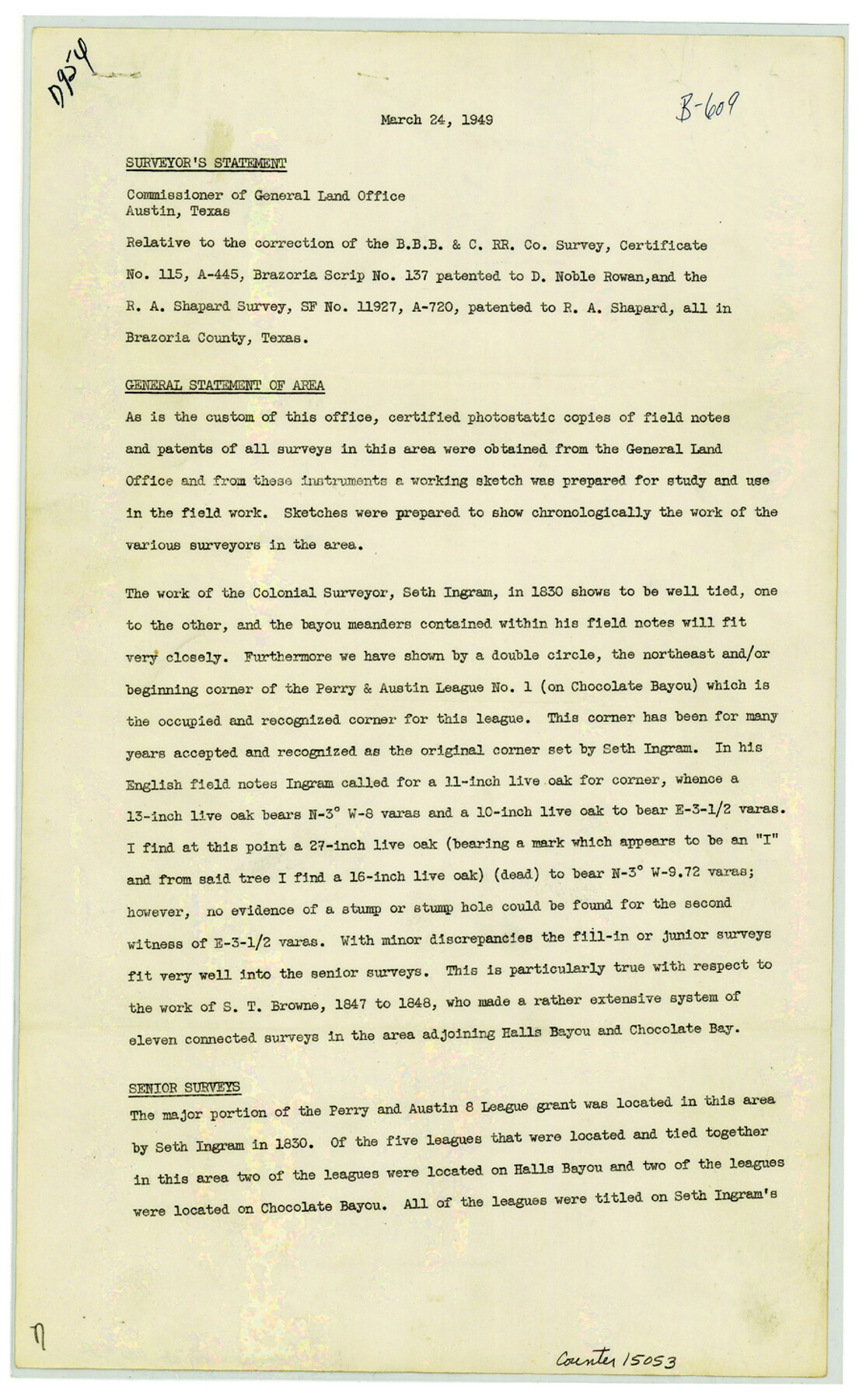
[Surveyor's statement in regard to correction of patents on B. B. B. & C. R.R. Co. and R.A. Shapard surveys in the southeast part of the county]
-
Map/Doc
15053
-
Collection
General Map Collection
-
Object Dates
1949/3/24 (Creation Date)
1949/5/6 (File Date)
-
People and Organizations
Adriance Munson (Surveyor/Engineer)
-
Counties
Brazoria
-
Subjects
Surveying Sketch File
-
Height x Width
14.7 x 9.0 inches
37.3 x 22.9 cm
-
Medium
paper, print
-
Comments
See Brazoria County Rolled Sketch 38 (8460) and Brazoria County Rolled Sketch 39 (5174) for sketches.
-
Features
Chocolate Bayou
Hall's Bayou
Little Salt Bayou
Mustang Bayou
New Bayou
West Bay
Related maps
Brazoria County Rolled Sketch 39

Print $20.00
- Digital $50.00
Brazoria County Rolled Sketch 39
1949
Size 22.8 x 34.8 inches
Map/Doc 5174
Brazoria County Rolled Sketch 38

Print $20.00
- Digital $50.00
Brazoria County Rolled Sketch 38
1949
Size 44.6 x 39.5 inches
Map/Doc 8460
Part of: General Map Collection
Reeves County Rolled Sketch 23

Print $20.00
- Digital $50.00
Reeves County Rolled Sketch 23
1982
Size 19.6 x 25.5 inches
Map/Doc 7491
St. L. S-W. Ry. of Texas Map of Lufkin Branch in Angelina County, Texas

Print $20.00
- Digital $50.00
St. L. S-W. Ry. of Texas Map of Lufkin Branch in Angelina County, Texas
1913
Size 24.0 x 12.1 inches
Map/Doc 64562
Webb County Sketch File 9

Print $25.00
- Digital $50.00
Webb County Sketch File 9
1870
Size 9.5 x 8.5 inches
Map/Doc 39761
Starr County Working Sketch 29

Print $20.00
- Digital $50.00
Starr County Working Sketch 29
2007
Size 28.6 x 34.0 inches
Map/Doc 87208
Harris County Working Sketch 17

Print $20.00
- Digital $50.00
Harris County Working Sketch 17
1919
Size 40.0 x 41.6 inches
Map/Doc 65909
Ector County Sketch File 8

Print $20.00
- Digital $50.00
Ector County Sketch File 8
1939
Size 40.9 x 24.9 inches
Map/Doc 10441
Hutchinson County Rolled Sketch 44-8

Print $20.00
- Digital $50.00
Hutchinson County Rolled Sketch 44-8
2002
Size 24.0 x 36.0 inches
Map/Doc 77544
Terrell County Boundary File 1

Print $12.00
- Digital $50.00
Terrell County Boundary File 1
Size 8.9 x 6.2 inches
Map/Doc 59196
Aransas County NRC Article 33.136 Sketch 22

Print $24.00
Aransas County NRC Article 33.136 Sketch 22
2023
Map/Doc 97270
Hardin County Working Sketch 37

Print $40.00
- Digital $50.00
Hardin County Working Sketch 37
1981
Size 68.5 x 37.4 inches
Map/Doc 63435
Ochiltree County Sketch File 8

Print $16.00
- Digital $50.00
Ochiltree County Sketch File 8
1933
Size 11.2 x 8.7 inches
Map/Doc 33186
Aransas County Aerial Photograph Index Sheet 1

Print $20.00
- Digital $50.00
Aransas County Aerial Photograph Index Sheet 1
1957
Size 22.9 x 18.2 inches
Map/Doc 83659
You may also like
Oldham County Boundary File 1b

Print $48.00
- Digital $50.00
Oldham County Boundary File 1b
Size 14.0 x 8.5 inches
Map/Doc 57747
Hudspeth County Rolled Sketch 58

Print $20.00
- Digital $50.00
Hudspeth County Rolled Sketch 58
Size 31.4 x 32.6 inches
Map/Doc 6258
Chart showing the positions of the lights in the Eighth L. H. District extending from the Perdido River, Florida to the Rio Grande, Texas

Print $20.00
- Digital $50.00
Chart showing the positions of the lights in the Eighth L. H. District extending from the Perdido River, Florida to the Rio Grande, Texas
1876
Size 24.7 x 18.2 inches
Map/Doc 72682


Kimble County

Print $40.00
- Digital $50.00
Kimble County
1890
Size 40.0 x 56.9 inches
Map/Doc 66891

Travis County Rolled Sketch 56

Print $20.00
- Digital $50.00
Travis County Rolled Sketch 56
1885
Size 16.7 x 23.2 inches
Map/Doc 8047
Hardin County Sketch File 8

Print $8.00
- Digital $50.00
Hardin County Sketch File 8
1870
Size 12.6 x 8.1 inches
Map/Doc 25102
A Topographical Map of the City of Austin

Print $20.00
- Digital $50.00
A Topographical Map of the City of Austin
1872
Size 20.6 x 15.1 inches
Map/Doc 93685
Flight Mission No. DQN-1K, Frame 122, Calhoun County

Print $20.00
- Digital $50.00
Flight Mission No. DQN-1K, Frame 122, Calhoun County
1953
Size 18.5 x 22.2 inches
Map/Doc 84188
