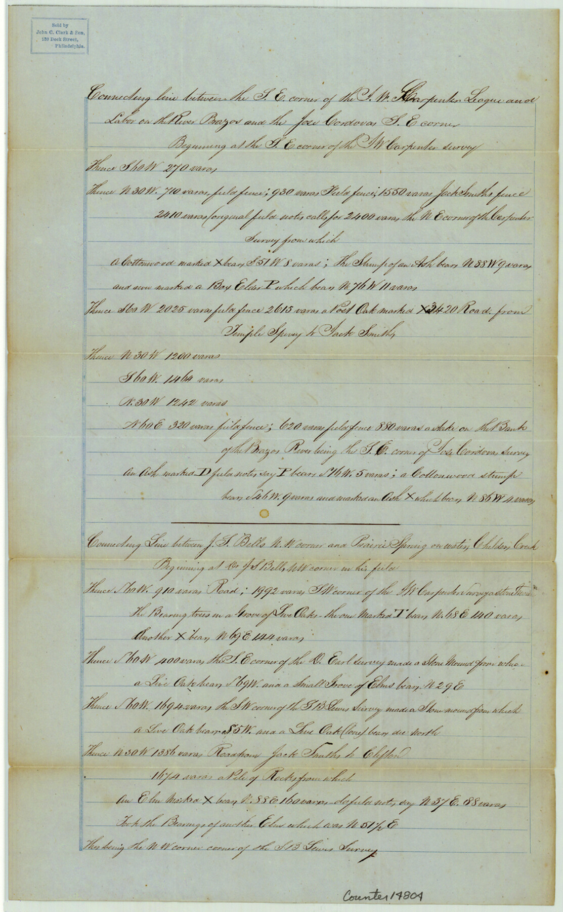
Bosque County Sketch File 22
[Field notes of connecting line between the southeast corner of the J.W. Carpenter league and labor on the Brazos River and the Jose Cordova southeast corner in the southeast corner of the county]
-
Map/Doc
14804
-
Collection
General Map Collection
-
Object Dates
1863/8/3 (Creation Date)
1863/8/13 (File Date)
-
People and Organizations
J. De Cordova (Surveyor/Engineer)
Henry M. De Cordova (Surveyor/Engineer)
-
Counties
Bosque
-
Subjects
Surveying Sketch File
-
Height x Width
13.8 x 8.5 inches
35.1 x 21.6 cm
-
Medium
paper, manuscript
-
Features
Brazos River
Childers Creek
Prairie Spring
Part of: General Map Collection
Fort Bend County Sketch File 2a

Print $4.00
- Digital $50.00
Fort Bend County Sketch File 2a
Size 12.7 x 8.1 inches
Map/Doc 22878
Atascosa County Working Sketch 12

Print $20.00
- Digital $50.00
Atascosa County Working Sketch 12
1926
Size 23.0 x 29.2 inches
Map/Doc 67208
Floyd County Boundary File 4a

Print $40.00
- Digital $50.00
Floyd County Boundary File 4a
Size 12.2 x 35.8 inches
Map/Doc 53496
Hansford County Sketch File 1

Print $7.00
- Digital $50.00
Hansford County Sketch File 1
1888
Size 39.0 x 31.3 inches
Map/Doc 10475
Hutchinson County Rolled Sketch 41

Print $40.00
- Digital $50.00
Hutchinson County Rolled Sketch 41
1989
Size 43.3 x 144.5 inches
Map/Doc 9249
Atascosa County Working Sketch 17

Print $20.00
- Digital $50.00
Atascosa County Working Sketch 17
1945
Size 25.6 x 29.9 inches
Map/Doc 67213
Matagorda County Sketch File 33

Print $6.00
- Digital $50.00
Matagorda County Sketch File 33
1938
Size 14.2 x 8.8 inches
Map/Doc 30817
Matagorda County

Print $40.00
- Digital $50.00
Matagorda County
1920
Size 40.6 x 48.6 inches
Map/Doc 73232
Dawson County Rolled Sketch 13

Print $20.00
- Digital $50.00
Dawson County Rolled Sketch 13
1951
Size 18.9 x 25.4 inches
Map/Doc 5696
Flight Mission No. BRA-7M, Frame 183, Jefferson County

Print $20.00
- Digital $50.00
Flight Mission No. BRA-7M, Frame 183, Jefferson County
1953
Size 18.6 x 22.3 inches
Map/Doc 85551
Ellis County Sketch File 19

Print $6.00
- Digital $50.00
Ellis County Sketch File 19
1863
Size 12.4 x 7.8 inches
Map/Doc 21866
Sutton County Rolled Sketch 68

Print $20.00
- Digital $50.00
Sutton County Rolled Sketch 68
Size 31.0 x 37.4 inches
Map/Doc 9980
You may also like
Cottle County Sketch File 4

Print $16.00
- Digital $50.00
Cottle County Sketch File 4
Size 8.2 x 4.2 inches
Map/Doc 19466
Trinity County Sketch File 34A

Print $6.00
- Digital $50.00
Trinity County Sketch File 34A
1921
Size 16.6 x 10.8 inches
Map/Doc 38578
Chambers County Boundary File 4

Print $34.00
- Digital $50.00
Chambers County Boundary File 4
1909
Size 9.1 x 3.9 inches
Map/Doc 51259
Coast Chart No. 210 Aransas Pass and Corpus Christi Bay with the coast to latitude 27° 12' Texas

Print $20.00
- Digital $50.00
Coast Chart No. 210 Aransas Pass and Corpus Christi Bay with the coast to latitude 27° 12' Texas
1887
Size 27.3 x 18.2 inches
Map/Doc 72792
Eastland County Working Sketch 66

Print $20.00
- Digital $50.00
Eastland County Working Sketch 66
2014
Size 27.2 x 20.1 inches
Map/Doc 93708
Right of Way and Track Map Houston & Texas Central R.R. operated by the T. and N. O. R.R. Co., Fort Worth Branch

Print $40.00
- Digital $50.00
Right of Way and Track Map Houston & Texas Central R.R. operated by the T. and N. O. R.R. Co., Fort Worth Branch
1918
Size 31.1 x 57.4 inches
Map/Doc 64540
Wichita County Working Sketch 12b

Print $20.00
- Digital $50.00
Wichita County Working Sketch 12b
1920
Size 21.2 x 14.9 inches
Map/Doc 72522
Dickens County Sketch File 5

Print $40.00
- Digital $50.00
Dickens County Sketch File 5
Size 24.3 x 18.1 inches
Map/Doc 75996
A Correct Map of the Seat of War in Mexico

Print $20.00
A Correct Map of the Seat of War in Mexico
1847
Size 28.3 x 21.1 inches
Map/Doc 79725
Zapata County Working Sketch 18

Print $20.00
- Digital $50.00
Zapata County Working Sketch 18
1975
Size 43.2 x 29.1 inches
Map/Doc 62069
[Surveys just south of Runnels County School Land Survey No. 3]
![91552, [Surveys just south of Runnels County School Land Survey No. 3], Twichell Survey Records](https://historictexasmaps.com/wmedia_w700/maps/91552-1.tif.jpg)
Print $20.00
- Digital $50.00
[Surveys just south of Runnels County School Land Survey No. 3]
1926
Size 19.4 x 13.1 inches
Map/Doc 91552
Oldham County Boundary File 1a

Print $62.00
- Digital $50.00
Oldham County Boundary File 1a
Size 13.0 x 8.1 inches
Map/Doc 57734