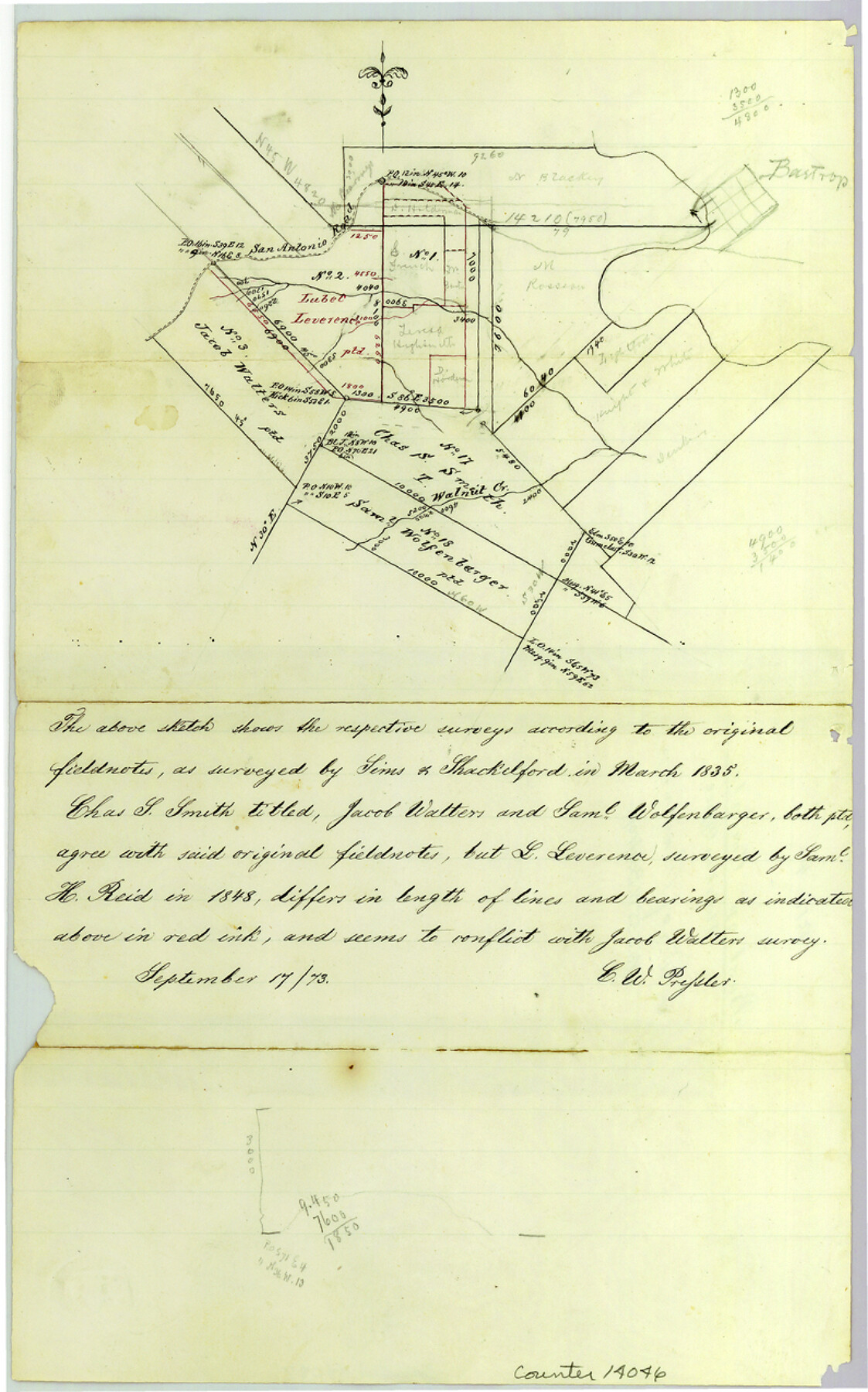
Bastrop County Sketch File 4
[Office sketch of area southwest of Bastrop]
-
Map/Doc
14046
-
Collection
General Map Collection
-
Object Dates
9/17/1873 (Creation Date)
-
People and Organizations
Chas. W. Pressler (Compiler)
-
Counties
Bastrop
-
Subjects
Surveying Sketch File
-
Height x Width
12.7 x 7.9 inches
32.3 x 20.1 cm
-
Medium
paper, manuscript
-
Features
San Antonio Road
Bastrop
Walnut Creek
Part of: General Map Collection
Working Sketch, Goliad & Bee Counties

Print $20.00
- Digital $50.00
Working Sketch, Goliad & Bee Counties
1936
Size 35.0 x 43.1 inches
Map/Doc 2453
Flight Mission No. DAG-24K, Frame 42, Matagorda County

Print $20.00
- Digital $50.00
Flight Mission No. DAG-24K, Frame 42, Matagorda County
1953
Size 18.5 x 22.3 inches
Map/Doc 86529
Trinity River, Dallas Elevation Sheet

Print $20.00
- Digital $50.00
Trinity River, Dallas Elevation Sheet
1913
Size 26.6 x 24.1 inches
Map/Doc 65258
Nueces County Working Sketch 1

Print $20.00
- Digital $50.00
Nueces County Working Sketch 1
1937
Size 27.9 x 28.5 inches
Map/Doc 71303
Duval County Rolled Sketch 22

Print $20.00
- Digital $50.00
Duval County Rolled Sketch 22
1942
Size 19.5 x 30.0 inches
Map/Doc 5741
Coast of Texas Between Brazos River and Matagorda Bay

Print $40.00
- Digital $50.00
Coast of Texas Between Brazos River and Matagorda Bay
1853
Size 32.6 x 72.1 inches
Map/Doc 69977
Current Miscellaneous File 80

Print $8.00
- Digital $50.00
Current Miscellaneous File 80
Size 13.7 x 8.7 inches
Map/Doc 74213
Jeff Davis County Working Sketch 27

Print $20.00
- Digital $50.00
Jeff Davis County Working Sketch 27
1960
Size 18.1 x 24.3 inches
Map/Doc 66522
Armstrong County Working Sketch 4

Print $20.00
- Digital $50.00
Armstrong County Working Sketch 4
1918
Size 23.9 x 32.0 inches
Map/Doc 67235
Duval County Sketch File 67

Print $16.00
- Digital $50.00
Duval County Sketch File 67
1949
Size 14.2 x 8.8 inches
Map/Doc 21448

Presidio County Working Sketch 112

Print $20.00
- Digital $50.00
Presidio County Working Sketch 112
1979
Size 41.7 x 35.6 inches
Map/Doc 71789
You may also like
Hopkins County

Print $20.00
- Digital $50.00
Hopkins County
1942
Size 43.6 x 41.6 inches
Map/Doc 1858
Tom Green County Sketch File 16

Print $16.00
- Digital $50.00
Tom Green County Sketch File 16
Size 8.5 x 7.8 inches
Map/Doc 38174
Right of Way & Track Map, St. Louis, Brownsville & Mexico Ry. operated by St. Louis, Brownsville & Mexico Ry. Co.

Print $40.00
- Digital $50.00
Right of Way & Track Map, St. Louis, Brownsville & Mexico Ry. operated by St. Louis, Brownsville & Mexico Ry. Co.
1919
Size 25.5 x 57.1 inches
Map/Doc 64624
[Area around R. H. Hibbett and Geo. W. Lawrence surveys on Elm Fork of the Brazos River]
![90861, [Area around R. H. Hibbett and Geo. W. Lawrence surveys on Elm Fork of the Brazos River], Twichell Survey Records](https://historictexasmaps.com/wmedia_w700/maps/90861-2.tif.jpg)
Print $20.00
- Digital $50.00
[Area around R. H. Hibbett and Geo. W. Lawrence surveys on Elm Fork of the Brazos River]
1901
Size 23.6 x 32.4 inches
Map/Doc 90861
Hood County Working Sketch 12

Print $40.00
- Digital $50.00
Hood County Working Sketch 12
1978
Size 25.2 x 55.5 inches
Map/Doc 66206
Polk County Sketch File 24

Print $20.00
- Digital $50.00
Polk County Sketch File 24
Size 14.3 x 30.8 inches
Map/Doc 12193
Right of Way & Track Map, San Antonio & Aransas Pass Railway Co.

Print $40.00
- Digital $50.00
Right of Way & Track Map, San Antonio & Aransas Pass Railway Co.
1919
Size 25.3 x 56.7 inches
Map/Doc 64216
Culberson County Rolled Sketch 52

Print $20.00
- Digital $50.00
Culberson County Rolled Sketch 52
1966
Size 19.1 x 24.9 inches
Map/Doc 5671
Polk County Boundary File 1

Print $24.00
- Digital $50.00
Polk County Boundary File 1
Size 12.6 x 8.0 inches
Map/Doc 57912
Karnes County Sketch File 12

Print $14.00
- Digital $50.00
Karnes County Sketch File 12
1889
Size 12.7 x 8.0 inches
Map/Doc 28604
Bird's Eye View of Brenham, Washington County, Texas

Print $20.00
Bird's Eye View of Brenham, Washington County, Texas
1873
Size 20.0 x 25.7 inches
Map/Doc 89075
Hutchinson County Sketch File 52

Print $14.00
- Digital $50.00
Hutchinson County Sketch File 52
1992
Size 14.2 x 8.8 inches
Map/Doc 27449