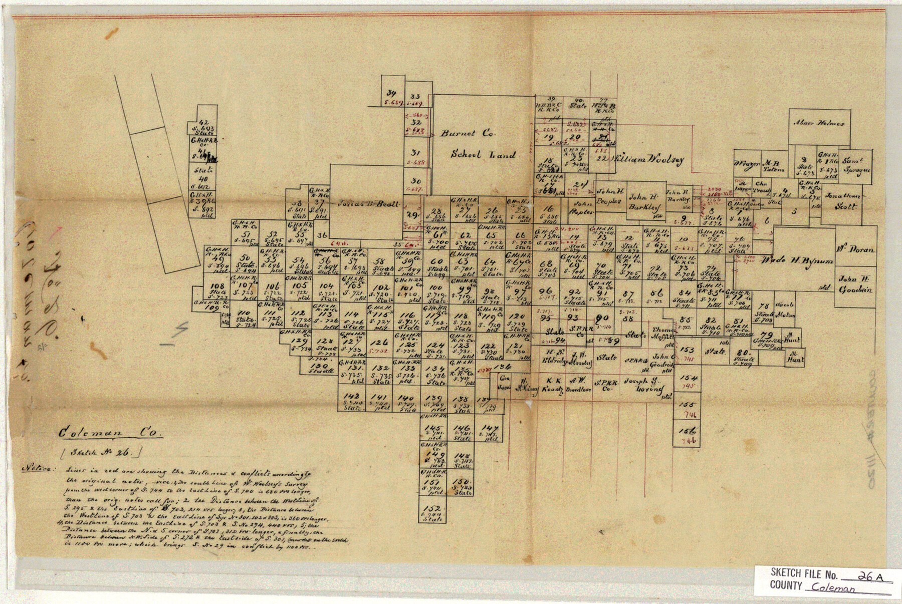
Coleman County Sketch File 26a
[Sketch of large area in southwest quadrant of the county and extending into Runnels County]
-
Map/Doc
11120
-
Collection
General Map Collection
-
Counties
Coleman Runnels
-
Subjects
Surveying Sketch File
-
Height x Width
10.6 x 15.8 inches
26.9 x 40.1 cm
-
Medium
paper, manuscript
Part of: General Map Collection
Somervell County

Print $20.00
- Digital $50.00
Somervell County
1884
Size 25.1 x 24.2 inches
Map/Doc 4042
San Augustine County Working Sketch 13

Print $20.00
- Digital $50.00
San Augustine County Working Sketch 13
1952
Size 34.0 x 27.6 inches
Map/Doc 63701
Northern Part of Laguna Madre

Print $20.00
- Digital $50.00
Northern Part of Laguna Madre
1982
Size 44.2 x 35.0 inches
Map/Doc 73530
Denton County

Print $20.00
- Digital $50.00
Denton County
1947
Size 43.4 x 39.9 inches
Map/Doc 95480
Walker County Working Sketch 19

Print $3.00
- Digital $50.00
Walker County Working Sketch 19
Size 9.3 x 16.1 inches
Map/Doc 72299
Stonewall County Working Sketch 27

Print $20.00
- Digital $50.00
Stonewall County Working Sketch 27
1976
Size 20.7 x 29.9 inches
Map/Doc 62334
Matagorda County NRC Article 33.136 Sketch 22

Print $24.00
Matagorda County NRC Article 33.136 Sketch 22
2025
Map/Doc 97486
Calcasieu Pass to Sabine Pass

Print $20.00
- Digital $50.00
Calcasieu Pass to Sabine Pass
1992
Size 44.5 x 35.8 inches
Map/Doc 69815
Edwards County Boundary File 27 1/2a

Print $56.00
- Digital $50.00
Edwards County Boundary File 27 1/2a
Size 14.1 x 8.8 inches
Map/Doc 52922
Rockwall County Boundary File 52a

Print $22.00
- Digital $50.00
Rockwall County Boundary File 52a
Size 12.9 x 8.3 inches
Map/Doc 58461
Polk County Sketch File 9

Print $28.00
- Digital $50.00
Polk County Sketch File 9
1861
Size 11.9 x 7.7 inches
Map/Doc 34136

You may also like

Runnels County Working Sketch 3

Print $20.00
- Digital $50.00
Runnels County Working Sketch 3
1888
Size 22.1 x 20.3 inches
Map/Doc 63599
Coke County Sketch File 8

Print $20.00
- Digital $50.00
Coke County Sketch File 8
Size 20.2 x 27.8 inches
Map/Doc 11106
Map of Asylum Lands

Print $20.00
- Digital $50.00
Map of Asylum Lands
1857
Size 22.0 x 29.1 inches
Map/Doc 2214
Map of Texas and the countries adjacent compiled in the Bureau of the Corps of Topographical Engineers from the best authorities for the State Department

Print $20.00
- Digital $50.00
Map of Texas and the countries adjacent compiled in the Bureau of the Corps of Topographical Engineers from the best authorities for the State Department
1844
Size 25.9 x 18.2 inches
Map/Doc 72714
Edwards County Working Sketch 67

Print $20.00
- Digital $50.00
Edwards County Working Sketch 67
1957
Size 38.3 x 44.2 inches
Map/Doc 68943
Anderson County Working Sketch 2

Print $20.00
- Digital $50.00
Anderson County Working Sketch 2
Size 31.8 x 37.7 inches
Map/Doc 67001
The Republic County of Brazoria. Proposed, Late Fall 1837-January 1, 1838

Print $20.00
The Republic County of Brazoria. Proposed, Late Fall 1837-January 1, 1838
2020
Size 13.0 x 21.7 inches
Map/Doc 96110
Jefferson County Rolled Sketch 8A

Print $20.00
- Digital $50.00
Jefferson County Rolled Sketch 8A
1928
Size 35.6 x 46.3 inches
Map/Doc 76030
Liberty County Working Sketch 55

Print $20.00
- Digital $50.00
Liberty County Working Sketch 55
1962
Size 30.4 x 31.4 inches
Map/Doc 70515
Jackson County Rolled Sketch 8

Print $20.00
- Digital $50.00
Jackson County Rolled Sketch 8
1938
Size 28.6 x 28.1 inches
Map/Doc 6343
The Mexican Municipality of Harrisburg. Defined, January 4, 1836

Print $20.00
The Mexican Municipality of Harrisburg. Defined, January 4, 1836
2020
Size 18.4 x 21.7 inches
Map/Doc 96022