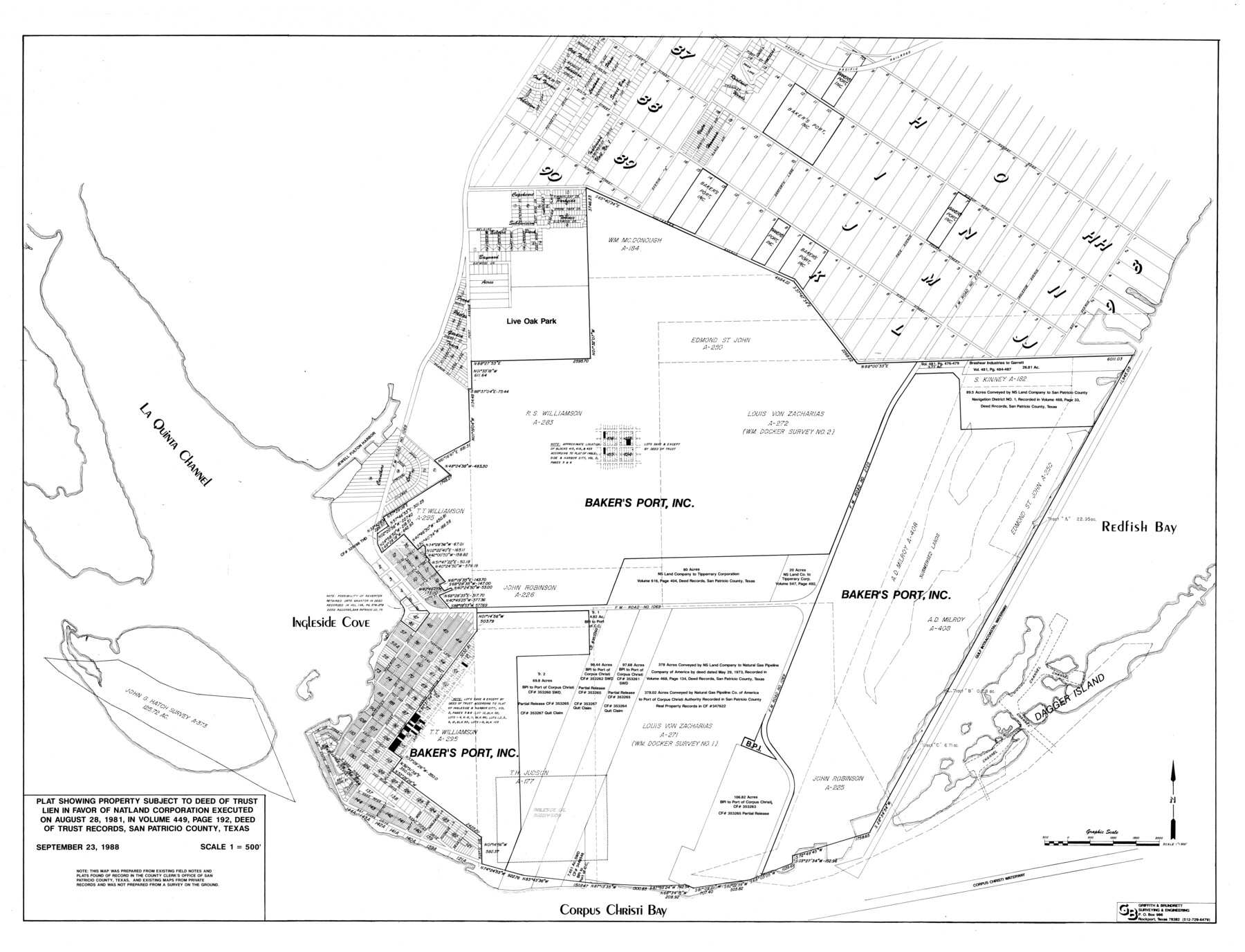
San Patricio County Rolled Sketch 51
Plat showing property subject to Deed of Trust lien in favor of Natland Corporation
-
Map/Doc
10635
-
Collection
General Map Collection
-
Object Dates
1988/9/23 (Creation Date)
1989/5/5 (File Date)
-
Counties
San Patricio
-
Subjects
Surveying Rolled Sketch
-
Height x Width
41.8 x 54.6 inches
106.2 x 138.7 cm
-
Scale
1" = 500 feet
Part of: General Map Collection
Trinity County

Print $20.00
- Digital $50.00
Trinity County
1946
Size 40.5 x 40.7 inches
Map/Doc 77440
Presidio County Working Sketch 127

Print $20.00
- Digital $50.00
Presidio County Working Sketch 127
1987
Size 42.8 x 29.5 inches
Map/Doc 71805
Shelby County Working Sketch 33

Print $20.00
- Digital $50.00
Shelby County Working Sketch 33
2008
Size 23.6 x 27.5 inches
Map/Doc 88886
Leon County Working Sketch 27

Print $20.00
- Digital $50.00
Leon County Working Sketch 27
1970
Size 22.4 x 24.4 inches
Map/Doc 70426
Sketch of surveys on Deer Creek, Milam District

Print $2.00
- Digital $50.00
Sketch of surveys on Deer Creek, Milam District
1846
Size 7.8 x 10.9 inches
Map/Doc 76046
Red River County Sketch File 28

Print $22.00
- Digital $50.00
Red River County Sketch File 28
1995
Size 11.3 x 8.9 inches
Map/Doc 35165
[Maps of surveys in Reeves & Culberson Cos]
![61139, [Maps of surveys in Reeves & Culberson Cos], General Map Collection](https://historictexasmaps.com/wmedia_w700/maps/61139.tif.jpg)
Print $20.00
- Digital $50.00
[Maps of surveys in Reeves & Culberson Cos]
1937
Size 30.7 x 24.7 inches
Map/Doc 61139
Jasper County Working Sketch 24

Print $40.00
- Digital $50.00
Jasper County Working Sketch 24
1948
Size 46.9 x 56.2 inches
Map/Doc 66486
Jefferson County NRC Article 33.136 Sketch 4

Print $2.00
- Digital $50.00
Jefferson County NRC Article 33.136 Sketch 4
2004
Size 14.5 x 8.4 inches
Map/Doc 82993
Hockley County

Print $20.00
- Digital $50.00
Hockley County
1897
Size 19.1 x 20.5 inches
Map/Doc 3675
Montgomery County Sketch File 31

Print $20.00
- Digital $50.00
Montgomery County Sketch File 31
1932
Size 35.2 x 34.1 inches
Map/Doc 10550
Taylor County Sketch File 14

Print $6.00
- Digital $50.00
Taylor County Sketch File 14
1881
Size 12.9 x 8.5 inches
Map/Doc 37802
You may also like
Bowie County Working Sketch 27

Print $20.00
- Digital $50.00
Bowie County Working Sketch 27
1987
Size 39.1 x 33.8 inches
Map/Doc 67431
Irion County Rolled Sketch 9

Print $20.00
- Digital $50.00
Irion County Rolled Sketch 9
1940
Size 31.9 x 30.6 inches
Map/Doc 6321
Taylor County Working Sketch 14

Print $20.00
- Digital $50.00
Taylor County Working Sketch 14
1959
Size 26.8 x 21.4 inches
Map/Doc 69624
Reagan County Working Sketch 22

Print $20.00
- Digital $50.00
Reagan County Working Sketch 22
1955
Size 24.2 x 24.4 inches
Map/Doc 71864
Sketch of part of Brazos Island

Print $20.00
- Digital $50.00
Sketch of part of Brazos Island
1863
Size 25.1 x 18.2 inches
Map/Doc 72923
J. B. McCauley Irrigated Farm SW Quarter Section 20, Block E

Print $20.00
- Digital $50.00
J. B. McCauley Irrigated Farm SW Quarter Section 20, Block E
1944
Size 20.7 x 23.5 inches
Map/Doc 92335
Childress County Sketch File 7

Print $20.00
- Digital $50.00
Childress County Sketch File 7
Size 14.9 x 17.6 inches
Map/Doc 11079
[Gulf, Colorado & Santa Fe Railway Company]
![64410, [Gulf, Colorado & Santa Fe Railway Company], General Map Collection](https://historictexasmaps.com/wmedia_w700/maps/64410.tif.jpg)
Print $40.00
- Digital $50.00
[Gulf, Colorado & Santa Fe Railway Company]
1893
Size 21.5 x 121.2 inches
Map/Doc 64410
[Map to illustrate possible mineral resources on the lands belonging to the University of Texas]
![62963, [Map to illustrate possible mineral resources on the lands belonging to the University of Texas], General Map Collection](https://historictexasmaps.com/wmedia_w700/maps/62963.tif.jpg)
Print $2.00
- Digital $50.00
[Map to illustrate possible mineral resources on the lands belonging to the University of Texas]
Size 10.2 x 7.7 inches
Map/Doc 62963
[Southeast part of County near Jas. H. Price Survey]
![91915, [Southeast part of County near Jas. H. Price Survey], Twichell Survey Records](https://historictexasmaps.com/wmedia_w700/maps/91915-1.tif.jpg)
Print $20.00
- Digital $50.00
[Southeast part of County near Jas. H. Price Survey]
Size 19.9 x 20.0 inches
Map/Doc 91915
Briscoe County Sketch File O-1

Print $2.00
- Digital $50.00
Briscoe County Sketch File O-1
1935
Size 11.3 x 7.2 inches
Map/Doc 16425
Harris County Sketch File 93

Print $20.00
- Digital $50.00
Harris County Sketch File 93
1952
Size 33.0 x 14.5 inches
Map/Doc 11676