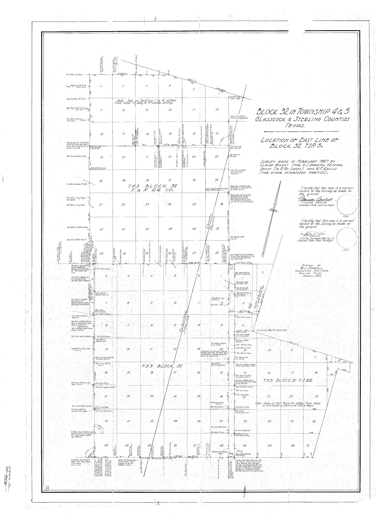
Sterling County Sketch File 17a
Block 32 in Township 4 & 5 Glasscock & Sterling Counties Texas; Location of East Line of Block 32, Tsp. 5
-
Map/Doc
10609
-
Collection
General Map Collection
-
Object Dates
2/1927 (Survey Date)
-
People and Organizations
Claude Becket (Surveyor/Engineer)
-
Counties
Sterling Glasscock
-
Subjects
Surveying Sketch File
-
Height x Width
42.8 x 31.6 inches
108.7 x 80.3 cm
-
Medium
paper, print
-
Features
Lacy Creek
Garden City Road
Part of: General Map Collection
Map of Llano County

Print $20.00
- Digital $50.00
Map of Llano County
1859
Size 28.6 x 21.7 inches
Map/Doc 3826
Wichita County Sketch File 26

Print $20.00
- Digital $50.00
Wichita County Sketch File 26
1919
Size 24.9 x 36.6 inches
Map/Doc 12686
Flight Mission No. DIX-5P, Frame 106, Aransas County

Print $20.00
- Digital $50.00
Flight Mission No. DIX-5P, Frame 106, Aransas County
1956
Size 17.8 x 18.0 inches
Map/Doc 83784
[San Antonio & Aransas Pass]
![64209, [San Antonio & Aransas Pass], General Map Collection](https://historictexasmaps.com/wmedia_w700/maps/64209.tif.jpg)
Print $20.00
- Digital $50.00
[San Antonio & Aransas Pass]
Size 15.2 x 45.5 inches
Map/Doc 64209
Cottle County Working Sketch 2

Print $3.00
- Digital $50.00
Cottle County Working Sketch 2
1902
Size 9.9 x 13.2 inches
Map/Doc 68312
Origins of Exports and Destination of Imports at Houston during 1921

Print $20.00
- Digital $50.00
Origins of Exports and Destination of Imports at Houston during 1921
1921
Size 13.6 x 19.6 inches
Map/Doc 97170
Flight Mission No. DIX-8P, Frame 88, Aransas County

Print $20.00
- Digital $50.00
Flight Mission No. DIX-8P, Frame 88, Aransas County
1956
Size 18.6 x 22.3 inches
Map/Doc 83913
Burnet County Boundary File 12a

Print $8.00
- Digital $50.00
Burnet County Boundary File 12a
Size 12.9 x 8.7 inches
Map/Doc 50956
Intracoastal Waterway in Texas - Corpus Christi to Point Isabel including Arroyo Colorado to Mo. Pac. R.R. Bridge Near Harlingen

Print $20.00
- Digital $50.00
Intracoastal Waterway in Texas - Corpus Christi to Point Isabel including Arroyo Colorado to Mo. Pac. R.R. Bridge Near Harlingen
1933
Size 28.2 x 41.0 inches
Map/Doc 61846
Map of Houston Heights, Harris County, Texas owned by the Omaha & South Texas Land Co., Houston, Texas

Print $20.00
- Digital $50.00
Map of Houston Heights, Harris County, Texas owned by the Omaha & South Texas Land Co., Houston, Texas
1891
Size 16.3 x 10.7 inches
Map/Doc 94458
El Paso County Working Sketch 11

Print $40.00
- Digital $50.00
El Paso County Working Sketch 11
1955
Size 49.2 x 43.4 inches
Map/Doc 69033
Marion County Working Sketch 11

Print $20.00
- Digital $50.00
Marion County Working Sketch 11
1952
Size 23.8 x 28.7 inches
Map/Doc 70786
You may also like
Outer Continental Shelf Leasing Maps (Louisiana Offshore Operations)

Print $20.00
- Digital $50.00
Outer Continental Shelf Leasing Maps (Louisiana Offshore Operations)
1955
Size 17.2 x 9.4 inches
Map/Doc 76081
Haskell County Sketch File 16

Print $32.00
- Digital $50.00
Haskell County Sketch File 16
1894
Size 11.2 x 8.8 inches
Map/Doc 26163

El Paso County Sketch File 22a

Print $52.00
- Digital $50.00
El Paso County Sketch File 22a
1888
Size 14.2 x 8.7 inches
Map/Doc 22042
Comanche County Sketch File 23

Print $4.00
- Digital $50.00
Comanche County Sketch File 23
Size 8.3 x 7.5 inches
Map/Doc 19111
Flight Mission No. DAG-24K, Frame 131, Matagorda County

Print $20.00
- Digital $50.00
Flight Mission No. DAG-24K, Frame 131, Matagorda County
1953
Size 18.6 x 22.4 inches
Map/Doc 86549
Brewster County Rolled Sketch 21

Print $20.00
- Digital $50.00
Brewster County Rolled Sketch 21
1907
Size 28.5 x 26.0 inches
Map/Doc 5200
Trinity County Sketch File 27

Print $4.00
- Digital $50.00
Trinity County Sketch File 27
Size 12.0 x 8.6 inches
Map/Doc 38562
Bee County Sketch File 20

Print $8.00
- Digital $50.00
Bee County Sketch File 20
1861
Size 14.3 x 8.8 inches
Map/Doc 14308
Menard County Sketch File 7

Print $4.00
- Digital $50.00
Menard County Sketch File 7
Size 5.8 x 12.0 inches
Map/Doc 31492
Jasper County Working Sketch 10

Print $20.00
- Digital $50.00
Jasper County Working Sketch 10
1917
Size 17.4 x 22.7 inches
Map/Doc 66472
Sketch of work done by Erath and Green in August 1846 on the north fork of Cow Bayou

Print $2.00
- Digital $50.00
Sketch of work done by Erath and Green in August 1846 on the north fork of Cow Bayou
1846
Size 9.8 x 7.9 inches
Map/Doc 78373