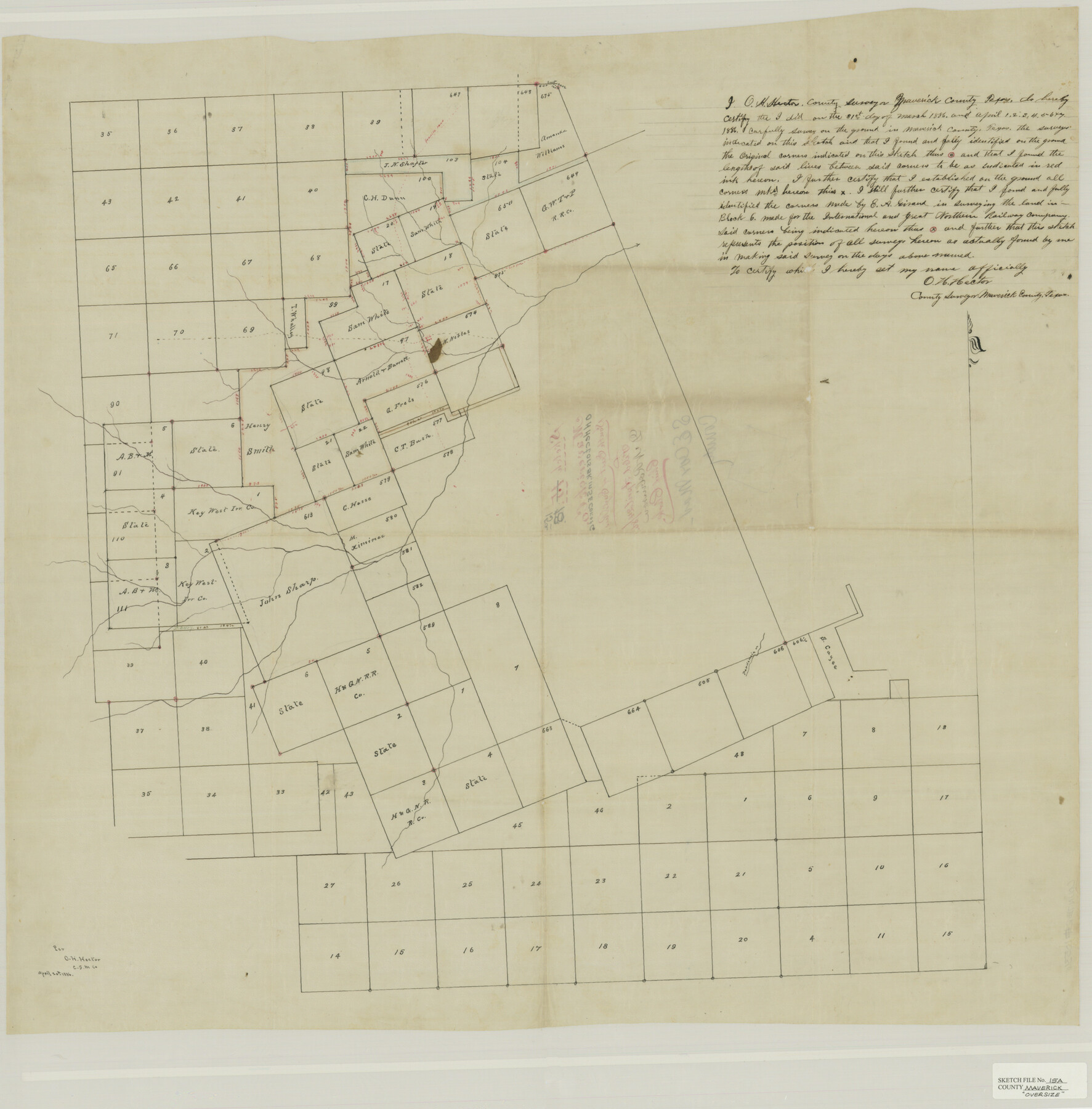
Maverick County Sketch File 15a
[Sketch of area in the east part of the county near the boundary with Dimmit and Zavala Counties]
-
Map/Doc
10536
-
Collection
General Map Collection
-
Object Dates
4/20/1886 (Creation Date)
4/24/1886 (File Date)
-
People and Organizations
O.H. Hector (Surveyor/Engineer)
-
Counties
Maverick Dimmit Zavala
-
Subjects
Surveying Sketch File
-
Height x Width
30.8 x 30.3 inches
78.2 x 77.0 cm
-
Medium
paper, manuscript
-
Features
Frenita Road
Perdernia Creek
Part of: General Map Collection
Bailey County Sketch File 14

Print $4.00
- Digital $50.00
Bailey County Sketch File 14
Size 12.2 x 8.7 inches
Map/Doc 13973

Texas and Mexico showing Houston and Texas Central System of Railways

Print $20.00
- Digital $50.00
Texas and Mexico showing Houston and Texas Central System of Railways
Size 29.0 x 21.6 inches
Map/Doc 94274
Wichita County Sketch File 3

Print $8.00
- Digital $50.00
Wichita County Sketch File 3
1856
Size 7.2 x 16.3 inches
Map/Doc 40033
[Map showing the location of the Pecos Valley Railway through H. &. G. N. R.R. Co. Land in Reeves Co., Texas]
![64707, [Map showing the location of the Pecos Valley Railway through H. &. G. N. R.R. Co. Land in Reeves Co., Texas], General Map Collection](https://historictexasmaps.com/wmedia_w700/maps/64707.tif.jpg)
Print $40.00
- Digital $50.00
[Map showing the location of the Pecos Valley Railway through H. &. G. N. R.R. Co. Land in Reeves Co., Texas]
1891
Size 39.1 x 123.6 inches
Map/Doc 64707
J No. 5 - Reconnaissance of San Clemente Harbor, California / Reconnaissance of Prisoner's Harbor, California / Reconnaissance of Cuyler's Harbor, Island of San Miguel, California

Print $20.00
- Digital $50.00
J No. 5 - Reconnaissance of San Clemente Harbor, California / Reconnaissance of Prisoner's Harbor, California / Reconnaissance of Cuyler's Harbor, Island of San Miguel, California
1852
Size 19.2 x 16.5 inches
Map/Doc 97234
Flight Mission No. DCL-6C, Frame 20, Kenedy County

Print $20.00
- Digital $50.00
Flight Mission No. DCL-6C, Frame 20, Kenedy County
1943
Size 18.7 x 22.4 inches
Map/Doc 85877
Armstrong County Boundary File 1c

Print $10.00
- Digital $50.00
Armstrong County Boundary File 1c
Size 14.1 x 8.7 inches
Map/Doc 50132
Liberty County Rolled Sketch O

Print $40.00
- Digital $50.00
Liberty County Rolled Sketch O
1954
Size 52.3 x 42.8 inches
Map/Doc 10720
Flight Mission No. CRC-3R, Frame 55, Chambers County

Print $20.00
- Digital $50.00
Flight Mission No. CRC-3R, Frame 55, Chambers County
1956
Size 18.6 x 22.4 inches
Map/Doc 84827
City of Corpus Christi, Texas

Print $20.00
- Digital $50.00
City of Corpus Christi, Texas
1969
Size 22.6 x 51.0 inches
Map/Doc 96520
Crosby County Boundary File 2

Print $64.00
- Digital $50.00
Crosby County Boundary File 2
Size 42.8 x 7.0 inches
Map/Doc 51997
You may also like
United States - Gulf Coast - From Latitude 26° 33' to the Rio Grande Texas

Print $20.00
- Digital $50.00
United States - Gulf Coast - From Latitude 26° 33' to the Rio Grande Texas
1913
Size 27.9 x 18.2 inches
Map/Doc 72832
Potter County Working Sketch 1

Print $20.00
- Digital $50.00
Potter County Working Sketch 1
Size 16.3 x 17.2 inches
Map/Doc 71661
Guadalupe County Working Sketch 4

Print $20.00
- Digital $50.00
Guadalupe County Working Sketch 4
1939
Size 17.7 x 10.8 inches
Map/Doc 63313
[Surveys near the Medina River, Bexar District]
![230, [Surveys near the Medina River, Bexar District], General Map Collection](https://historictexasmaps.com/wmedia_w700/maps/230.tif.jpg)
Print $2.00
- Digital $50.00
[Surveys near the Medina River, Bexar District]
1847
Size 13.1 x 8.0 inches
Map/Doc 230
Wichita County Working Sketch 26

Print $20.00
- Digital $50.00
Wichita County Working Sketch 26
1981
Size 13.1 x 21.0 inches
Map/Doc 72536
Presidio County Working Sketch 66

Print $20.00
- Digital $50.00
Presidio County Working Sketch 66
1960
Size 44.9 x 22.8 inches
Map/Doc 71743
Coleman County Sketch File 44

Print $17.00
- Digital $50.00
Coleman County Sketch File 44
Size 14.1 x 8.6 inches
Map/Doc 18783
Val Verde County Rolled Sketch 45

Print $20.00
- Digital $50.00
Val Verde County Rolled Sketch 45
Size 20.8 x 23.1 inches
Map/Doc 8118
Flight Mission No. BRA-7M, Frame 144, Jefferson County

Print $20.00
- Digital $50.00
Flight Mission No. BRA-7M, Frame 144, Jefferson County
1953
Size 18.5 x 22.3 inches
Map/Doc 85538
Kleberg County Boundary File 2a

Print $40.00
- Digital $50.00
Kleberg County Boundary File 2a
Size 15.4 x 58.3 inches
Map/Doc 64977
Hudspeth County Sketch File 52

Print $100.00
- Digital $50.00
Hudspeth County Sketch File 52
1983
Size 10.9 x 31.2 inches
Map/Doc 11807
Colorado County Working Sketch 8

Print $20.00
- Digital $50.00
Colorado County Working Sketch 8
1937
Size 19.7 x 21.0 inches
Map/Doc 68108