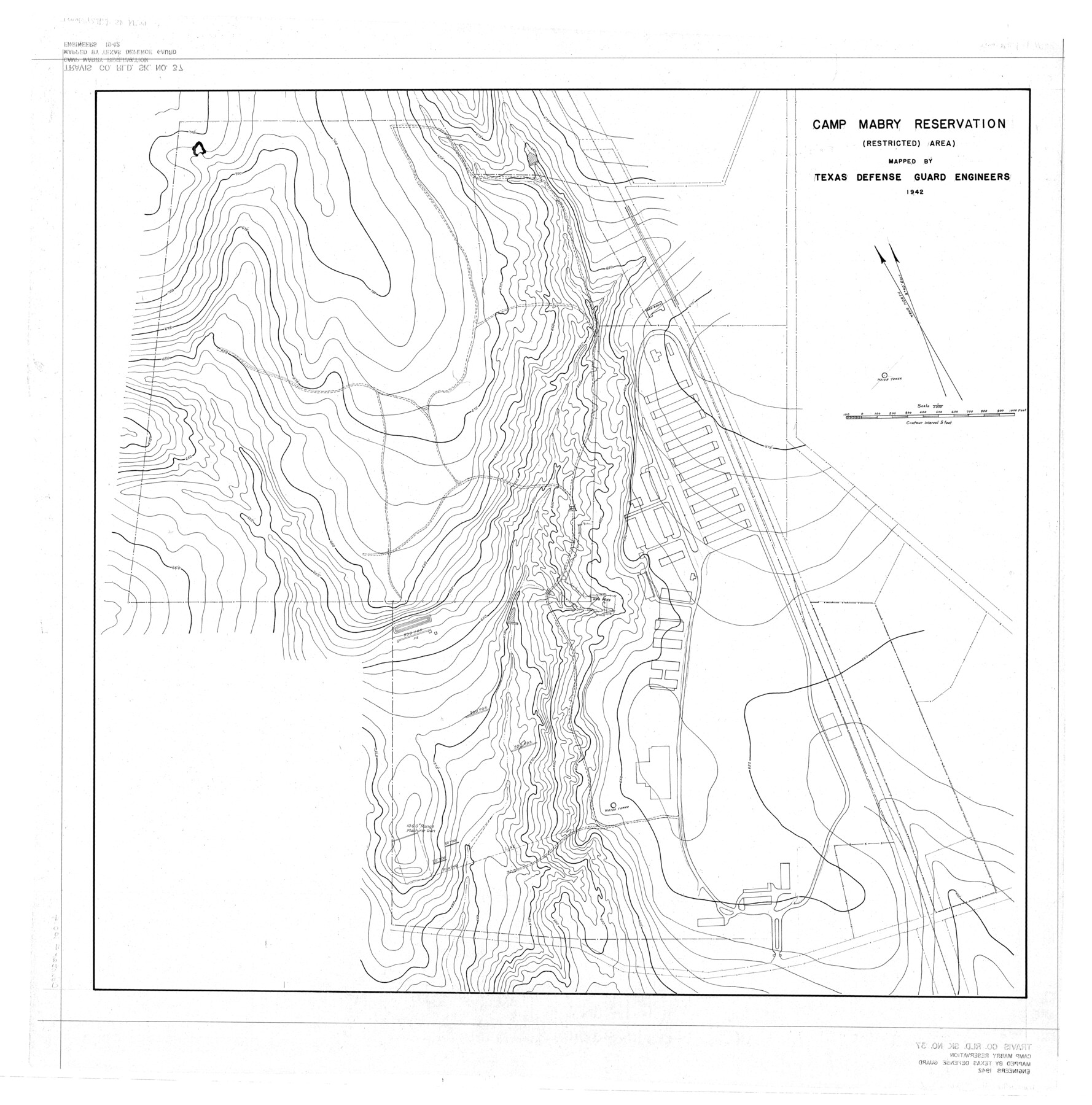
Travis County Rolled Sketch 37
Camp Mabry Reservation (restricted area) mapped by Texas Defense Guard Engineers
-
Map/Doc
10014
-
Collection
General Map Collection
-
Object Dates
1942 (Creation Date)
-
Counties
Travis
-
Subjects
Surveying Rolled Sketch
-
Height x Width
36.1 x 35.6 inches
91.7 x 90.4 cm
Part of: General Map Collection
Sutton County Working Sketch 32

Print $20.00
- Digital $50.00
Sutton County Working Sketch 32
1933
Size 20.5 x 28.3 inches
Map/Doc 62375
Wilbarger County Sketch File 8

Print $4.00
- Digital $50.00
Wilbarger County Sketch File 8
1885
Size 14.2 x 8.6 inches
Map/Doc 40179
Hale County Sketch File 21

Print $20.00
- Digital $50.00
Hale County Sketch File 21
Size 7.0 x 26.6 inches
Map/Doc 11597
Uvalde County Sketch File 17

Print $20.00
- Digital $50.00
Uvalde County Sketch File 17
1882
Size 17.5 x 17.9 inches
Map/Doc 12531
Flight Mission No. DAG-21K, Frame 117, Matagorda County

Print $20.00
- Digital $50.00
Flight Mission No. DAG-21K, Frame 117, Matagorda County
1952
Size 18.5 x 22.4 inches
Map/Doc 86440
La Salle County Working Sketch 16

Print $20.00
- Digital $50.00
La Salle County Working Sketch 16
1936
Size 26.5 x 16.2 inches
Map/Doc 70317
El Paso County Rolled Sketch 43A

Print $20.00
- Digital $50.00
El Paso County Rolled Sketch 43A
Size 23.2 x 22.6 inches
Map/Doc 5829
Hidalgo County Sketch File 1

Print $40.00
- Digital $50.00
Hidalgo County Sketch File 1
Size 20.2 x 12.0 inches
Map/Doc 26392
Nueces County Sketch File 36

Print $20.00
- Digital $50.00
Nueces County Sketch File 36
1913
Size 17.0 x 18.4 inches
Map/Doc 42189
Lubbock County Sketch File 12

Print $6.00
- Digital $50.00
Lubbock County Sketch File 12
1933
Size 11.1 x 8.6 inches
Map/Doc 30435
Callahan County Sketch File 14

Print $40.00
- Digital $50.00
Callahan County Sketch File 14
1938
Size 20.5 x 26.1 inches
Map/Doc 11042
Marion County Working Sketch 14

Print $20.00
- Digital $50.00
Marion County Working Sketch 14
1956
Size 25.1 x 25.0 inches
Map/Doc 70790
You may also like
[G. C. & S. F. Block S, E. L. & R. R. Block M and B9, D. & W. Block 24]
![91278, [G. C. & S. F. Block S, E. L. & R. R. Block M and B9, D. & W. Block 24], Twichell Survey Records](https://historictexasmaps.com/wmedia_w700/maps/91278-1.tif.jpg)
Print $20.00
- Digital $50.00
[G. C. & S. F. Block S, E. L. & R. R. Block M and B9, D. & W. Block 24]
Size 20.7 x 15.7 inches
Map/Doc 91278
Crockett County Sketch File A

Print $40.00
- Digital $50.00
Crockett County Sketch File A
Size 21.9 x 7.5 inches
Map/Doc 19624
Hutchinson County Sketch File 27

Print $20.00
- Digital $50.00
Hutchinson County Sketch File 27
Size 21.0 x 24.9 inches
Map/Doc 11817
Map of the north west portion of Hutchinson County showing the proposed resurvey of Block M24

Print $20.00
- Digital $50.00
Map of the north west portion of Hutchinson County showing the proposed resurvey of Block M24
Size 29.1 x 31.9 inches
Map/Doc 75814
Texas City. First and Second Division

Print $20.00
- Digital $50.00
Texas City. First and Second Division
1892
Size 24.3 x 19.1 inches
Map/Doc 95355
Nueces County Rolled Sketch 110

Print $20.00
- Digital $50.00
Nueces County Rolled Sketch 110
1990
Size 24.1 x 37.5 inches
Map/Doc 7117
Right-of-Way and Track Map, Houston and Brazos Valley Ry. Co. operated by the Houston and Brazos Valley Ry. Co.

Print $40.00
- Digital $50.00
Right-of-Way and Track Map, Houston and Brazos Valley Ry. Co. operated by the Houston and Brazos Valley Ry. Co.
1918
Size 24.9 x 56.5 inches
Map/Doc 64607
Flight Mission No. BRA-7M, Frame 76, Jefferson County

Print $20.00
- Digital $50.00
Flight Mission No. BRA-7M, Frame 76, Jefferson County
1953
Size 18.8 x 22.3 inches
Map/Doc 85498

Hopkins County Sketch File 3

Print $4.00
- Digital $50.00
Hopkins County Sketch File 3
Size 10.0 x 8.1 inches
Map/Doc 26685
Map of San Augustine County

Print $40.00
- Digital $50.00
Map of San Augustine County
1901
Size 48.8 x 29.3 inches
Map/Doc 16807
Map of Panola County

Print $20.00
- Digital $50.00
Map of Panola County
1871
Size 16.5 x 17.7 inches
Map/Doc 3938