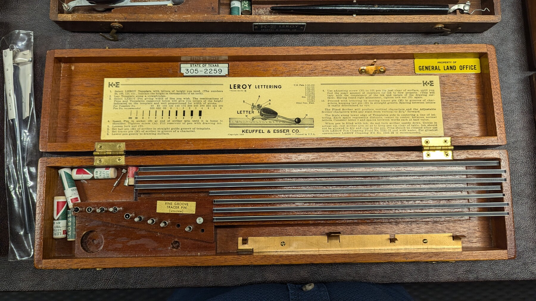
K&E Leroy Lettering Set - 3240
Manufacturer: Keuffel & Esser Co. State Inventory Tag: 305-2259 Case: Wooden Box Manufacture Location: Hoboken
-
Map/Doc
97313
-
Collection
General Map Collection
-
Object Dates
1950 (Creation Date)
-
Height x Width
1.8 x 15.8 inches
4.4 x 40.0 cm
Part of: General Map Collection
Shelby County Working Sketch 21

Print $6.00
- Digital $50.00
Shelby County Working Sketch 21
Size 31.0 x 23.3 inches
Map/Doc 63874
Fannin County Working Sketch 7

Print $20.00
- Digital $50.00
Fannin County Working Sketch 7
1952
Size 25.4 x 28.5 inches
Map/Doc 69161
Flight Mission No. DQO-1K, Frame 40, Galveston County

Print $20.00
- Digital $50.00
Flight Mission No. DQO-1K, Frame 40, Galveston County
1952
Size 18.8 x 22.6 inches
Map/Doc 84983
Kendall County Boundary File 3

Print $36.00
- Digital $50.00
Kendall County Boundary File 3
Size 9.4 x 37.5 inches
Map/Doc 55756
Hutchinson County Sketch File 4

Print $32.00
- Digital $50.00
Hutchinson County Sketch File 4
1890
Size 14.2 x 8.7 inches
Map/Doc 27179
Matagorda County Sketch File 15

Print $48.00
- Digital $50.00
Matagorda County Sketch File 15
Size 8.7 x 11.2 inches
Map/Doc 30774
Brazoria County Working Sketch 19

Print $40.00
- Digital $50.00
Brazoria County Working Sketch 19
1951
Size 50.3 x 42.3 inches
Map/Doc 67504
Hardin County Sketch File 21

Print $4.00
- Digital $50.00
Hardin County Sketch File 21
Size 11.2 x 8.8 inches
Map/Doc 25140
East Part El Paso County

Print $20.00
- Digital $50.00
East Part El Paso County
1908
Size 47.6 x 40.9 inches
Map/Doc 66814
Johnson County Working Sketch 30

Print $20.00
- Digital $50.00
Johnson County Working Sketch 30
2007
Size 40.9 x 42.0 inches
Map/Doc 83807
Dawson County Boundary File 1

Print $48.00
- Digital $50.00
Dawson County Boundary File 1
Size 8.8 x 4.0 inches
Map/Doc 52314
Bell County Boundary File 1

Print $8.00
- Digital $50.00
Bell County Boundary File 1
Size 14.0 x 8.5 inches
Map/Doc 50481
You may also like
Young County Rolled Sketch 13

Print $20.00
- Digital $50.00
Young County Rolled Sketch 13
1966
Size 24.8 x 16.9 inches
Map/Doc 8301
Hudspeth County Working Sketch 11

Print $20.00
- Digital $50.00
Hudspeth County Working Sketch 11
1946
Size 32.1 x 36.2 inches
Map/Doc 66292
[Surveys along the Neches River in Jasper District]
![69733, [Surveys along the Neches River in Jasper District], General Map Collection](https://historictexasmaps.com/wmedia_w700/maps/69733.tif.jpg)
Print $2.00
- Digital $50.00
[Surveys along the Neches River in Jasper District]
1847
Size 9.2 x 6.8 inches
Map/Doc 69733
Flight Mission No. BRE-1P, Frame 97, Nueces County

Print $20.00
- Digital $50.00
Flight Mission No. BRE-1P, Frame 97, Nueces County
1956
Size 18.3 x 22.0 inches
Map/Doc 86668
Motley County

Print $20.00
- Digital $50.00
Motley County
1914
Size 47.7 x 37.4 inches
Map/Doc 10797
Flight Mission No. DQN-2K, Frame 92, Calhoun County

Print $20.00
- Digital $50.00
Flight Mission No. DQN-2K, Frame 92, Calhoun County
1953
Size 18.6 x 22.2 inches
Map/Doc 84282
Greater Austin, Texas Streetmap

Greater Austin, Texas Streetmap
Size 45.8 x 36.2 inches
Map/Doc 94431
Webb County Sketch File 3

Print $8.00
- Digital $50.00
Webb County Sketch File 3
Size 9.8 x 9.3 inches
Map/Doc 39713
Right of Way and Track Map, Houston & Texas Central R.R. operated by the T. and N. O. R.R., Fort Worth Branch

Print $40.00
- Digital $50.00
Right of Way and Track Map, Houston & Texas Central R.R. operated by the T. and N. O. R.R., Fort Worth Branch
1918
Size 30.9 x 56.9 inches
Map/Doc 64783


Flight Mission No. DQO-3K, Frame 27, Galveston County

Print $20.00
- Digital $50.00
Flight Mission No. DQO-3K, Frame 27, Galveston County
1952
Size 18.7 x 22.5 inches
Map/Doc 85068