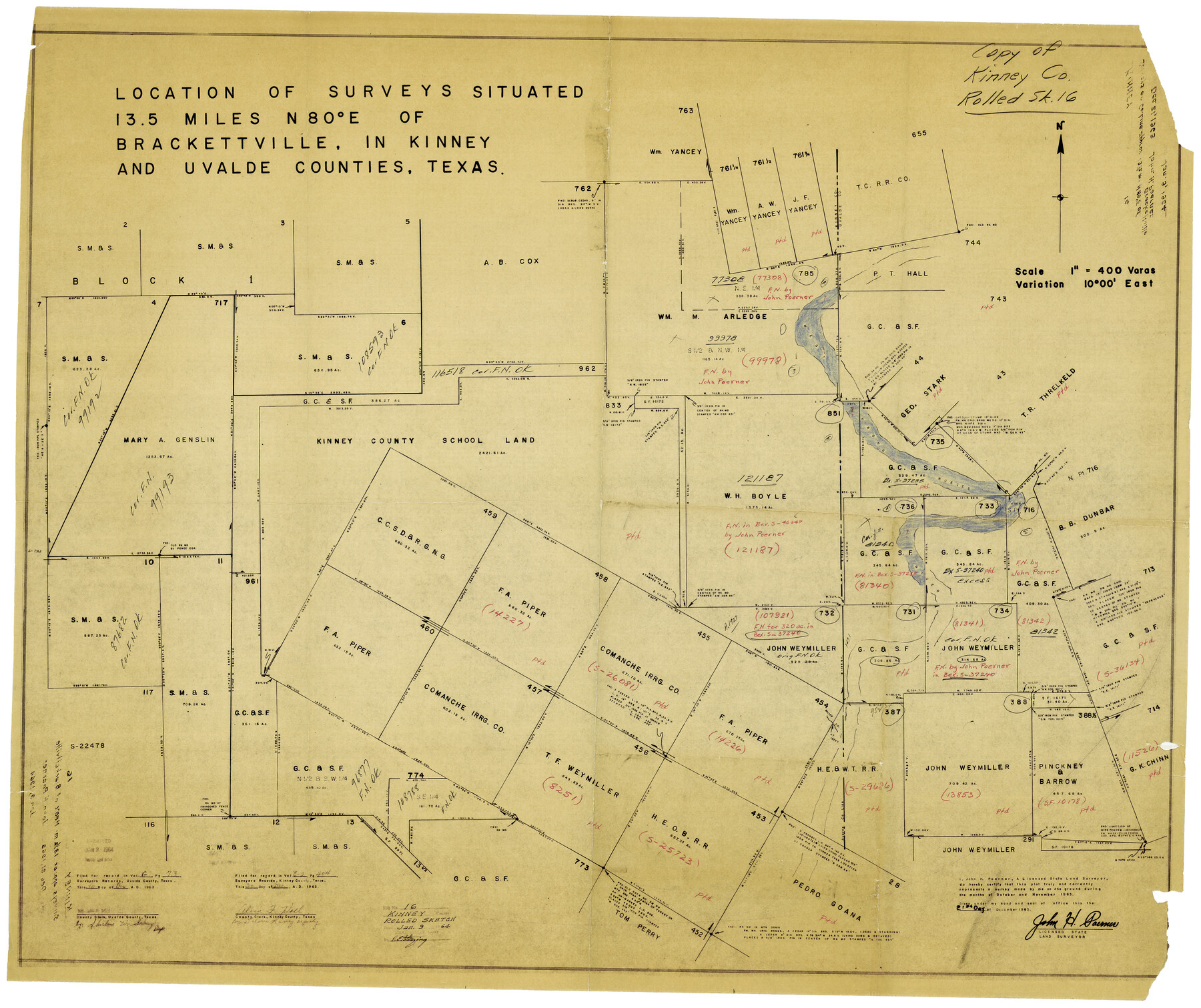
Kinney County Rolled Sketch 16
Location of surveys situated in Kinney and Uvalde Counties, east of Brackettville
-
Map/Doc
9355
-
Collection
General Map Collection
-
Object Dates
12/21/1963 (Creation Date)
1/9/1964 (File Date)
-
People and Organizations
John H. Poerner (Surveyor/Engineer)
-
Counties
Kinney Uvalde
-
Subjects
Surveying Rolled Sketch
-
Height x Width
37.4 x 44.7 inches
95.0 x 113.5 cm
-
Medium
van dyke/brownline/sepia
-
Scale
1" = 400 varas
Part of: General Map Collection
Flight Mission No. DIX-6P, Frame 115, Aransas County

Print $20.00
- Digital $50.00
Flight Mission No. DIX-6P, Frame 115, Aransas County
1956
Size 19.3 x 22.8 inches
Map/Doc 83821
Polk County Rolled Sketch TS

Print $40.00
- Digital $50.00
Polk County Rolled Sketch TS
1937
Size 37.9 x 58.9 inches
Map/Doc 9755
Anderson County Working Sketch 23

Print $20.00
- Digital $50.00
Anderson County Working Sketch 23
1958
Size 23.1 x 24.8 inches
Map/Doc 67023
Wichita County Sketch File 20

Print $20.00
- Digital $50.00
Wichita County Sketch File 20
Size 12.0 x 22.5 inches
Map/Doc 12683
Presidio County Working Sketch 118

Print $20.00
- Digital $50.00
Presidio County Working Sketch 118
1983
Size 47.4 x 41.6 inches
Map/Doc 71795
Flight Mission No. CUG-3P, Frame 41, Kleberg County

Print $20.00
- Digital $50.00
Flight Mission No. CUG-3P, Frame 41, Kleberg County
1956
Size 18.3 x 22.1 inches
Map/Doc 86246
Borden County Boundary File 5a

Print $98.00
- Digital $50.00
Borden County Boundary File 5a
Size 13.3 x 8.1 inches
Map/Doc 50659

San Patricio County Sketch File 31

Print $6.00
- Digital $50.00
San Patricio County Sketch File 31
Size 14.0 x 10.0 inches
Map/Doc 36117
[Peter's Colony surveys in Stephens County]
![75986, [Peter's Colony surveys in Stephens County], General Map Collection](https://historictexasmaps.com/wmedia_w700/maps/75986.tif.jpg)
Print $20.00
- Digital $50.00
[Peter's Colony surveys in Stephens County]
Size 25.3 x 21.1 inches
Map/Doc 75986
Floyd County Sketch File 20

Print $4.00
- Digital $50.00
Floyd County Sketch File 20
1914
Size 14.5 x 8.9 inches
Map/Doc 22772
In the Supreme Court of the United States The State of Oklahoma, Complainant vs. The State of Texas, Defendant, The United States of America, Intervener - 1920

Print $20.00
- Digital $50.00
In the Supreme Court of the United States The State of Oklahoma, Complainant vs. The State of Texas, Defendant, The United States of America, Intervener - 1920
1920
Size 39.4 x 35.6 inches
Map/Doc 75111
You may also like
Angelina County Sketch File 27

Print $10.00
- Digital $50.00
Angelina County Sketch File 27
1890
Size 14.1 x 8.7 inches
Map/Doc 13073
Runnels County Rolled Sketch 50

Print $20.00
- Digital $50.00
Runnels County Rolled Sketch 50
Size 31.3 x 26.7 inches
Map/Doc 7535
Young County Boundary File 1

Print $8.00
- Digital $50.00
Young County Boundary File 1
Size 10.3 x 8.2 inches
Map/Doc 60198
Hutson Addition to Umbarger, sec. 76, Blk. B-5, Randall Co., Texas

Print $20.00
- Digital $50.00
Hutson Addition to Umbarger, sec. 76, Blk. B-5, Randall Co., Texas
Size 30.5 x 29.5 inches
Map/Doc 92155
Webb County Sketch File 44a

Print $20.00
- Digital $50.00
Webb County Sketch File 44a
1936
Size 29.4 x 18.2 inches
Map/Doc 12640
Williamson County Working Sketch 12

Print $20.00
- Digital $50.00
Williamson County Working Sketch 12
1977
Size 37.0 x 35.0 inches
Map/Doc 72572
Sutton County Rolled Sketch 58

Print $20.00
- Digital $50.00
Sutton County Rolled Sketch 58
Size 31.2 x 15.9 inches
Map/Doc 7896
Map of lands owned by R.E. Montgomery in Martin and Andrews County, Texas

Print $20.00
- Digital $50.00
Map of lands owned by R.E. Montgomery in Martin and Andrews County, Texas
Size 20.0 x 24.5 inches
Map/Doc 75764
Map of east part of West Bay & SW part of Galveston Bay, Galveston County showing subdivision for mineral development

Print $40.00
- Digital $50.00
Map of east part of West Bay & SW part of Galveston Bay, Galveston County showing subdivision for mineral development
Size 69.6 x 48.0 inches
Map/Doc 65804
Newton County Rolled Sketch 25

Print $20.00
- Digital $50.00
Newton County Rolled Sketch 25
1893
Size 22.3 x 18.6 inches
Map/Doc 6852
Flight Mission No. CGI-3N, Frame 53, Cameron County

Print $20.00
- Digital $50.00
Flight Mission No. CGI-3N, Frame 53, Cameron County
1954
Size 18.5 x 22.2 inches
Map/Doc 84559
