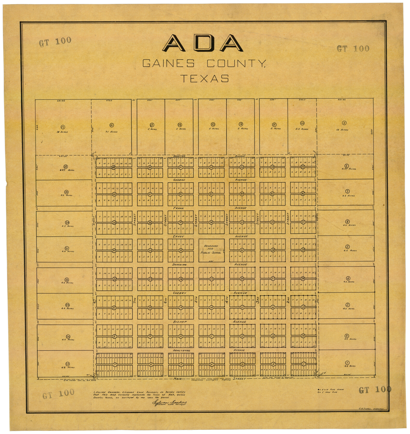
Ada, Gaines County, Texas
GT100
-
Map/Doc
92689
-
Collection
Twichell Survey Records
-
People and Organizations
Sylvan Sanders (Surveyor/Engineer)
C.A. Tubbs (Draftsman)
-
Counties
Gaines
-
Height x Width
24.1 x 25.8 inches
61.2 x 65.5 cm
Part of: Twichell Survey Records
Working Sketch in Stephens County

Print $20.00
- Digital $50.00
Working Sketch in Stephens County
1919
Size 11.1 x 20.6 inches
Map/Doc 91903
[Blocks K5-K7]
![90538, [Blocks K5-K7], Twichell Survey Records](https://historictexasmaps.com/wmedia_w700/maps/90538-1.tif.jpg)
Print $3.00
- Digital $50.00
[Blocks K5-K7]
1902
Size 12.5 x 11.5 inches
Map/Doc 90538
[Block 3 Sections 322, 321, 319, Block 1 Section 1]
![92938, [Block 3 Sections 322, 321, 319, Block 1 Section 1], Twichell Survey Records](https://historictexasmaps.com/wmedia_w700/maps/92938-1.tif.jpg)
Print $20.00
- Digital $50.00
[Block 3 Sections 322, 321, 319, Block 1 Section 1]
Size 21.1 x 20.4 inches
Map/Doc 92938
[Sections Surrounding Sections 111, 90, 112, 89]
![92131, [Sections Surrounding Sections 111, 90, 112, 89], Twichell Survey Records](https://historictexasmaps.com/wmedia_w700/maps/92131-1.tif.jpg)
Print $20.00
- Digital $50.00
[Sections Surrounding Sections 111, 90, 112, 89]
Size 15.5 x 26.2 inches
Map/Doc 92131
Map of S. E. Pecos County with a part of Crockett County, Texas

Print $40.00
- Digital $50.00
Map of S. E. Pecos County with a part of Crockett County, Texas
1927
Size 42.2 x 51.6 inches
Map/Doc 89804
[Guadalupe, San Miguel, and other Counties, N.M.]
![89818, [Guadalupe, San Miguel, and other Counties, N.M.], Twichell Survey Records](https://historictexasmaps.com/wmedia_w700/maps/89818-1.tif.jpg)
Print $40.00
- Digital $50.00
[Guadalupe, San Miguel, and other Counties, N.M.]
Size 39.6 x 57.1 inches
Map/Doc 89818
[Sketch of J.D. Brown survey and vicinity]
![89965, [Sketch of J.D. Brown survey and vicinity], Twichell Survey Records](https://historictexasmaps.com/wmedia_w700/maps/89965-1.tif.jpg)
Print $40.00
- Digital $50.00
[Sketch of J.D. Brown survey and vicinity]
Size 43.5 x 63.0 inches
Map/Doc 89965
Sketch Showing Original Corners Affecting Block I and Adjacent Surveys from Actual Connections by W. D. Twichell

Print $20.00
- Digital $50.00
Sketch Showing Original Corners Affecting Block I and Adjacent Surveys from Actual Connections by W. D. Twichell
Size 23.6 x 24.5 inches
Map/Doc 90156
Flake Addition a Subdivision of SE Part of NE Quarter Section 4, Block O

Print $20.00
- Digital $50.00
Flake Addition a Subdivision of SE Part of NE Quarter Section 4, Block O
Size 27.4 x 19.5 inches
Map/Doc 92823
Gregg County School Land League 2

Print $20.00
- Digital $50.00
Gregg County School Land League 2
Size 15.6 x 15.5 inches
Map/Doc 90613
The Great Lakes Region of the United States and Canada

The Great Lakes Region of the United States and Canada
1953
Size 42.5 x 28.6 inches
Map/Doc 92396
Working Sketch Dickens and Kent Counties

Print $20.00
- Digital $50.00
Working Sketch Dickens and Kent Counties
1904
Size 16.3 x 20.7 inches
Map/Doc 90862
You may also like
Bexar County Working Sketch 3

Print $20.00
- Digital $50.00
Bexar County Working Sketch 3
1941
Size 19.6 x 21.6 inches
Map/Doc 67319
Jasper County

Print $20.00
- Digital $50.00
Jasper County
1882
Size 17.6 x 14.0 inches
Map/Doc 75779
[Sketch for Mineral Application 13439 - Bed Lost Lake, Walle Merritt]
![65578, [Sketch for Mineral Application 13439 - Bed Lost Lake, Walle Merritt], General Map Collection](https://historictexasmaps.com/wmedia_w700/maps/65578.tif.jpg)
Print $20.00
- Digital $50.00
[Sketch for Mineral Application 13439 - Bed Lost Lake, Walle Merritt]
1925
Size 31.0 x 29.6 inches
Map/Doc 65578

Howard County Working Sketch 11

Print $20.00
- Digital $50.00
Howard County Working Sketch 11
1962
Size 20.5 x 20.3 inches
Map/Doc 66279
Flight Mission No. DIX-10P, Frame 77, Aransas County

Print $20.00
- Digital $50.00
Flight Mission No. DIX-10P, Frame 77, Aransas County
1956
Size 18.6 x 22.3 inches
Map/Doc 83938
Flight Mission No. CLL-1N, Frame 85, Willacy County

Print $20.00
- Digital $50.00
Flight Mission No. CLL-1N, Frame 85, Willacy County
1954
Size 18.4 x 22.1 inches
Map/Doc 87031
Brewster County Working Sketch 53

Print $20.00
- Digital $50.00
Brewster County Working Sketch 53
1951
Size 32.1 x 16.5 inches
Map/Doc 67587
Terry County Boundary File 2a

Print $32.00
- Digital $50.00
Terry County Boundary File 2a
Size 11.6 x 8.9 inches
Map/Doc 59209
Carta Esferica que comprehende las costas del Seno Mexicano construida de orden del rey en el deposito hidrografico de marina: Por disposicion del Exmo. Señor Don Juan de Langara, Secretario de Estado y del Despacho Universal de ella. Año de 1799.

Print $20.00
- Digital $50.00
Carta Esferica que comprehende las costas del Seno Mexicano construida de orden del rey en el deposito hidrografico de marina: Por disposicion del Exmo. Señor Don Juan de Langara, Secretario de Estado y del Despacho Universal de ella. Año de 1799.
1799
Size 25.9 x 37.3 inches
Map/Doc 95367
[Galveston, Harrisburg & San Antonio Railroad from Cuero to Stockdale]
![64198, [Galveston, Harrisburg & San Antonio Railroad from Cuero to Stockdale], General Map Collection](https://historictexasmaps.com/wmedia_w700/maps/64198.tif.jpg)
Print $20.00
- Digital $50.00
[Galveston, Harrisburg & San Antonio Railroad from Cuero to Stockdale]
1907
Size 13.9 x 34.1 inches
Map/Doc 64198
From Citizens Living in Gonzales and Victoria Counties for the Creation of a New Judicial County to be Called Guadalupe, Undated

Print $20.00
From Citizens Living in Gonzales and Victoria Counties for the Creation of a New Judicial County to be Called Guadalupe, Undated
2020
Size 24.5 x 21.7 inches
Map/Doc 96413