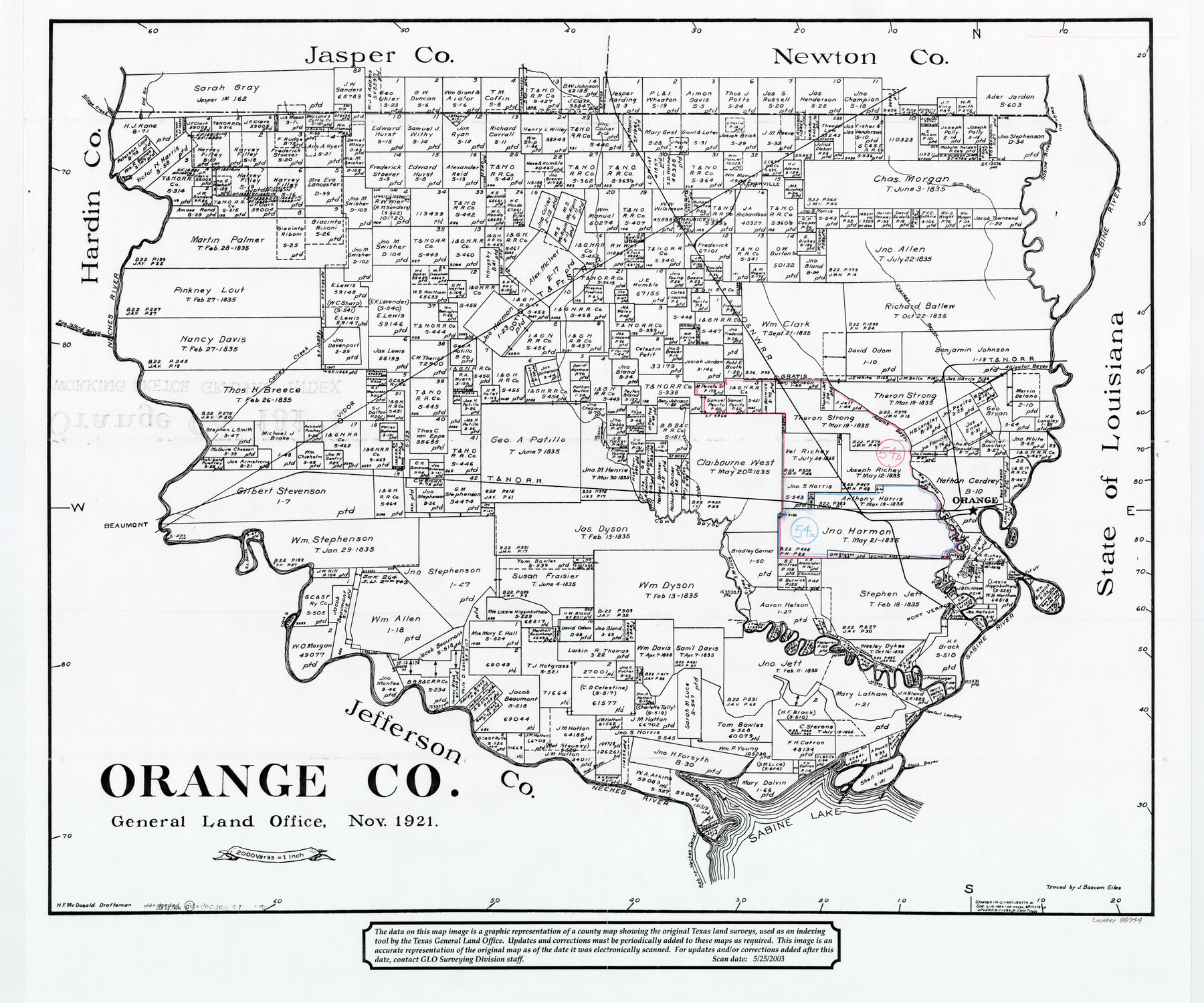
Orange County Working Sketch Graphic Index - sheet B
-
Map/Doc
88744
-
Collection
General Map Collection
-
Object Dates
11/1921 (Creation Date)
-
People and Organizations
H.F. McDonald (Draftsman)
J. Bascom Giles (Draftsman)
-
Counties
Orange
-
Subjects
County Surveying Working Sketch
-
Height x Width
25.2 x 30.2 inches
64.0 x 76.7 cm
-
Scale
1" = 2000 varas
Part of: General Map Collection
Kimble County Working Sketch 90

Print $20.00
- Digital $50.00
Kimble County Working Sketch 90
1979
Size 17.3 x 28.2 inches
Map/Doc 70158
Moore County Rolled Sketch 6

Print $20.00
- Digital $50.00
Moore County Rolled Sketch 6
1911
Size 33.4 x 30.2 inches
Map/Doc 6825

Edwards County

Print $20.00
- Digital $50.00
Edwards County
1893
Size 30.8 x 33.1 inches
Map/Doc 3507
Carte d'une partie de L'Amérique Séptentrionale, qui contient partie de la Nle. Espagne, et de la Louisiane

Print $20.00
- Digital $50.00
Carte d'une partie de L'Amérique Séptentrionale, qui contient partie de la Nle. Espagne, et de la Louisiane
1782
Size 14.1 x 18.1 inches
Map/Doc 97118
Spanish Province of Texas compiled from map on file among archives at Saltillo

Print $20.00
- Digital $50.00
Spanish Province of Texas compiled from map on file among archives at Saltillo
1897
Size 13.6 x 16.0 inches
Map/Doc 93412
Edwards County Sketch File 8

Print $20.00
- Digital $50.00
Edwards County Sketch File 8
Size 36.7 x 18.5 inches
Map/Doc 11420
Burnet County Sketch File 38

Print $20.00
- Digital $50.00
Burnet County Sketch File 38
1935
Size 37.8 x 24.5 inches
Map/Doc 11027
Atascosa County Rolled Sketch 21

Print $20.00
- Digital $50.00
Atascosa County Rolled Sketch 21
1958
Size 25.0 x 38.0 inches
Map/Doc 5100
Donley County Sketch File B12

Print $6.00
- Digital $50.00
Donley County Sketch File B12
1982
Size 9.1 x 14.6 inches
Map/Doc 21276
Limestone County Boundary File 1

Print $9.00
- Digital $50.00
Limestone County Boundary File 1
Size 8.8 x 14.5 inches
Map/Doc 56296
Fort Bend County Boundary File 2

Print $8.00
- Digital $50.00
Fort Bend County Boundary File 2
Size 14.3 x 8.9 inches
Map/Doc 53559
You may also like
Stonewall County Working Sketch 29

Print $40.00
- Digital $50.00
Stonewall County Working Sketch 29
1979
Size 48.5 x 43.0 inches
Map/Doc 62336
Eastham Farm, Texas Prison System, Houston County

Print $20.00
- Digital $50.00
Eastham Farm, Texas Prison System, Houston County
Size 17.3 x 18.4 inches
Map/Doc 62988
Briscoe County Sketch File A

Print $40.00
- Digital $50.00
Briscoe County Sketch File A
1894
Size 17.3 x 21.1 inches
Map/Doc 10997
Flight Mission No. DQN-3K, Frame 75, Calhoun County

Print $20.00
- Digital $50.00
Flight Mission No. DQN-3K, Frame 75, Calhoun County
1953
Size 18.6 x 22.4 inches
Map/Doc 84366
Swisher County Working Sketch Graphic Index

Print $20.00
- Digital $50.00
Swisher County Working Sketch Graphic Index
1941
Size 41.5 x 35.9 inches
Map/Doc 76707
Wilbarger County Sketch File 12

Print $8.00
- Digital $50.00
Wilbarger County Sketch File 12
Size 12.7 x 8.1 inches
Map/Doc 40185
Coke County Boundary File Index

Print $2.00
- Digital $50.00
Coke County Boundary File Index
Size 8.9 x 14.2 inches
Map/Doc 65461
Edwards County Working Sketch 106

Print $20.00
- Digital $50.00
Edwards County Working Sketch 106
1972
Size 32.3 x 26.5 inches
Map/Doc 68982
Presidio County Rolled Sketch 137

Print $20.00
- Digital $50.00
Presidio County Rolled Sketch 137
1999
Size 38.7 x 47.9 inches
Map/Doc 8352
La Salle County Sketch File 12

Print $15.00
- Digital $50.00
La Salle County Sketch File 12
1877
Size 10.0 x 8.1 inches
Map/Doc 29470
Hutchinson County Sketch File 48

Print $38.00
- Digital $50.00
Hutchinson County Sketch File 48
1989
Size 11.2 x 8.8 inches
Map/Doc 27400
Township 8 North Range 14 West, North Western District, Louisiana

Print $20.00
- Digital $50.00
Township 8 North Range 14 West, North Western District, Louisiana
1854
Size 19.7 x 24.7 inches
Map/Doc 65874