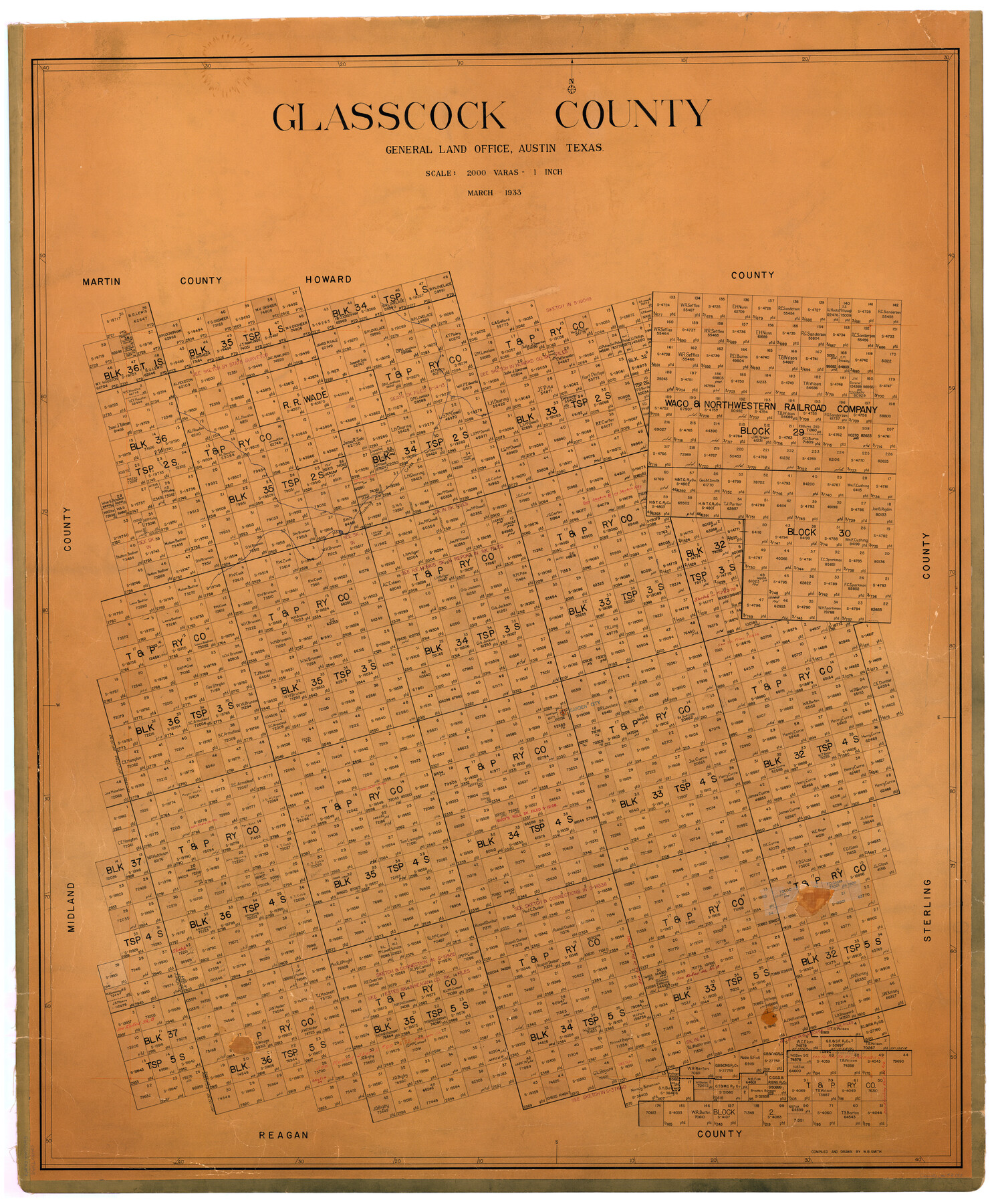
Glasscock County
-
Map/Doc
73158
-
Collection
General Map Collection
-
Object Dates
1933 (Creation Date)
-
People and Organizations
Texas General Land Office (Publisher)
W.B. Smith (Compiler)
W.B. Smith (Draftsman)
-
Counties
Glasscock
-
Subjects
County
-
Height x Width
45.1 x 37.6 inches
114.6 x 95.5 cm
-
Comments
Hand lettered.
Note on reverse side: "Hung March 3, 1933, W. B. Smith." -
Features
Mustang Creek
Garden City
Part of: General Map Collection
Uvalde County Sketch File 32

Print $12.00
- Digital $50.00
Uvalde County Sketch File 32
2008
Size 8.5 x 11.0 inches
Map/Doc 89025
Dawson County Working Sketch 10

Print $20.00
- Digital $50.00
Dawson County Working Sketch 10
1944
Size 15.6 x 13.6 inches
Map/Doc 68554
Flight Mission No. DQN-2K, Frame 136, Calhoun County

Print $20.00
- Digital $50.00
Flight Mission No. DQN-2K, Frame 136, Calhoun County
1953
Size 18.5 x 15.8 inches
Map/Doc 84305
Val Verde County Working Sketch 26

Print $20.00
- Digital $50.00
Val Verde County Working Sketch 26
1936
Size 22.9 x 31.5 inches
Map/Doc 72161

Crockett County Rolled Sketch 46

Print $20.00
- Digital $50.00
Crockett County Rolled Sketch 46
1938
Size 46.0 x 43.0 inches
Map/Doc 8711
Hidalgo County Sketch File 4

Print $20.00
- Digital $50.00
Hidalgo County Sketch File 4
Size 21.4 x 25.2 inches
Map/Doc 11760
Flight Mission No. DQO-8K, Frame 21, Galveston County

Print $20.00
- Digital $50.00
Flight Mission No. DQO-8K, Frame 21, Galveston County
1952
Size 18.6 x 22.3 inches
Map/Doc 85144
Pecos County Sketch File 29

Print $20.00
- Digital $50.00
Pecos County Sketch File 29
1929
Size 26.1 x 15.8 inches
Map/Doc 12170
Tyler County Rolled Sketch 1

Print $20.00
- Digital $50.00
Tyler County Rolled Sketch 1
1941
Size 16.4 x 19.7 inches
Map/Doc 8055
Bandera County Working Sketch 10

Print $20.00
- Digital $50.00
Bandera County Working Sketch 10
1922
Size 17.9 x 19.4 inches
Map/Doc 67603
Milam County Working Sketch 11

Print $20.00
- Digital $50.00
Milam County Working Sketch 11
1987
Size 43.8 x 31.9 inches
Map/Doc 71026
You may also like
Galveston County Sketch File 13

Print $20.00
- Digital $50.00
Galveston County Sketch File 13
Size 16.2 x 12.5 inches
Map/Doc 11530

Working Sketch from Fisher County [around Roby]
![90911, Working Sketch from Fisher County [around Roby], Twichell Survey Records](https://historictexasmaps.com/wmedia_w700/maps/90911-1.tif.jpg)
Print $20.00
- Digital $50.00
Working Sketch from Fisher County [around Roby]
1901
Size 22.7 x 31.1 inches
Map/Doc 90911
Trinity River, Oliver Crossing Sheet/Chambers Creek

Print $6.00
- Digital $50.00
Trinity River, Oliver Crossing Sheet/Chambers Creek
1931
Size 30.1 x 28.2 inches
Map/Doc 65231
Gonzales County

Print $20.00
- Digital $50.00
Gonzales County
1880
Size 25.3 x 22.6 inches
Map/Doc 3594
Map of Freestone County

Print $20.00
- Digital $50.00
Map of Freestone County
1888
Size 27.0 x 22.3 inches
Map/Doc 3561
Flight Mission No. DIX-6P, Frame 180, Aransas County

Print $20.00
- Digital $50.00
Flight Mission No. DIX-6P, Frame 180, Aransas County
1956
Size 19.0 x 22.6 inches
Map/Doc 83842
Upton County Sketch File D

Print $12.00
- Digital $50.00
Upton County Sketch File D
Size 13.6 x 9.0 inches
Map/Doc 38854

Jefferson County Sketch File 34

Print $9.00
- Digital $50.00
Jefferson County Sketch File 34
1900
Size 10.9 x 7.1 inches
Map/Doc 28203
Map of Reeves County

Print $20.00
- Digital $50.00
Map of Reeves County
1892
Size 44.8 x 34.0 inches
Map/Doc 3983
Map of Part of Espiritu Santo and San Antonio Bays and Vicinity, Texas

Print $40.00
- Digital $50.00
Map of Part of Espiritu Santo and San Antonio Bays and Vicinity, Texas
1859
Size 31.6 x 53.1 inches
Map/Doc 69983