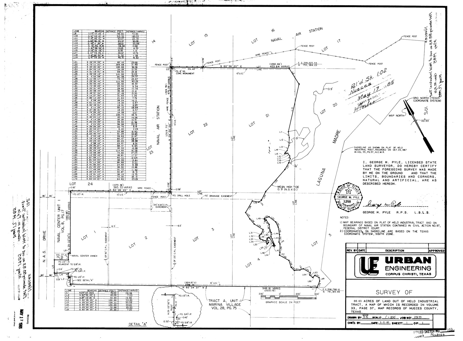
Nueces County Rolled Sketch 102
[Sketches, correspondence, and aerial photographs relating to 88.83 acres of land out of Held Industrial Tract]
-
Map/Doc
7068
-
Collection
General Map Collection
-
Object Dates
1985 (Creation Date)
1985 (File Date)
-
People and Organizations
George M. Pyle (Surveyor/Engineer)
-
Counties
Nueces
-
Subjects
Surveying Rolled Sketch
-
Height x Width
18.2 x 24.7 inches
46.2 x 62.7 cm
Part of: General Map Collection
Nueces County Rolled Sketch 83

Print $40.00
- Digital $50.00
Nueces County Rolled Sketch 83
1973
Size 20.1 x 48.7 inches
Map/Doc 9629
Flight Mission No. DAG-23K, Frame 181, Matagorda County

Print $20.00
- Digital $50.00
Flight Mission No. DAG-23K, Frame 181, Matagorda County
1953
Size 18.7 x 22.4 inches
Map/Doc 86516
Brewster County Rolled Sketch 152

Print $20.00
- Digital $50.00
Brewster County Rolled Sketch 152
1996
Size 28.0 x 36.5 inches
Map/Doc 5319
Right of Way San Antonio and Aransas Pass Railway

Print $4.00
- Digital $50.00
Right of Way San Antonio and Aransas Pass Railway
1919
Size 11.6 x 18.5 inches
Map/Doc 62561
Map of Angelina County

Print $40.00
- Digital $50.00
Map of Angelina County
1899
Size 40.1 x 53.6 inches
Map/Doc 4868
Marion County Boundary File 61

Print $6.00
- Digital $50.00
Marion County Boundary File 61
Size 12.8 x 8.2 inches
Map/Doc 56816
[Sketch for Mineral Application 26649-26650 - Sabine River, Harry A. Wolan]
![65566, [Sketch for Mineral Application 26649-26650 - Sabine River, Harry A. Wolan], General Map Collection](https://historictexasmaps.com/wmedia_w700/maps/65566.tif.jpg)
Print $40.00
- Digital $50.00
[Sketch for Mineral Application 26649-26650 - Sabine River, Harry A. Wolan]
Size 72.0 x 36.9 inches
Map/Doc 65566
Cherokee County Sketch File 1

Print $6.00
- Digital $50.00
Cherokee County Sketch File 1
1857
Size 10.6 x 8.0 inches
Map/Doc 18109
Mitchell's New Intermediate Geography (Louisiana Edition)

Print $819.00
- Digital $50.00
Mitchell's New Intermediate Geography (Louisiana Edition)
1885
Size 12.5 x 10.0 inches
Map/Doc 93509
United States

Print $40.00
- Digital $50.00
United States
1961
Size 55.0 x 81.2 inches
Map/Doc 75922
A map of Lewis and Clark's track across the western portion of North America from the Mississippi to the Pacific Ocean, by Order of the executive of the United States in 1804, 5, & 6

Print $20.00
- Digital $50.00
A map of Lewis and Clark's track across the western portion of North America from the Mississippi to the Pacific Ocean, by Order of the executive of the United States in 1804, 5, & 6
1814
Size 13.3 x 27.9 inches
Map/Doc 97412
Ward County Rolled Sketch 24E

Print $40.00
- Digital $50.00
Ward County Rolled Sketch 24E
1967
Size 42.3 x 64.9 inches
Map/Doc 10116
You may also like
From Citizens Living Between the Brazos and Trinity Rivers and Below the Old San Antonio Road in Montgomery and Washington Counties for the Creation of a New County to be Called Travis, Undated

Print $20.00
From Citizens Living Between the Brazos and Trinity Rivers and Below the Old San Antonio Road in Montgomery and Washington Counties for the Creation of a New County to be Called Travis, Undated
2020
Size 21.2 x 21.7 inches
Map/Doc 96401
General Highway Map, Llano County, Texas

Print $20.00
General Highway Map, Llano County, Texas
1961
Size 18.2 x 24.6 inches
Map/Doc 79576
El Paso County Rolled Sketch 42

Print $20.00
- Digital $50.00
El Paso County Rolled Sketch 42
Size 34.5 x 24.5 inches
Map/Doc 5828
The Republic County of Brazoria. Proposed, Late Fall 1837-January 1, 1838

Print $20.00
The Republic County of Brazoria. Proposed, Late Fall 1837-January 1, 1838
2020
Size 13.0 x 21.7 inches
Map/Doc 96110
A Geographically Correct Map of the State of Texas

Print $20.00
- Digital $50.00
A Geographically Correct Map of the State of Texas
1876
Size 20.0 x 21.5 inches
Map/Doc 93397
Matagorda County Rolled Sketch 25

Print $115.00
- Digital $50.00
Matagorda County Rolled Sketch 25
Size 9.7 x 15.0 inches
Map/Doc 46624
Reagan County Sketch File 8

Print $20.00
- Digital $50.00
Reagan County Sketch File 8
Size 25.6 x 47.6 inches
Map/Doc 10584
Cameron County

Print $20.00
- Digital $50.00
Cameron County
1913
Size 29.8 x 33.9 inches
Map/Doc 66746
Brazoria County NRC Article 33.136 Sketch 29

Print $24.00
Brazoria County NRC Article 33.136 Sketch 29
2025
Map/Doc 97474
Roberts County Boundary File 2

Print $12.00
- Digital $50.00
Roberts County Boundary File 2
Size 9.9 x 6.4 inches
Map/Doc 58333
Hidalgo County Working Sketch 9

Print $20.00
- Digital $50.00
Hidalgo County Working Sketch 9
1984
Size 27.2 x 15.0 inches
Map/Doc 66186
Trace of a copy of the map captured at the battle of Resaca de la Palma

Print $20.00
- Digital $50.00
Trace of a copy of the map captured at the battle of Resaca de la Palma
Size 18.3 x 27.6 inches
Map/Doc 73053