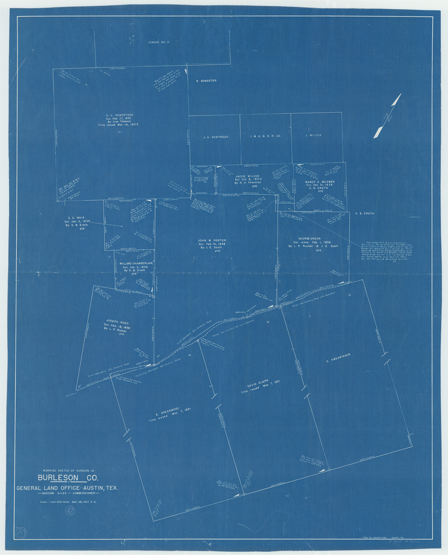
Burleson County Working Sketch 42
-
Map/Doc
67761
-
Collection
General Map Collection
-
Object Dates
9/28/1953 (Creation Date)
-
Counties
Burleson
-
Subjects
Surveying Working Sketch
-
Height x Width
41.6 x 33.6 inches
105.7 x 85.3 cm
-
Scale
1" = 500 varas
Part of: General Map Collection
Gulf Intracoastal Waterway - Tributary Channel to Aransas Pass, Location of Spoil Disposal Areas

Print $20.00
- Digital $50.00
Gulf Intracoastal Waterway - Tributary Channel to Aransas Pass, Location of Spoil Disposal Areas
1961
Size 31.5 x 41.9 inches
Map/Doc 61828
Reeves County Sketch File 17

Print $40.00
- Digital $50.00
Reeves County Sketch File 17
1943
Size 9.9 x 19.4 inches
Map/Doc 35208
Texas Land Commissioner Jerry Patterson's Great Military Map of Texas showing Significant Conflicts and Events between 1685 and 1916

Print $20.00
- Digital $50.00
Texas Land Commissioner Jerry Patterson's Great Military Map of Texas showing Significant Conflicts and Events between 1685 and 1916
2006
Size 36.7 x 24.8 inches
Map/Doc 83432
Brewster County Rolled Sketch 17

Print $40.00
- Digital $50.00
Brewster County Rolled Sketch 17
Size 25.1 x 63.4 inches
Map/Doc 5195
Rand, McNally and Co.'s Texas and Indian Territory

Print $20.00
- Digital $50.00
Rand, McNally and Co.'s Texas and Indian Territory
1883
Size 24.3 x 18.6 inches
Map/Doc 4331
Flight Mission No. BRE-1P, Frame 99, Nueces County

Print $20.00
- Digital $50.00
Flight Mission No. BRE-1P, Frame 99, Nueces County
1956
Size 18.4 x 22.2 inches
Map/Doc 86670
Map of Drum, Oyster & Bastrop Bays & vicinity in Brazoria County showing subdivision for mineral development

Print $20.00
- Digital $50.00
Map of Drum, Oyster & Bastrop Bays & vicinity in Brazoria County showing subdivision for mineral development
Size 36.8 x 47.3 inches
Map/Doc 65808
Location Survey of the Southern Kansas Railway, Kiowa Extension from a point in Drake's Location, in Indian Territory 100 miles from south line of Kansas, continuing up Wolf Creek and South Canadian River to Cottonwood Creek in Hutchinson County

Print $20.00
- Digital $50.00
Location Survey of the Southern Kansas Railway, Kiowa Extension from a point in Drake's Location, in Indian Territory 100 miles from south line of Kansas, continuing up Wolf Creek and South Canadian River to Cottonwood Creek in Hutchinson County
1886
Size 38.9 x 36.0 inches
Map/Doc 88838
Hunt County Rolled Sketch 1

Print $20.00
- Digital $50.00
Hunt County Rolled Sketch 1
Size 28.3 x 18.4 inches
Map/Doc 6266
Coast Chart No. 208 - Pass Cavallo, Lavaca and San Antonio Bays, Texas

Print $20.00
- Digital $50.00
Coast Chart No. 208 - Pass Cavallo, Lavaca and San Antonio Bays, Texas
1888
Size 43.9 x 35.7 inches
Map/Doc 73376
Lynn County Boundary File 8

Print $4.00
- Digital $50.00
Lynn County Boundary File 8
Size 10.4 x 8.6 inches
Map/Doc 56655
Nautical Chart 885-SC Intracoastal Waterway - Ellender to Galveston Bay, Louisiana-Texas

Print $40.00
- Digital $50.00
Nautical Chart 885-SC Intracoastal Waterway - Ellender to Galveston Bay, Louisiana-Texas
1972
Size 16.4 x 60.1 inches
Map/Doc 69835
You may also like
Township No. 2 South Range No. 24 West of the Indian Meridian

Print $20.00
- Digital $50.00
Township No. 2 South Range No. 24 West of the Indian Meridian
1875
Size 19.3 x 24.4 inches
Map/Doc 75174

Olney's School Atlas

Print $326.00
- Digital $50.00
Olney's School Atlas
1844
Size 12.3 x 10.0 inches
Map/Doc 93534
Red River County Working Sketch 23

Print $20.00
- Digital $50.00
Red River County Working Sketch 23
1958
Size 30.7 x 26.1 inches
Map/Doc 72006
Bee County Sketch File 9

Print $4.00
- Digital $50.00
Bee County Sketch File 9
Size 8.1 x 10.2 inches
Map/Doc 14289
Sterling County Rolled Sketch 8

Print $20.00
- Digital $50.00
Sterling County Rolled Sketch 8
1884
Size 27.9 x 31.9 inches
Map/Doc 7844
Tom Green County Boundary File 3

Print $30.00
- Digital $50.00
Tom Green County Boundary File 3
Size 14.4 x 8.7 inches
Map/Doc 59341
Reagan County Working Sketch 2

Print $20.00
- Digital $50.00
Reagan County Working Sketch 2
1919
Size 28.5 x 19.6 inches
Map/Doc 71842
Travis County Rolled Sketch 7

Print $20.00
- Digital $50.00
Travis County Rolled Sketch 7
Size 17.4 x 37.0 inches
Map/Doc 8012
Angelina County Rolled Sketch 3

Print $20.00
- Digital $50.00
Angelina County Rolled Sketch 3
Size 25.9 x 42.5 inches
Map/Doc 77186
Plat of Resurvey of Sections 5, 7 and 8, T. 5S., R. 14W. Indian Meridian, Oklahoma

Print $4.00
- Digital $50.00
Plat of Resurvey of Sections 5, 7 and 8, T. 5S., R. 14W. Indian Meridian, Oklahoma
1917
Size 18.5 x 22.6 inches
Map/Doc 75140
Lynn County Rolled Sketch WR

Print $20.00
- Digital $50.00
Lynn County Rolled Sketch WR
Size 14.7 x 23.8 inches
Map/Doc 6656