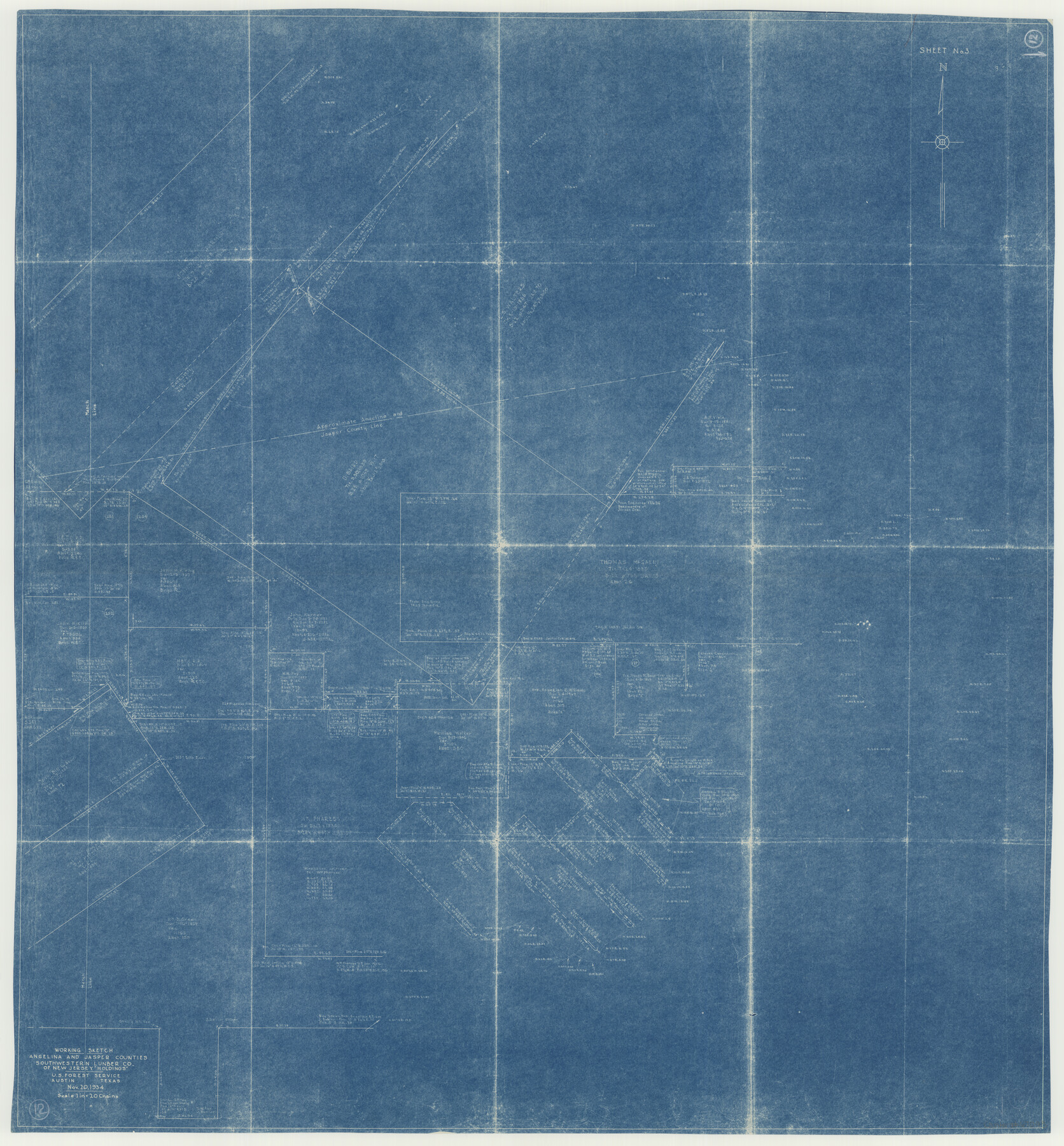
Angelina County Working Sketch 12
-
Map/Doc
67093
-
Collection
General Map Collection
-
Object Dates
11/20/1934 (Creation Date)
-
Counties
Angelina
-
Subjects
Surveying Working Sketch
-
Height x Width
40.8 x 37.9 inches
103.6 x 96.3 cm
-
Scale
1" = 20 chains
-
Comments
Surveys located about 34 miles South 60 degrees East from Lufkin, Texas.
Part of: General Map Collection
Dickens County Sketch File 18

Print $6.00
- Digital $50.00
Dickens County Sketch File 18
1959
Size 11.3 x 8.8 inches
Map/Doc 20979
Map of the Mississippi River from its Source to the Mouth of the Missouri

Print $20.00
- Digital $50.00
Map of the Mississippi River from its Source to the Mouth of the Missouri
1810
Size 10.4 x 31.3 inches
Map/Doc 95153
Zavalla County

Print $20.00
- Digital $50.00
Zavalla County
1879
Size 22.8 x 27.2 inches
Map/Doc 4182
[F. W. & D. C. Ry. Co. Alignment and Right of Way Map, Clay County]
![64726, [F. W. & D. C. Ry. Co. Alignment and Right of Way Map, Clay County], General Map Collection](https://historictexasmaps.com/wmedia_w700/maps/64726-1.tif.jpg)
Print $20.00
- Digital $50.00
[F. W. & D. C. Ry. Co. Alignment and Right of Way Map, Clay County]
1927
Size 18.6 x 11.8 inches
Map/Doc 64726
Flight Mission No. DCL-6C, Frame 115, Kenedy County

Print $20.00
- Digital $50.00
Flight Mission No. DCL-6C, Frame 115, Kenedy County
1943
Size 18.5 x 22.4 inches
Map/Doc 85945
Bandera County Sketch File 24

Print $4.00
- Digital $50.00
Bandera County Sketch File 24
Size 9.3 x 8.3 inches
Map/Doc 14014
Schleicher County Sketch File 47

Print $4.00
- Digital $50.00
Schleicher County Sketch File 47
1953
Size 4.4 x 8.7 inches
Map/Doc 36556
Runnels County Working Sketch 7

Print $20.00
- Digital $50.00
Runnels County Working Sketch 7
1929
Size 29.5 x 14.9 inches
Map/Doc 63603
Reagan County Boundary File 2

Print $20.00
- Digital $50.00
Reagan County Boundary File 2
Size 17.5 x 32.4 inches
Map/Doc 58190
Westliches - Nordamerica

Print $20.00
- Digital $50.00
Westliches - Nordamerica
1867
Size 25.3 x 20.7 inches
Map/Doc 93753
Flight Mission No. DQO-3K, Frame 30, Galveston County

Print $20.00
- Digital $50.00
Flight Mission No. DQO-3K, Frame 30, Galveston County
1952
Size 18.9 x 22.4 inches
Map/Doc 85071
Mexico or New Spain in which the Motions of Cortes may be traced

Print $20.00
- Digital $50.00
Mexico or New Spain in which the Motions of Cortes may be traced
1795
Size 14.5 x 16.5 inches
Map/Doc 93650
You may also like
Terrell County Working Sketch 32

Print $20.00
- Digital $50.00
Terrell County Working Sketch 32
1945
Size 33.0 x 36.9 inches
Map/Doc 62124
Flight Mission No. DQN-5K, Frame 149, Calhoun County

Print $20.00
- Digital $50.00
Flight Mission No. DQN-5K, Frame 149, Calhoun County
1953
Size 18.5 x 22.2 inches
Map/Doc 84424
Crockett County Rolled Sketch 57

Print $40.00
- Digital $50.00
Crockett County Rolled Sketch 57
1944
Size 52.7 x 28.0 inches
Map/Doc 8719
Brown County Working Sketch 11

Print $20.00
- Digital $50.00
Brown County Working Sketch 11
1983
Size 45.5 x 43.1 inches
Map/Doc 67776
Marion County Working Sketch 23

Print $20.00
- Digital $50.00
Marion County Working Sketch 23
1960
Size 24.4 x 25.9 inches
Map/Doc 70799
Winkler County Sketch File 14

Print $20.00
- Digital $50.00
Winkler County Sketch File 14
Size 29.4 x 24.3 inches
Map/Doc 12698
Concho County Sketch File 44

Print $6.00
- Digital $50.00
Concho County Sketch File 44
1952
Size 14.3 x 8.8 inches
Map/Doc 19207
Henderson County Sketch File 7

Print $4.00
- Digital $50.00
Henderson County Sketch File 7
1854
Size 8.6 x 8.6 inches
Map/Doc 26329
A Map of Louisiana and Mexico

Print $20.00
A Map of Louisiana and Mexico
1820
Size 43.0 x 32.6 inches
Map/Doc 76218
Colton's "New Medium" Map of the State of Texas, the Indian Territory, etc. from the latest & most authentic sources

Print $20.00
- Digital $50.00
Colton's "New Medium" Map of the State of Texas, the Indian Territory, etc. from the latest & most authentic sources
1884
Size 25.4 x 29.5 inches
Map/Doc 96524
Hemphill County Boundary File 3

Print $36.00
- Digital $50.00
Hemphill County Boundary File 3
Size 7.7 x 32.9 inches
Map/Doc 54630
Township 4 South Ranges 12 and 13 West, South Western District, Louisiana

Print $2.00
- Digital $50.00
Township 4 South Ranges 12 and 13 West, South Western District, Louisiana
1968
Size 10.5 x 7.6 inches
Map/Doc 65889