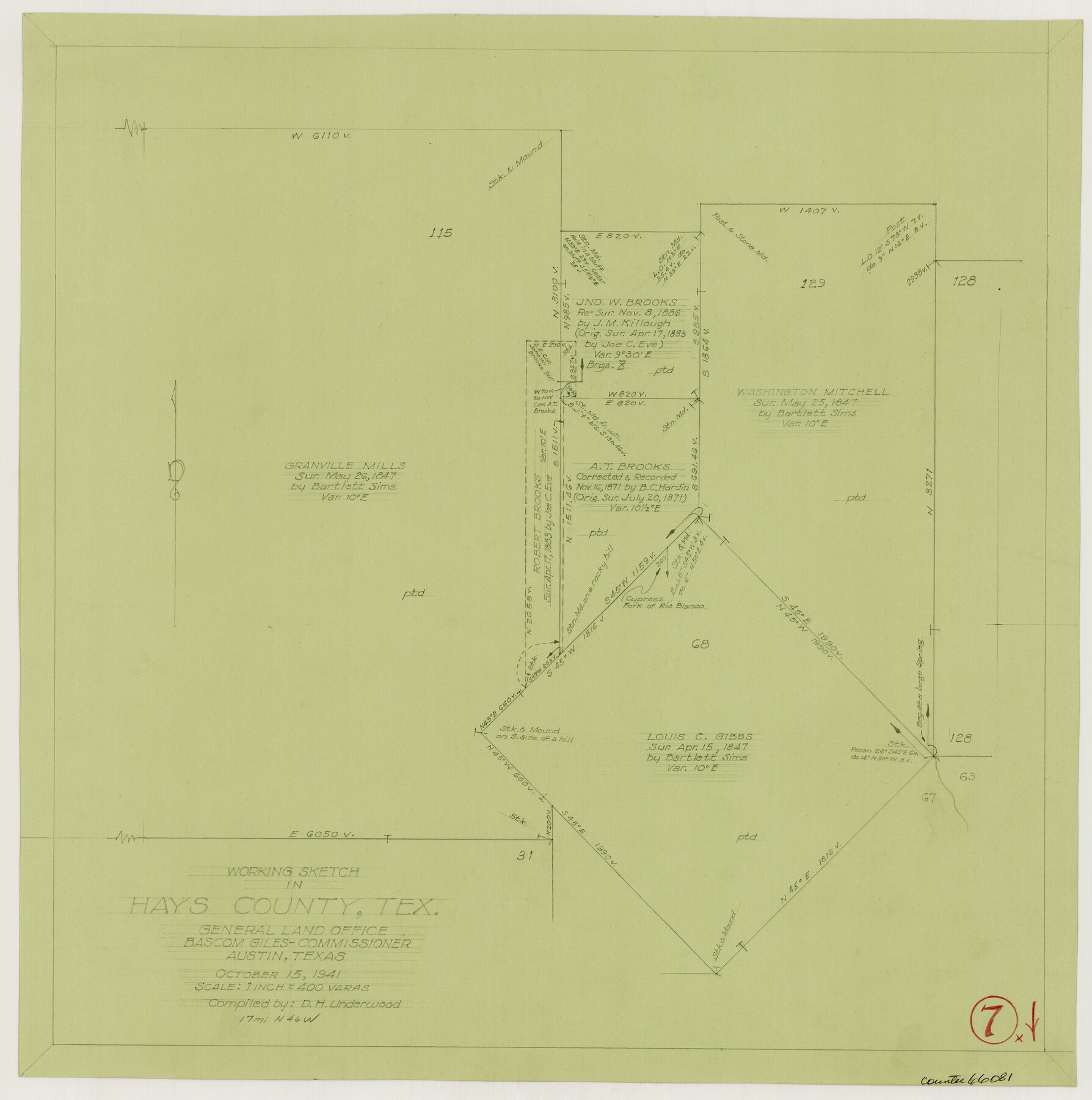
Hays County Working Sketch 7
-
Map/Doc
66081
-
Collection
General Map Collection
-
Object Dates
10/15/1941 (Creation Date)
-
People and Organizations
D.H. Underwood (Draftsman)
-
Counties
Hays
-
Subjects
Surveying Working Sketch
-
Height x Width
16.3 x 16.2 inches
41.4 x 41.2 cm
-
Scale
1" = 400 varas
Part of: General Map Collection
Flight Mission No. BQR-9K, Frame 13, Brazoria County

Print $20.00
- Digital $50.00
Flight Mission No. BQR-9K, Frame 13, Brazoria County
1952
Size 19.0 x 22.6 inches
Map/Doc 84042
Floyd County Boundary File 2b

Print $40.00
- Digital $50.00
Floyd County Boundary File 2b
Size 38.9 x 20.1 inches
Map/Doc 53490
United States - Gulf Coast - From Latitude 26° 33' to the Rio Grande Texas

Print $20.00
- Digital $50.00
United States - Gulf Coast - From Latitude 26° 33' to the Rio Grande Texas
1913
Size 18.3 x 23.6 inches
Map/Doc 72844
Stonewall County

Print $20.00
- Digital $50.00
Stonewall County
1897
Size 36.8 x 34.0 inches
Map/Doc 4057
Trinity River, Talty Sheet/Big Brushy Creek

Print $20.00
- Digital $50.00
Trinity River, Talty Sheet/Big Brushy Creek
1927
Size 42.2 x 20.3 inches
Map/Doc 65222
DeWitt County Rolled Sketch 1

Print $20.00
- Digital $50.00
DeWitt County Rolled Sketch 1
1940
Size 40.5 x 39.5 inches
Map/Doc 8777
[Bastrop District]
![83518, [Bastrop District], General Map Collection](https://historictexasmaps.com/wmedia_w700/maps/83518-1.tif.jpg)
Print $20.00
- Digital $50.00
[Bastrop District]
1838
Size 19.5 x 44.2 inches
Map/Doc 83518
Montgomery County Working Sketch 48

Print $20.00
- Digital $50.00
Montgomery County Working Sketch 48
1958
Size 24.4 x 32.1 inches
Map/Doc 71155
[Galveston, Harrisburg & San Antonio through El Paso County]
![64002, [Galveston, Harrisburg & San Antonio through El Paso County], General Map Collection](https://historictexasmaps.com/wmedia_w700/maps/64002.tif.jpg)
Print $20.00
- Digital $50.00
[Galveston, Harrisburg & San Antonio through El Paso County]
1907
Size 13.6 x 33.9 inches
Map/Doc 64002
Terry County Rolled Sketch 9

Print $20.00
- Digital $50.00
Terry County Rolled Sketch 9
Size 23.8 x 23.9 inches
Map/Doc 7983
Throckmorton County Rolled Sketch 4

Print $20.00
- Digital $50.00
Throckmorton County Rolled Sketch 4
1993
Size 23.0 x 35.0 inches
Map/Doc 7990

You may also like
Jefferson County Sketch File 5b

Print $6.00
- Digital $50.00
Jefferson County Sketch File 5b
1860
Size 9.3 x 11.1 inches
Map/Doc 28108
Cherokee County Working Sketch 27

Print $40.00
- Digital $50.00
Cherokee County Working Sketch 27
1982
Size 42.9 x 59.1 inches
Map/Doc 67982
Texas and Northern Mexico

Print $20.00
- Digital $50.00
Texas and Northern Mexico
1925
Size 21.0 x 28.3 inches
Map/Doc 95900
Fannin County Sketch File 20a

Print $7.00
- Digital $50.00
Fannin County Sketch File 20a
1889
Size 10.4 x 8.4 inches
Map/Doc 22482
El Paso County Boundary File 10

Print $14.00
- Digital $50.00
El Paso County Boundary File 10
Size 12.7 x 8.2 inches
Map/Doc 53118
Dickens County Sketch File M

Print $59.00
- Digital $50.00
Dickens County Sketch File M
1908
Size 14.6 x 9.1 inches
Map/Doc 20911
[Texas & Pacific Railway through Callahan County]
![64232, [Texas & Pacific Railway through Callahan County], General Map Collection](https://historictexasmaps.com/wmedia_w700/maps/64232.tif.jpg)
Print $20.00
- Digital $50.00
[Texas & Pacific Railway through Callahan County]
1918
Size 20.8 x 9.4 inches
Map/Doc 64232

Dawson County Working Sketch 4

Print $20.00
- Digital $50.00
Dawson County Working Sketch 4
1926
Size 32.2 x 23.8 inches
Map/Doc 68549
Flight Mission No. BRA-6M, Frame 95, Jefferson County

Print $20.00
- Digital $50.00
Flight Mission No. BRA-6M, Frame 95, Jefferson County
1953
Size 18.5 x 22.2 inches
Map/Doc 85438
Flight Mission No. CRC-2R, Frame 113, Chambers County

Print $20.00
- Digital $50.00
Flight Mission No. CRC-2R, Frame 113, Chambers County
1956
Size 18.5 x 22.5 inches
Map/Doc 84740
Reagan County Rolled Sketch 4

Print $20.00
- Digital $50.00
Reagan County Rolled Sketch 4
1928
Size 25.4 x 27.4 inches
Map/Doc 7433