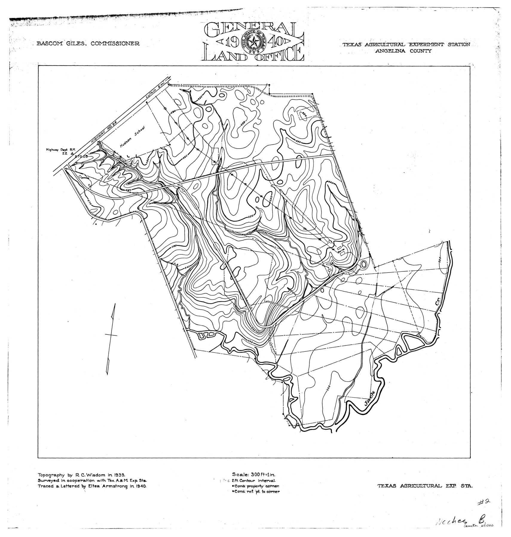
Neches River, Texas Agricultural Experiment Station
- 
                          Map/Doc
65080
 - 
                            Collection
General Map Collection
 - 
                            Object Dates
1940 (Creation Date)
 - 
                            People and Organizations
Texas General Land Office (Publisher)
Eltea Armstrong (Compiler)
Eltea Armstrong (Draftsman)
Bascom Giles (GLO Commissioner)
R.C. Wisdom (Surveyor/Engineer)
 - 
                            Counties
Angelina
 - 
                            Subjects
River Surveys Topographic
 - 
                            Height x Width
21.7 x 20.6 inches
55.1 x 52.3 cm
 
Part of: General Map Collection
            Angelina County Sketch File 5a


                                            Print $4.00                    
                                             -                         Digital $50.00                                    
                Angelina County Sketch File 5a
1857
Size 8.6 x 7.7 inches
                                Map/Doc 12931
            
            [Folder for] Nautical Chart 11303: Texas Intracoastal Waterway, Laguna Madre, Chubby Island to Stover Point including the Arroyo Colorado


                                            Print $20.00                    
                                             -                         Digital $50.00                                    
                [Folder for] Nautical Chart 11303: Texas Intracoastal Waterway, Laguna Madre, Chubby Island to Stover Point including the Arroyo Colorado
1976
Size 15.9 x 18.8 inches
                                Map/Doc 75914
            
            Wood County Rolled Sketch 1


                                            Print $40.00                    
                                             -                         Digital $50.00                                    
                Wood County Rolled Sketch 1
1941
Size 53.2 x 43.8 inches
                                Map/Doc 10159
            
            Fannin County


                                            Print $20.00                    
                                             -                         Digital $50.00                                    
                Fannin County
1946
Size 42.3 x 37.4 inches
                                Map/Doc 73145
            
            Edwards County Sketch File ECS


                                            Print $6.00                    
                                             -                         Digital $50.00                                    
                Edwards County Sketch File ECS
1937
Size 11.5 x 8.8 inches
                                Map/Doc 21774
            
            Fort Bend Co.


                                            Print $20.00                    
                                             -                         Digital $50.00                                    
                Fort Bend Co.
1931
Size 40.5 x 41.3 inches
                                Map/Doc 77282
            
            Jefferson County Sketch File 56


                                            Print $34.00                    
                                             -                         Digital $50.00                                    
                Jefferson County Sketch File 56
2007
Map/Doc 93427
            
            Current Miscellaneous File 84


                                            Print $10.00                    
                                             -                         Digital $50.00                                    
                Current Miscellaneous File 84
1954
Size 11.2 x 8.8 inches
                                Map/Doc 74231
            
            Harris County Working Sketch 22


                                            Print $20.00                    
                                             -                         Digital $50.00                                    
                Harris County Working Sketch 22
Size 17.5 x 22.0 inches
                                Map/Doc 65914
            
            Val Verde County Sketch File XXX2


                                            Print $20.00                    
                                             -                         Digital $50.00                                    
                Val Verde County Sketch File XXX2
Size 18.6 x 17.9 inches
                                Map/Doc 12548
            
            Map of the Lands Surveyed by the Memphis, El Paso & Pacific R.R. Company


                                            Print $20.00                    
                                             -                         Digital $50.00                                    
                Map of the Lands Surveyed by the Memphis, El Paso & Pacific R.R. Company
1859
Size 13.9 x 21.3 inches
                                Map/Doc 4849
            
            Foard County Working Sketch 11


                                            Print $20.00                    
                                             -                         Digital $50.00                                    
                Foard County Working Sketch 11
1977
Size 26.7 x 35.6 inches
                                Map/Doc 69202
            You may also like
            Map No. 1 - Rio Bravo del Norte section of boundary between the United States & Mexico agreed upon by the Joint Commission under the Treaty of Guadalupe Hidalgo


                                            Print $20.00                    
                                             -                         Digital $50.00                                    
                Map No. 1 - Rio Bravo del Norte section of boundary between the United States & Mexico agreed upon by the Joint Commission under the Treaty of Guadalupe Hidalgo
1852
Size 18.4 x 27.0 inches
                                Map/Doc 72864
            
            Map showing the environs of Brazos Islnd. Texas


                                            Print $20.00                    
                                             -                         Digital $50.00                                    
                Map showing the environs of Brazos Islnd. Texas
1864
Size 26.2 x 18.2 inches
                                Map/Doc 72914
            
            Boundary Between U.S. - Mexico, 1853


                                            Print $20.00                    
                                             -                         Digital $50.00                                    
                Boundary Between U.S. - Mexico, 1853
1954
Size 24.3 x 18.4 inches
                                Map/Doc 65416
            
            Jasper County Sketch File 15


                                            Print $6.00                    
                                             -                         Digital $50.00                                    
                Jasper County Sketch File 15
Size 9.9 x 15.3 inches
                                Map/Doc 27806
            
            Pecos County Rolled Sketch 14


                                            Print $40.00                    
                                             -                         Digital $50.00                                    
                Pecos County Rolled Sketch 14
Size 39.5 x 82.3 inches
                                Map/Doc 75942
            
            [Blocks 47, Z, XO2, M18, M23, M25, and H]


                                            Print $20.00                    
                                             -                         Digital $50.00                                    
                [Blocks 47, Z, XO2, M18, M23, M25, and H]
Size 29.6 x 23.6 inches
                                Map/Doc 91236
            
            Flight Mission No. CGI-3N, Frame 169, Cameron County


                                            Print $20.00                    
                                             -                         Digital $50.00                                    
                Flight Mission No. CGI-3N, Frame 169, Cameron County
1954
Size 18.6 x 22.3 inches
                                Map/Doc 84633
            
            Briscoe County Sketch File A


                                            Print $40.00                    
                                             -                         Digital $50.00                                    
                Briscoe County Sketch File A
1894
Size 17.3 x 21.1 inches
                                Map/Doc 10997
            
            King County Working Sketch 10


                                            Print $20.00                    
                                             -                         Digital $50.00                                    
                King County Working Sketch 10
1956
Size 19.1 x 13.9 inches
                                Map/Doc 70174
            
            Reeves County Working Sketch 20


                                            Print $40.00                    
                                             -                         Digital $50.00                                    
                Reeves County Working Sketch 20
1964
Size 37.6 x 50.4 inches
                                Map/Doc 63463
            
            Hardin County Sketch File 70


                                            Print $4.00                    
                                             -                         Digital $50.00                                    
                Hardin County Sketch File 70
1895
Size 11.2 x 9.0 inches
                                Map/Doc 25257
            
            Flight Mission No. CGI-4N, Frame 171, Cameron County


                                            Print $20.00                    
                                             -                         Digital $50.00                                    
                Flight Mission No. CGI-4N, Frame 171, Cameron County
1955
Size 18.5 x 22.4 inches
                                Map/Doc 84674