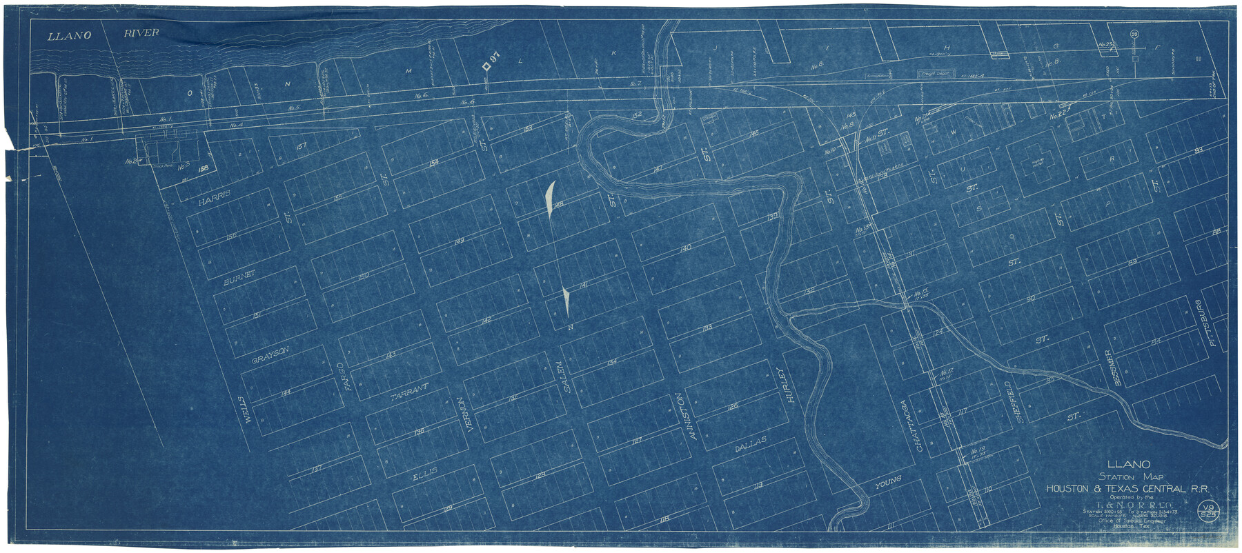
Llano Station Map, Houston & Texas Central R.R. operated by the T. & N. O. R.R. Co.
Station 5100+95 to Station 5154+73
Z-2-172
- 
                          Map/Doc
64559
 - 
                            Collection
General Map Collection
 - 
                            Object Dates
6/30/1918 (Creation Date)
12/31/1927 (Revision Date)
12/31/1930 (Revision Date)
 - 
                            Counties
Llano
 - 
                            Subjects
Railroads
 - 
                            Height x Width
25.8 x 57.1 inches
65.5 x 145.0 cm
 - 
                            Medium
blueprint/diazo
 - 
                            Scale
1" = 100 feet
 - 
                            Comments
Texas and New Orleans Railroad; Austin Branch.
See counter nos. 64553 through 64558 for other sheets of the map. - 
                            Features
H&TC
Llano River
[Llano]
 
Part of: General Map Collection
            Ward County Working Sketch 34


                                            Print $20.00                    
                                             -                         Digital $50.00                                    
                Ward County Working Sketch 34
1968
Size 26.7 x 30.5 inches
                                Map/Doc 72340
            
            Tarrant County Sketch File 14


                                            Print $7.00                    
                                             -                         Digital $50.00                                    
                Tarrant County Sketch File 14
1859
Size 10.2 x 8.4 inches
                                Map/Doc 37705
            
            Kenedy County Aerial Photograph Index Sheet 5


                                            Print $20.00                    
                                             -                         Digital $50.00                                    
                Kenedy County Aerial Photograph Index Sheet 5
1943
Size 23.5 x 19.6 inches
                                Map/Doc 89046
            
            Flight Mission No. BRA-3M, Frame 120, Jefferson County


                                            Print $20.00                    
                                             -                         Digital $50.00                                    
                Flight Mission No. BRA-3M, Frame 120, Jefferson County
1953
Size 18.6 x 22.3 inches
                                Map/Doc 85394
            
            Cherokee County Sketch File 30


                                            Print $17.00                    
                                             -                         Digital $50.00                                    
                Cherokee County Sketch File 30
1934
Size 10.3 x 9.4 inches
                                Map/Doc 18176
            
            Harris County Rolled Sketch P3


                                            Print $20.00                    
                                             -                         Digital $50.00                                    
                Harris County Rolled Sketch P3
1933
Size 13.9 x 20.0 inches
                                Map/Doc 6142
            
            El Paso County


                                            Print $40.00                    
                                             -                         Digital $50.00                                    
                El Paso County
1881
Size 53.7 x 88.3 inches
                                Map/Doc 16826
            
            Index sheet to accompany map of survey for connecting the inland waters along margin of the Gulf of Mexico from Donaldsonville in Louisiana to the Rio Grande River in Texas


                                            Print $20.00                    
                                             -                         Digital $50.00                                    
                Index sheet to accompany map of survey for connecting the inland waters along margin of the Gulf of Mexico from Donaldsonville in Louisiana to the Rio Grande River in Texas
1873
Size 18.2 x 28.2 inches
                                Map/Doc 72693
            
            Edwards County Working Sketch 124


                                            Print $20.00                    
                                             -                         Digital $50.00                                    
                Edwards County Working Sketch 124
1976
Size 20.0 x 27.8 inches
                                Map/Doc 69000
            
            Flight Mission No. DAG-24K, Frame 138, Matagorda County


                                            Print $20.00                    
                                             -                         Digital $50.00                                    
                Flight Mission No. DAG-24K, Frame 138, Matagorda County
1953
Size 18.4 x 15.8 inches
                                Map/Doc 86556
            
            Flight Mission No. CRK-5P, Frame 155, Refugio County


                                            Print $20.00                    
                                             -                         Digital $50.00                                    
                Flight Mission No. CRK-5P, Frame 155, Refugio County
1956
Size 18.7 x 22.6 inches
                                Map/Doc 86936
            
            Presidio County Rolled Sketch 53


                                            Print $20.00                    
                                             -                         Digital $50.00                                    
                Presidio County Rolled Sketch 53
1911
Size 13.0 x 22.2 inches
                                Map/Doc 7346
            You may also like
            East Part El Paso County


                                            Print $20.00                    
                                             -                         Digital $50.00                                    
                East Part El Paso County
1908
Size 47.6 x 40.9 inches
                                Map/Doc 66814
            
            Hutchinson County Sketch File 46


                                            Print $50.00                    
                                             -                         Digital $50.00                                    
                Hutchinson County Sketch File 46
1981
Size 11.2 x 8.7 inches
                                Map/Doc 27365
            
            Go Turnpike! Dallas-Fort Worth Turnpike (Verso)


            Go Turnpike! Dallas-Fort Worth Turnpike (Verso)
1963
Size 11.2 x 17.2 inches
                                Map/Doc 94178
            
            Lavaca County Working Sketch 17


                                            Print $20.00                    
                                             -                         Digital $50.00                                    
                Lavaca County Working Sketch 17
1979
Size 34.7 x 44.6 inches
                                Map/Doc 70370
            
            Brewster County Sketch File N-10


                                            Print $14.00                    
                                             -                         Digital $50.00                                    
                Brewster County Sketch File N-10
1922
Size 11.2 x 8.7 inches
                                Map/Doc 15616
            
            Runnels County Sketch File 41


                                            Print $20.00                    
                                    
                Runnels County Sketch File 41
1892
Size 22.8 x 25.7 inches
                                Map/Doc 12271
            
            Hardin County Sketch File 17


                                            Print $6.00                    
                                             -                         Digital $50.00                                    
                Hardin County Sketch File 17
1854
Size 15.9 x 9.9 inches
                                Map/Doc 25130
            
            Flight Mission No. DCL-6C, Frame 50, Kenedy County


                                            Print $20.00                    
                                             -                         Digital $50.00                                    
                Flight Mission No. DCL-6C, Frame 50, Kenedy County
1943
Size 18.7 x 22.4 inches
                                Map/Doc 85892
            
            North Part Brewster Co.


                                            Print $40.00                    
                                             -                         Digital $50.00                                    
                North Part Brewster Co.
1914
Size 48.4 x 37.8 inches
                                Map/Doc 89864
            
            Map of Part of Texas Prison System, Blue Ridge State Farm, Fort Bend and Harris Counties


                                            Print $20.00                    
                                             -                         Digital $50.00                                    
                Map of Part of Texas Prison System, Blue Ridge State Farm, Fort Bend and Harris Counties
Size 24.1 x 26.3 inches
                                Map/Doc 62981
            
            Terrell County Working Sketch 73


                                            Print $20.00                    
                                             -                         Digital $50.00                                    
                Terrell County Working Sketch 73
1980
Size 29.0 x 47.5 inches
                                Map/Doc 69594
            
            Donley County Working Sketch 9


                                            Print $20.00                    
                                             -                         Digital $50.00                                    
                Donley County Working Sketch 9
1982
Size 24.7 x 42.2 inches
                                Map/Doc 68742