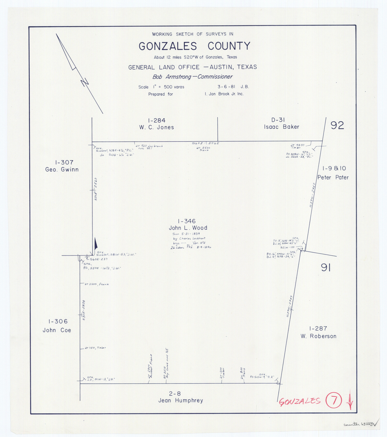
Gonzales County Working Sketch 7
-
Map/Doc
63223
-
Collection
General Map Collection
-
Object Dates
3/6/1981 (Creation Date)
-
People and Organizations
Jana Brod (Draftsman)
-
Counties
Gonzales
-
Subjects
Surveying Working Sketch
-
Height x Width
19.1 x 17.0 inches
48.5 x 43.2 cm
-
Scale
1" = 500 varas
Part of: General Map Collection
Garza County Working Sketch 6

Print $20.00
- Digital $50.00
Garza County Working Sketch 6
1944
Size 24.8 x 20.2 inches
Map/Doc 63153
Jasper County Working Sketch 10

Print $20.00
- Digital $50.00
Jasper County Working Sketch 10
1917
Size 17.4 x 22.7 inches
Map/Doc 66472
Andrews County Rolled Sketch 41

Print $20.00
- Digital $50.00
Andrews County Rolled Sketch 41
Size 18.0 x 24.0 inches
Map/Doc 77181
Kerr County Boundary File 3

Print $6.00
- Digital $50.00
Kerr County Boundary File 3
Size 11.3 x 8.8 inches
Map/Doc 55998
Galveston Island

Print $20.00
- Digital $50.00
Galveston Island
1837
Size 24.1 x 37.2 inches
Map/Doc 2009
Flight Mission No. BRA-8M, Frame 78, Jefferson County

Print $20.00
- Digital $50.00
Flight Mission No. BRA-8M, Frame 78, Jefferson County
1953
Size 15.9 x 15.8 inches
Map/Doc 85598
Henderson County Rolled Sketch 11

Print $20.00
- Digital $50.00
Henderson County Rolled Sketch 11
1915
Size 29.4 x 42.4 inches
Map/Doc 75950
Bosque County Sketch File 32

Print $42.00
- Digital $50.00
Bosque County Sketch File 32
1944
Size 19.6 x 18.6 inches
Map/Doc 10938
Montague County Sketch File 17

Print $40.00
- Digital $50.00
Montague County Sketch File 17
1893
Size 14.3 x 16.6 inches
Map/Doc 31744
Map of Houston County

Print $40.00
- Digital $50.00
Map of Houston County
1841
Size 58.6 x 32.2 inches
Map/Doc 1952
Intracoastal Waterway in Texas - Corpus Christi to Point Isabel including Arroyo Colorado to Mo. Pac. R.R. Bridge Near Harlingen

Print $20.00
- Digital $50.00
Intracoastal Waterway in Texas - Corpus Christi to Point Isabel including Arroyo Colorado to Mo. Pac. R.R. Bridge Near Harlingen
1933
Size 28.1 x 40.8 inches
Map/Doc 61876
Starr County Working Sketch 28

Print $20.00
- Digital $50.00
Starr County Working Sketch 28
2004
Size 28.0 x 39.6 inches
Map/Doc 83010
You may also like
Williamson County Sketch File 23

Print $4.00
- Digital $50.00
Williamson County Sketch File 23
1877
Size 12.8 x 8.1 inches
Map/Doc 40353
Presidio County Rolled Sketch 56

Print $20.00
- Digital $50.00
Presidio County Rolled Sketch 56
1915
Size 21.8 x 17.1 inches
Map/Doc 7349
Hutchinson County Sketch File 53

Print $2.00
- Digital $50.00
Hutchinson County Sketch File 53
2000
Size 11.2 x 8.8 inches
Map/Doc 27455
[Geo. W. Woodley, W. B. Ralls, Boyd Bros. and surrounding surveys]
![90455, [Geo. W. Woodley, W. B. Ralls, Boyd Bros. and surrounding surveys], Twichell Survey Records](https://historictexasmaps.com/wmedia_w700/maps/90455-1.tif.jpg)
Print $3.00
- Digital $50.00
[Geo. W. Woodley, W. B. Ralls, Boyd Bros. and surrounding surveys]
Size 11.7 x 12.6 inches
Map/Doc 90455
Travis County Working Sketch 65

Print $20.00
- Digital $50.00
Travis County Working Sketch 65
2003
Size 28.1 x 38.3 inches
Map/Doc 78494
Van Zandt County

Print $20.00
- Digital $50.00
Van Zandt County
1857
Size 20.0 x 25.3 inches
Map/Doc 8144
[Map of the Stockdale-Cuero Extension G.H. & S.A. Ry.]
![64095, [Map of the Stockdale-Cuero Extension G.H. & S.A. Ry.], General Map Collection](https://historictexasmaps.com/wmedia_w700/maps/64095.tif.jpg)
Print $40.00
- Digital $50.00
[Map of the Stockdale-Cuero Extension G.H. & S.A. Ry.]
1905
Size 19.6 x 128.0 inches
Map/Doc 64095
Kimble County Working Sketch 75

Print $20.00
- Digital $50.00
Kimble County Working Sketch 75
1968
Size 32.0 x 35.7 inches
Map/Doc 70143
Donley County Working Sketch 9

Print $20.00
- Digital $50.00
Donley County Working Sketch 9
1982
Size 24.7 x 42.2 inches
Map/Doc 68742
Kent County Boundary File 8

Print $20.00
- Digital $50.00
Kent County Boundary File 8
Size 14.2 x 8.6 inches
Map/Doc 55873
General Highway Map, Guadalupe County, Texas

Print $20.00
General Highway Map, Guadalupe County, Texas
1940
Size 18.6 x 25.1 inches
Map/Doc 79107
Reeves County

Print $20.00
- Digital $50.00
Reeves County
1903
Size 47.3 x 35.6 inches
Map/Doc 66997