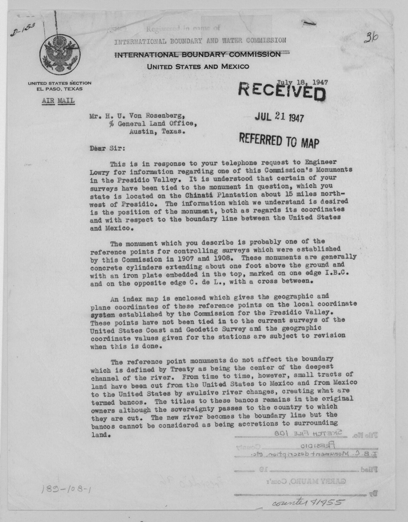
Presidio County Sketch File 108
[Correspondence regarding International Boundary Commission monuments northwest of Presidio]
-
Map/Doc
41455
-
Collection
General Map Collection
-
Object Dates
9/9/1952 (File Date)
7/18/1947 (Correspondence Date)
-
Counties
Presidio
-
Subjects
Surveying Sketch File
-
Height x Width
10.9 x 8.5 inches
27.7 x 21.6 cm
-
Medium
paper, print
-
Comments
See Presidio County Rolled Sketch 96 (9782) for sketch.
-
Features
Presidio Valley
Chinati Plantation
Rio Grande River
Related maps
Presidio County Rolled Sketch 96

Print $20.00
- Digital $50.00
Presidio County Rolled Sketch 96
Size 12.3 x 45.9 inches
Map/Doc 9782
Part of: General Map Collection
Flight Mission No. BRA-6M, Frame 91, Jefferson County

Print $20.00
- Digital $50.00
Flight Mission No. BRA-6M, Frame 91, Jefferson County
1953
Size 18.5 x 22.4 inches
Map/Doc 85434
Zapata County Sketch File 5

Print $20.00
- Digital $50.00
Zapata County Sketch File 5
1886
Size 15.4 x 16.9 inches
Map/Doc 12719
Runnels County Sketch File 29

Print $20.00
Runnels County Sketch File 29
1950
Size 23.8 x 18.0 inches
Map/Doc 12261
Atascosa County Sketch File 1

Print $8.00
- Digital $50.00
Atascosa County Sketch File 1
Size 8.1 x 6.1 inches
Map/Doc 13718
Concho County Sketch File X

Print $20.00
- Digital $50.00
Concho County Sketch File X
1916
Size 39.4 x 23.7 inches
Map/Doc 11168
Clay County Sketch File 48

Print $26.00
- Digital $50.00
Clay County Sketch File 48
1919
Size 14.2 x 8.6 inches
Map/Doc 18487
Dickens County Rolled Sketch 8

Print $20.00
- Digital $50.00
Dickens County Rolled Sketch 8
1953
Size 42.9 x 23.7 inches
Map/Doc 5707
Map of Calhoun County

Print $20.00
- Digital $50.00
Map of Calhoun County
1863
Size 23.0 x 19.5 inches
Map/Doc 887
Kimble County Working Sketch 8

Print $20.00
- Digital $50.00
Kimble County Working Sketch 8
1918
Size 27.4 x 12.9 inches
Map/Doc 70076
Harrison County Working Sketch 5

Print $20.00
- Digital $50.00
Harrison County Working Sketch 5
1953
Size 39.7 x 39.8 inches
Map/Doc 66025
Map of the City of Washington showing location of fatal cases of Diphtheria and Scarlet Fever; also number of cases thereof reported to the Health Department during the year ending June 30, 1896

Print $20.00
- Digital $50.00
Map of the City of Washington showing location of fatal cases of Diphtheria and Scarlet Fever; also number of cases thereof reported to the Health Department during the year ending June 30, 1896
1896
Size 30.0 x 29.4 inches
Map/Doc 97103
Limestone County

Print $40.00
- Digital $50.00
Limestone County
1922
Size 50.6 x 36.2 inches
Map/Doc 73342
You may also like
[Plat Showing Jeremiah Kirby, Champion Choat, A. M. Lejarza & Hardin Co. School Lands]
![5040, [Plat Showing Jeremiah Kirby, Champion Choat, A. M. Lejarza & Hardin Co. School Lands], Maddox Collection](https://historictexasmaps.com/wmedia_w700/maps/5040.tif.jpg)
Print $20.00
- Digital $50.00
[Plat Showing Jeremiah Kirby, Champion Choat, A. M. Lejarza & Hardin Co. School Lands]
Size 28.8 x 38.9 inches
Map/Doc 5040
Laneer vs. Bivins, Potter County, Texas

Print $20.00
- Digital $50.00
Laneer vs. Bivins, Potter County, Texas
Size 20.0 x 18.7 inches
Map/Doc 93104
General Highway Map, Grimes County, Texas

Print $20.00
General Highway Map, Grimes County, Texas
1961
Size 24.8 x 18.1 inches
Map/Doc 79490
Throckmorton County Sketch File 6a

Print $20.00
- Digital $50.00
Throckmorton County Sketch File 6a
1897
Size 14.5 x 12.7 inches
Map/Doc 38089
Flight Mission No. BRA-7M, Frame 37, Jefferson County

Print $20.00
- Digital $50.00
Flight Mission No. BRA-7M, Frame 37, Jefferson County
1953
Size 18.7 x 22.4 inches
Map/Doc 85488
McCulloch County Working Sketch 13

Print $20.00
- Digital $50.00
McCulloch County Working Sketch 13
1989
Size 36.7 x 33.3 inches
Map/Doc 70688
Anderson County Working Sketch 3

Print $20.00
- Digital $50.00
Anderson County Working Sketch 3
Size 15.4 x 14.1 inches
Map/Doc 67002
Red River County Sketch File 7

Print $6.00
- Digital $50.00
Red River County Sketch File 7
1855
Size 12.7 x 8.0 inches
Map/Doc 35109
Harris County Working Sketch 95

Print $20.00
- Digital $50.00
Harris County Working Sketch 95
1978
Size 26.6 x 44.1 inches
Map/Doc 65987
The Republic County of Washington. February 1, 1844

Print $20.00
The Republic County of Washington. February 1, 1844
2020
Size 11.8 x 21.7 inches
Map/Doc 96309
Flight Mission No. BRA-6M, Frame 152, Jefferson County

Print $20.00
- Digital $50.00
Flight Mission No. BRA-6M, Frame 152, Jefferson County
1953
Size 18.6 x 22.3 inches
Map/Doc 85453
[Surveys near Keechi Creek and the Trinity River]
![47, [Surveys near Keechi Creek and the Trinity River], General Map Collection](https://historictexasmaps.com/wmedia_w700/maps/47.tif.jpg)
Print $2.00
- Digital $50.00
[Surveys near Keechi Creek and the Trinity River]
1841
Size 8.6 x 8.2 inches
Map/Doc 47