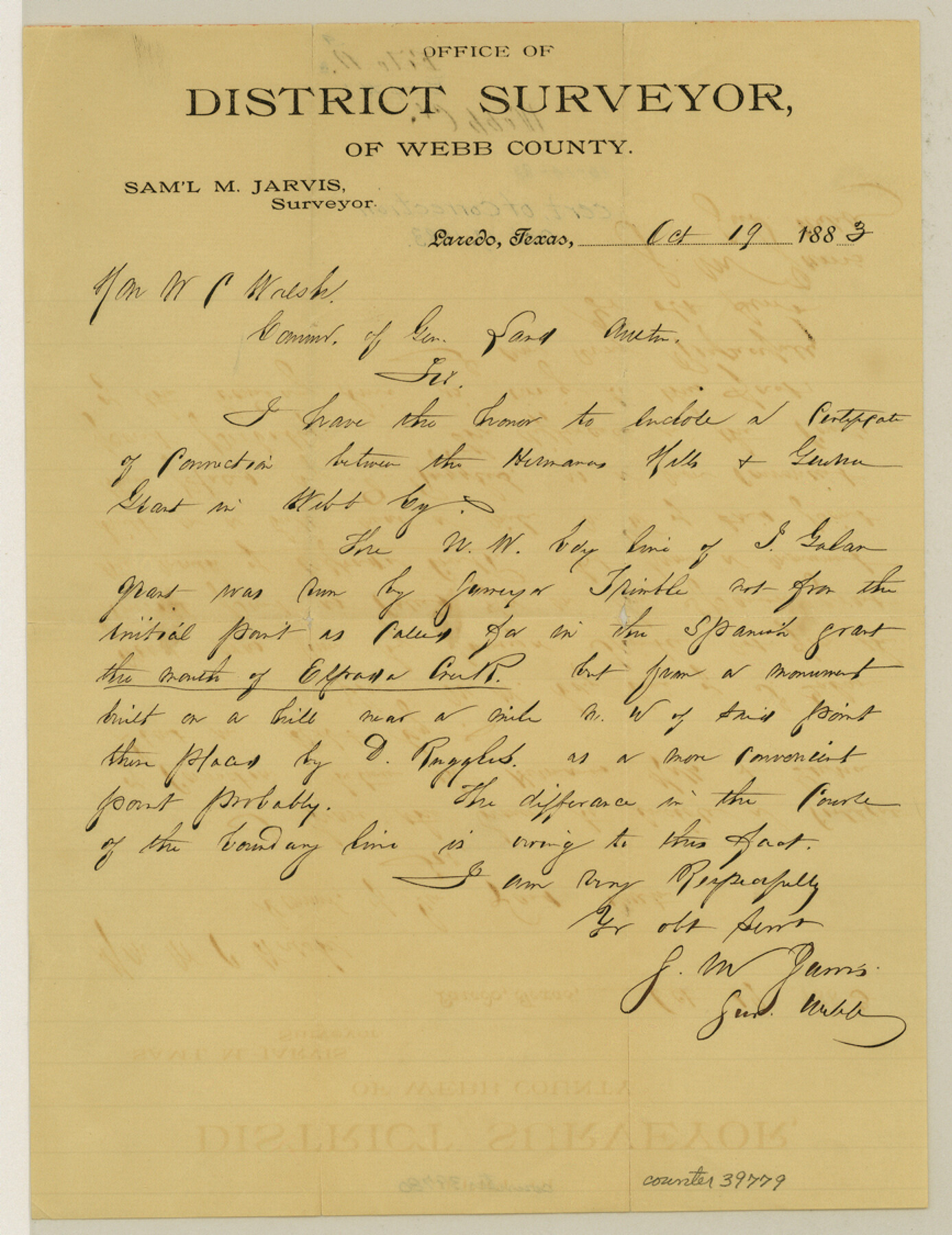
Webb County Sketch File 11a
[Certificate of correction regarding northwest boundary line of Joaquin Galan grant]
-
Map/Doc
39779
-
Collection
General Map Collection
-
Object Dates
10/19/1883 (Creation Date)
-
People and Organizations
Samuel M. Jarvis (Surveyor/Engineer)
-
Counties
Webb
-
Subjects
Surveying Sketch File
-
Height x Width
11.2 x 8.7 inches
28.5 x 22.1 cm
-
Medium
paper, manuscript
-
Features
Hermanos Hills
Espada Creek
Part of: General Map Collection
Flight Mission No. CGI-4N, Frame 171, Cameron County

Print $20.00
- Digital $50.00
Flight Mission No. CGI-4N, Frame 171, Cameron County
1955
Size 18.5 x 22.4 inches
Map/Doc 84674
Willacy County Aerial Photograph Index Sheet 1

Print $20.00
- Digital $50.00
Willacy County Aerial Photograph Index Sheet 1
1940
Size 24.0 x 19.7 inches
Map/Doc 83755
San Antonio & Aransas Pass

Print $40.00
- Digital $50.00
San Antonio & Aransas Pass
Size 30.9 x 74.5 inches
Map/Doc 64633
Freestone County Working Sketch 18

Print $20.00
- Digital $50.00
Freestone County Working Sketch 18
1980
Size 43.3 x 46.9 inches
Map/Doc 69260
A New Map of Texas

Print $20.00
- Digital $50.00
A New Map of Texas
1841
Size 18.2 x 17.2 inches
Map/Doc 96636

Hardin County Sketch File 65

Print $15.00
- Digital $50.00
Hardin County Sketch File 65
Size 14.4 x 9.0 inches
Map/Doc 25245
Crosby County Working Sketch 16

Print $40.00
- Digital $50.00
Crosby County Working Sketch 16
1979
Size 37.4 x 59.3 inches
Map/Doc 68450
Township 14 South Range 14 West, South Western District, Louisiana

Print $20.00
- Digital $50.00
Township 14 South Range 14 West, South Western District, Louisiana
1838
Size 19.5 x 24.8 inches
Map/Doc 65858
Frio County Rolled Sketch 25

Print $20.00
- Digital $50.00
Frio County Rolled Sketch 25
1965
Size 25.0 x 30.6 inches
Map/Doc 5925
Parker County Sketch File 49

Print $6.00
- Digital $50.00
Parker County Sketch File 49
Size 10.6 x 8.8 inches
Map/Doc 33618
Trinity River, Eagle Ford Sheet/Trinity and Elm Fork of Trinity River

Print $20.00
- Digital $50.00
Trinity River, Eagle Ford Sheet/Trinity and Elm Fork of Trinity River
1917
Size 29.5 x 23.2 inches
Map/Doc 69685
You may also like
Sketch of Part of Crockett County, Texas

Print $20.00
- Digital $50.00
Sketch of Part of Crockett County, Texas
1925
Size 20.0 x 18.0 inches
Map/Doc 92545
Bosque County, Texas School Map

Print $20.00
- Digital $50.00
Bosque County, Texas School Map
1932
Size 40.9 x 36.6 inches
Map/Doc 81918
Andrews County Rolled Sketch 14A

Print $20.00
- Digital $50.00
Andrews County Rolled Sketch 14A
1934
Size 31.2 x 23.6 inches
Map/Doc 77165
A Visit to Texas: Being The Journal of a Traveler Through Those Parts Most Interesting to American Settlers. With Descriptions of Scenery, Habits, & c. &c.

Print $560.00
- Digital $50.00
A Visit to Texas: Being The Journal of a Traveler Through Those Parts Most Interesting to American Settlers. With Descriptions of Scenery, Habits, & c. &c.
1834
Size 8.0 x 5.2 inches
Map/Doc 93849
Scurry County Rolled Sketch 9

Print $20.00
- Digital $50.00
Scurry County Rolled Sketch 9
1963
Size 23.0 x 22.0 inches
Map/Doc 7769
Culberson County Sketch File 3a

Print $3.00
- Digital $50.00
Culberson County Sketch File 3a
1879
Size 8.0 x 16.7 inches
Map/Doc 20122
Real County Working Sketch 74

Print $20.00
- Digital $50.00
Real County Working Sketch 74
1979
Size 17.1 x 23.5 inches
Map/Doc 71966
Coke County Working Sketch 23

Print $20.00
- Digital $50.00
Coke County Working Sketch 23
1954
Size 42.4 x 35.7 inches
Map/Doc 68060
C. C. Born Farm South Half Section 91, Block C

Print $20.00
- Digital $50.00
C. C. Born Farm South Half Section 91, Block C
Size 20.5 x 12.9 inches
Map/Doc 92314
Map of Galveston Bay from Lawrence Cove to Stevenson's Station

Print $20.00
- Digital $50.00
Map of Galveston Bay from Lawrence Cove to Stevenson's Station
1851
Size 41.5 x 30.0 inches
Map/Doc 69922
Crockett County Rolled Sketch 88L

Print $20.00
- Digital $50.00
Crockett County Rolled Sketch 88L
1963
Size 19.0 x 24.6 inches
Map/Doc 5628
Austin's Register of Families Vol. 1

Austin's Register of Families Vol. 1
Size 14.0 x 10.2 inches
Map/Doc 94249